Camelid Country Home Page. |
Facts at a Glance |
|
|
Capital:
|
Edmonton
|
Alberta

The province of Alberta has a total area of 255, 287 square miles (661,190 square kilometers). 6,485 square miles (16,800 square kilometers.) of this is covered by freshwater lakes.
Alberta is a landlocked province with 0 miles (0 kilometers) of coastline.
arable land:
permanent crops:
permanent pastures:
forests and woodlands:
other:
In 1996, there were 1,276,547 acres (510,619 hectares) of irrigated land in the province. This is almost unchanged from 1991, when there were 1,132,086 acres (452,834 hectares) under irrigation.
Alberta has, by far, more land under irrigation that any of the other three western Canadian provinces.
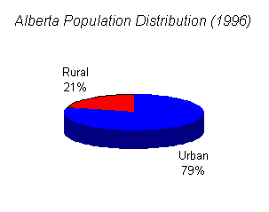
According to the 1996 Census, approximately 21% of Alberta's 2,696,826 people lived in rural areas of the province. The remaining 79% live in urban areas.
For the purposes of the census, Statistics Canada defines urban areas as those that "have a minimum population concentration of 1,000 and a population density of at least 400 per square kilometre, based on the previous census population counts." All remaining areas in the province are rural areas.
Agriculture:
Industry:
Services:
total:
by occupation:
For statistical purposes, Statistics Canada defines a census farm as an agricultural operation "producing at least one of the following products for sale: Crops (field crops, tree fruits or nuts, berries or grapes, vegetables, seed), Livestock (cattle, pigs, sheep, horses, game animals, other livestock), Poultry (hens, chickens, turkeys, chicks, game birds, other poultry), Animal Products (milk or cream, eggs, wool, furs, meat), or Other Agricultural Products (greenhouse or nursery products, Christmas trees, mushrooms, sod, honey, maple syrup products)."
In 1996, there were 59,007 census farms in the province of Alberta, of which 16,900 generated gross farm receipts of $100,000CAN or more.
The aveage census farm size was 881 acres (352 hectares)--slightly smaller than in 1991.
The average capital value of an Alberta census farm in 1996 was $680,435CAN. Statistics Canada includes the value of the following assets in determining the capital value of a farm: all land, buildings, machinery, equipment (including passenger vehicles), livestock and poultry. "Farm capital does not include the value of crops in the field or in storage, or farm inputs on hand, such as fertilizer and seed."
Camelid Country Home Page. |
|
Previous Section: British Columbia |
Next Section: Saskatchewan |
Page last updated October 9, 1999.
|
You are visitor number

to Alberta since November 2, 1998.
This page hosted by
![]()
Get your own Free Home Page