 |
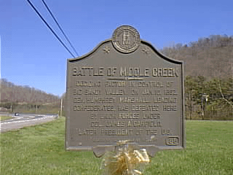
Marker No. 85.
State Route 114
1 mile west of Prestonsburg, KY
Deciding factor in control of Big Sandy Valley. On Jan. 10,1862, Gen. Humphrey Marshall, leading Confederates, was defeated here by Union forces under Col. James A. Garfield, later President of the U. S. For a larger image, click here
 |
Marker No. 151
State Route 404
David, KY
Discovered by Daniel Boone and one or two companions while exploring Eastern Kentucky, winter 1767-68. Later called Young's Salt Works. These springs provided salt for pioneers in the valley and for troops on both sides during the Civil War. For a larger image, click here.
 |
Marker No. 164
US 23 & 460
South of Prestonsburg, KY
This marker has been removed for repairs. Photo courtesy of John Wesley Hall.
Site of first important Civil War engagement in Big Sandy Valley, November 8, 1861, when Confederate forces led by Captain Andrew Jackson May were defeated by Federal troops under General William Nelson. For a larger image click here
Marker No. 172
Prestonsburg, KY
Used by Colonel, later President, James A. Garfield as his headquarters following Battle of Middle Creek, January 10, 1862.
 |
 |
Marker No. 623
S Arnold Ave. & State Route 114
Prestonsburg, KY
On tragic last Kentucky raid CSA Gen. John H. Morgan and Raiders entered state June 1, 1864, took Mt. Sterling June 8, lost in on 9th, took Lexington on 10th, and Cynthiana on 11th. USA under General S. G. Burbridge defeated CSA next day. Morgan retreated through here, reaching Virginia June 20. See map on other side. Raiders never recovered from this reverse.
Marker No. 690
Jct. US 23 & Mare Creek Rd.
Founded, 1796, by Solomon Stratton, veteran of George Rogers Clark's expedition to Illinois, 1778. In Virginia milita, 1783. In 1788 he and son explored this region. Eight years later, he and kinsmen from Virginia settled here. In 1797, he, Matthias Harman, Andrew Hood, laid out Prestonsburg for Col. John Preston. Stratton died 1819, unmarked grave, 500 feet east.
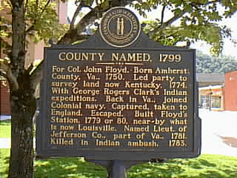 |
Corner of S. Central Ave & Court St.
Prestonsburg, KY
For Col. John Floyd. Born Amherst County, Va., 1750. Led party to survey land now Kentucky, 1774. With George Rogers Clark's Indian expeditions. Back in Va., joined Colonial Navy. Captured, taken to England. Escaped. Built Floyd's Station, 1770 or 1780, nearby what is now Louisville. Named Lieut. of Jefferson Co., part of Va., 1781. Killed in Indian ambush, 1783. For a larger image, click here.
 |
Marker No. 905
Jct. US 23 & Mare Creek Rd.
In 1845, Ky. Legislature put Mare Creek farm of Tandy R. Stratton in Floyd County. In Pike since it was formed from Floyd, 1821. Strip separates farm area from Floyd, forming "island" in Pike. Reported to be the only instance in U. S. His grandfather set up Stratton Settlement, 1796, at mouth of Mare Creek and with two others directed laying out of Prestonsburg, 1797. For a larger image, click here.
 |
Marker No. 2018 Side 1
Front of Samuel May House, North Lake Drive
Prestonsburg, KY
Built in 1817 by Samuel May, this is the oldest house in Prestonsburg. It was constructed of bricks manufactured at the site. The 350~acre farm, with its grist mill, was a recruitment and supply post for Confederates during Civil War. The house was restored in 1997 by the City of Prestonsburg and Friends of Samuel May House, In.c Presented by Burl Spurlock Family. For a larger image, click here.
 |
Marker No. 2018 Side 2
Son of Revolutionary War Veteran John May and Sarah Phillips May. Samuel settled in Prestonsburg around 1807. Commissioned to build county's first brick courthouse in 1815. Elected state senator in 1836, he proposed improving a critical road in Eastern Ky., the Mt. Sterling Pound Gap Rd. He died in California during gold rush. Presented by E. Carter & P. Hughes Families.For a larger image, click here.
© 1999 - 2004shatcher@mikrotec.com