
Trail Running in Orange County
| Home | Tips | Trails (text) | Trails (with 6Kbyte clickable map) | Other Resources |
Trail Running in Orange County
| Home | Tips | Trails (text) | Trails (with 6Kbyte clickable map) | Other Resources |
|
 |
|
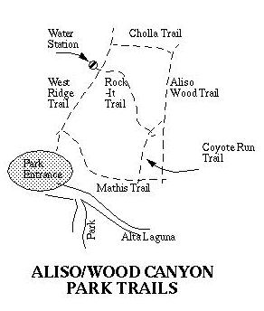 |
 West Ridge Trail Mathis Trail
This is a very steep but wide trail. No brush interference problems. It's also quite straight and long. Once it reaches the bottom of the canyon it curves a bit around the side of a mountain until it reaches a stream crossing. In front of the stream crossing is Coyote Run Trail. After the stream crossing it dead-ends into Aliso Wood Canyon. (Signs up for both trails)
Rock-It TrailThis is a very long trail with a variety of characteristics. Part of it is a hill of rock (fun to climb!), part of it is very curvy, part of it is VERY narrow with lots of tall brush (4 to 5 feet). If you don't have long pants you may not want to take this (same with long sleeve t-shirt). You can probably walk it okay but you definitely will have brush interference running
Keep in mind that this is a favorite of lots of mountain bikers..and keep in mind this trail is narrow with lots of blind spots
Cholla TrailLots and Lots of curves. Also very short. This is supposedly the easiest way to go up to West Ridge from Aliso Wood Canyon (keep that in mind for your runs!)
Though you probably won't have brush problems, you'll want to watch your step!
Aliso Wood Canyon TrailFrom the middle rung (Coyote Run/Rock-It) to the top rung (Cholla) it winds and rolls through lots of trees (THIS IS MY FAVORITE PART!)
The bottom part (between Mathis and Coyote Run) may be washed out after hard rains. If this is the case, there is a singletrack about 5 to 10 feet off the main Aliso Wood Canyon Trail which you can take to make your way through. Park rangers usually mark it with bright orange flags. If you need to take this singletrack, realize that it's quite narrow with some high brush (3 feet) at times.
Coyote Run Trail
The Coyote Run Trail has some spots of brush interference. The brush is short and the spots are not many.
Being on the side of the mountain, it curves and winds through some trees.
Reasons why I like using this trail:
You will have some interfering brush here and there..not very tall, just at the legs if anything. It's a fun trail to go on though!
Start on the WestRidge Trail (where else?)...
after the first dip, you'll come to a large fork. The WEstRidge Trail heads left, the Mathis Trail goes straight. Take the Mathis Trail
STEEP STEEP STEEP! watch your step. I choose this direction because it would be a killer to go back up...
Right before the stream crossing, head left on the Coyote Run Trail
You will eventually come to a large clearing.. to the left is the Rock-It Trail.. straight(sort of right) the Coyote Run trail continues... keep continuing on Coyote Run
Another 200 feet and you will meet the Aliso Wood Canyon trail..go left
Go through lots of curves, turns, and forest until you come to a large clearing and a sign. To the left is Cholla Trail.. take it
Cholla has lots of crazy turns ..it's very fun to go up! And because of the crazy turns you probably won't realize you are going uphill.. Much easier to go up this hill than Mathis..thus the direction we are going
At the top, you will reach WestRidge. Go left (can't go anywhere else)...
It's a long tough up and downhill battle but you have maybe 2 miles left..the last uphill is a killer! but realize your car and the water fountain is waiting..
Hope you brought some goodies to eat!! Enjoy the view!
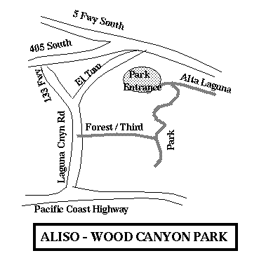
| Home | Tips | Trails (text) | Trails (with 6Kbyte clickable map) | Other Resources |
These freaky Geocities people are giving out Free Home
Pages...what's
the world coming to?