Icono Clast
Maps of San Francisco and environs
Table of Contents
MAPS
San Francisco Downtown Golden Gate Park The Presidio 49-Mile Scenic Drive Region
The excellent, and very useful, CITY-WIDE San Francisco Municipal Railway map.
City-wide map best when enlarged 150% or greater. Changes of April 7, 2007, not shown.
San Francisco BIKE Map & WALKING GUIDE
is as good as the above but has color-coding (key at SouthEast corner)
indicating the steepness of our streets. It also shows what's where. It's a great map!
Bike map best when enlarged 200% or greater.
San Francisco MUNI map of
DOWNTOWN, SOUTH o' the SLOT, and TREASURE and YERBA BUENA islands.
Downtown map best when enlarged 150% or greater. Changes of April 7, 2007, not shown.
From The Bay to approximately Arguello Boulevard to Mission and Sickles
showing T-THIRD STREETCAR LINE but few streets.
Best when enlarged 200% or greater, showing changes of April 7, 2007.
CABLE CAR ROUTES
with routes of Telegraph Hill/Coit Tower bus, Market/Wharves and Embarcadero streetcars
How to get There! from Where? via the San Francisco Municipal Railway.
A superb map of GOLDEN GATE PARK
CAVEAT: Don't look at it unless you have some time to play with it!
Map of the PRESIDIO
©John Collier's inaccurate-but-nice TOPOGRAPHICAL map.
Several Districts are not identified on the above map. [Islais Creek incorrectly labeled as "Island Creek Channel"]
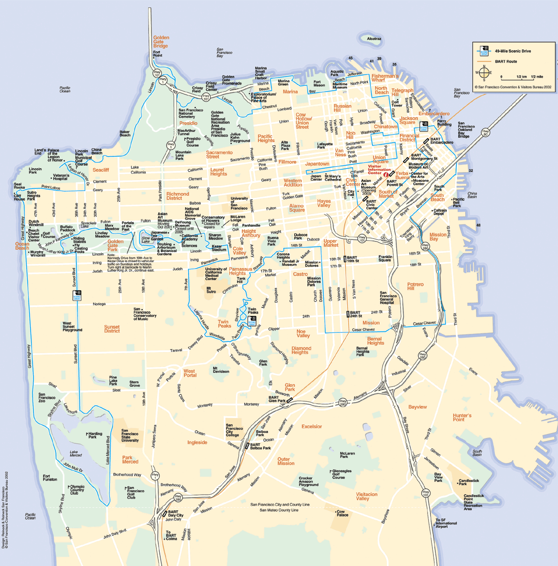
©San Francisco Convention & Visitors Bureau inaccurate-but-clear map of San Francisco with
Blue line = 49-MILE SCENIC DRIVE.
Unidentified Districts include Eureka Valley, Parkside, Saint Francis Wood, others;
part of Excelsior mis-labeled as "Outer Mission"; “San Francisco County Line” is in Crocker-Amazon.
Two maps of San Francisco and eight nearby counties.
REGIONAL MAP
with the bays San Francisco, Bodega, Drake's, Grizzly, Half Moon, Monterey, Richardson, and San Pablo.
If MY FLAG isn't displayed below, click here.

Motto in Scroll: Oro en Paz, Hierro en Guerra — Gold in Peace, Iron in War
If nice flag not displayed above, click here for not-so-nice flag.
Top of Page

The Presidio of San Francisco — ©National Park Service
Top of Page


Top of Page

Many towns not shown on this map of the
San Francisco, Bodega, Drake's, Grizzly, Half Moon, Monterey, Richardson, and San Pablo bays.
Maps of San Francisco and environs
Table of Contents
MAPS
San Francisco Downtown Golden Gate Park The Presidio 49-Mile Scenic Drive Region
The excellent, and very useful, CITY-WIDE San Francisco Municipal Railway map.
City-wide map best when enlarged 150% or greater. Changes of April 7, 2007, not shown.
San Francisco BIKE Map & WALKING GUIDE
is as good as the above but has color-coding (key at SouthEast corner)
indicating the steepness of our streets. It also shows what's where. It's a great map!
Bike map best when enlarged 200% or greater.
San Francisco MUNI map of
DOWNTOWN, SOUTH o' the SLOT, and TREASURE and YERBA BUENA islands.
Downtown map best when enlarged 150% or greater. Changes of April 7, 2007, not shown.
From The Bay to approximately Arguello Boulevard to Mission and Sickles
showing T-THIRD STREETCAR LINE but few streets.
Best when enlarged 200% or greater, showing changes of April 7, 2007.
CABLE CAR ROUTES
with routes of Telegraph Hill/Coit Tower bus, Market/Wharves and Embarcadero streetcars
How to get There! from Where? via the San Francisco Municipal Railway.
A superb map of GOLDEN GATE PARK
CAVEAT: Don't look at it unless you have some time to play with it!
Map of the PRESIDIO
©John Collier's inaccurate-but-nice TOPOGRAPHICAL map.
Several Districts are not identified on the above map. [Islais Creek incorrectly labeled as "Island Creek Channel"]
©San Francisco Convention & Visitors Bureau inaccurate-but-clear map of San Francisco with
Blue line = 49-MILE SCENIC DRIVE.
Unidentified Districts include Eureka Valley, Parkside, Saint Francis Wood, others;
part of Excelsior mis-labeled as "Outer Mission"; “San Francisco County Line” is in Crocker-Amazon.
Two maps of San Francisco and eight nearby counties.
REGIONAL MAP
with the bays San Francisco, Bodega, Drake's, Grizzly, Half Moon, Monterey, Richardson, and San Pablo.
If MY FLAG isn't displayed below, click here.
Motto in Scroll: Oro en Paz, Hierro en Guerra — Gold in Peace, Iron in War
If nice flag not displayed above, click here for not-so-nice flag.
Top of Page
The Presidio of San Francisco — ©National Park Service
Top of Page
| SAN FRANCISCO BAY AREA's nine counties | Many towns not shown on map above |
Top of Page
Many towns not shown on this map of the
San Francisco, Bodega, Drake's, Grizzly, Half Moon, Monterey, Richardson, and San Pablo bays.