  |
~ Roman Monographies ~
Aqueducts · part III · PAGE 1 |
  |
|---|
WHAT CAN BE SEEN TODAY
| |
~ Roman Monographies ~
Aqueducts · part III · PAGE 1 |
|
|---|
The only fragment that can be seen in central Rome consists of four white travertine arches belonging to the Aqua Virgo, below the present street level and interred for most of their height, located between the buildings in via del Nazzareno, not far from the Trevi Fountain. In over twenty centuries the ground level has considerably risen, up to the point of matching the top part of the buried aqueduct.
series of arches of the Aqua AlexandrinaOn the same spot, a tiny doorway topped by the crest of Sixtus IV (1471-84), conceils a passage that leads to the actual duct of the Aqua Virgo. The passage is still in use for maintainance works, but for obvious reasons it is kept closed, at all times.
the buried arches of the Aqua Virgo, in central Rome
The purpose of this page, instead, is to point out the few but interesting remains in the modern suburbs, still within the modern urban boundary, yet well off the "official" tracks beaten by the tourists.
the passage leading
to the Aqua Virgo's ductRunning the mouse cursor over the pictures in this page, the specific location of their subjects will be shown.
arches of the Aqua Claudia
Also earthquakes and wars took part in damaging these structures; this gives reason for the very few remains now left within the ancient urban boundaries.
Some interesting parts, though, can be seen in the southern and eastern districts, areas now densely populated, which no longer than a century ago were countryside.
For practical purposes, they are grouped and described according to their location.
| PAGE 1 AQUEDUCTS BY THE CITY GATES |
PAGE 2 FROM THE SPES VETUS TO THE TUSCOLANO DISTRICT |
PAGE 3 THE AQUA TRAIANA AND THE AQUA ALEXANDRINA |
|---|
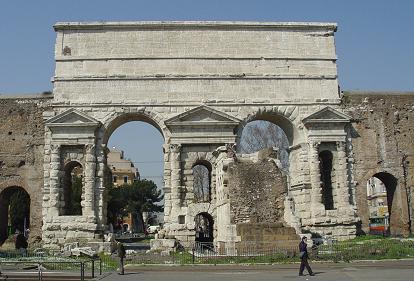
Before becoming the main south-eastern city gate of Aurelian's wall (3rd century AD), Porta Praenestina, now called Porta Maggiore, was an arch of the local aqueduct. The same can be said of the next eastern gate, Porta Tiburtina (see also Aurelian's Walls, part II, page 1 and page 2 for details and further pictures).
Porta Praenestina today: two ducts ran above its arches
The area just before Porta Praenestina was the Spes Vetus, see part II, where five different "waters" converged (actually six, including the underground course of the Aqua Alexandrina, although its duct has never been found). They conveyed over 70% of Rome's total water supply: the following diagram shows the direction of these aqueducts according to archaeologist R.Lanciani (late 19th century), although the graphic 3-dimensional elements have been taken and adapted from E.Du Perac's map of ancient Rome (1576).
It also shows which parts Sixtus V reused for his Aqua Felix (in brackets), which ancient parts are still standing, coloured in tan, and which ones are lost, in light grey.
 the net of aqueducts in south-eastern corner of Rome: the names of the ancient sites are in black, in blue are the present ones, and the dots are modern railway lines |
The Aqua Marcia, Tepula and Iulia followed Aurelian's wall,
pointing towards Porta Tiburtina. Before reaching the gate, the Aqua Marcia gave off an important branch
called the Rivus Herculaneus, which might have likely served the nearby nymphaeum
of the Licinii family, more commonly known as Temple of Minerva Medica
(see Aurelian's Walls, part 2
page 3). |
|---|
The Rivus Herculaneus carried water to the Coelian Hill, in the south of republican Rome, and then ran underground, parallel to the earlier Aqua Appia, reaching the Aventine Hill (south-west). Nothing of this branch has survived, except segments of the underground duct.
By Porta Tiburtina the aqueduct diverged from Aurelian's wall, following its own viaduct and pointing towards the Quirinal Hill, i.e. northbound. In the late 16th century, this became a part of the newborn Aqua Felix.
In the late 1800s, though, due to the making of the nearby Termini Station, every part of the viaduct beyond this spot was taken down. Only its first 100 metres (or yards) were left standing; they end with an arch celebrating Sixtus V, now adjoining the railway's precincts in piazzale Sisto V.
Instead the Aqua Claudia and the even richer Anio Novus shared the same main output, located very close to Porta Praenestina, although the last remains of their castellum disappeared in the late 1800s.
the Arcus Neroniani, or Arcus Caelimontani
When the Golden House was dismantled, the branch was altered to reach the Coelian and Aventine hills, and renamed Arcus Caelimontani, i.e. "arches of the Caelimontium", ancient Rome's second district, which included the Coelium and its minor reliefs (see also The 22 Rioni). this caused the aforesaid Rivus Herculaneus to become obsolete.
A further extension of this branch for the Palatine hill, in central Rome, was built by emperor Diocletian (late 3rd century).
 above: the church of S.Stefano Rotondo, in a 17th century map of Rome; the remains of the aqueduct, that mark the church's precincts, are still standing today (right) |
 |
|---|
the Arch of Dolabella and Silanus
Just past the church, a few tall arches of the aqueduct touch the site where once stood Porta Caelimontana, one of the gates belonging to the set of Servian Walls (4th century BC). In 10 AD two consuls, mentioned in an inscription above the archway, altered the passage into its present shape; after their names, this is still known as Arch of Dolabella and Silanus.
Curiously, inside one of the aqueduct's pillars are two rooms, in which St.John de Matha (1160-1213), founder of the Order of the Trinitaries, or New Crusaders, dwelt for two years.
Since in ancient Rome this was a rather busy district, secondary branches of the Arcus Caelimontani very likely carried water to the fountains of the Circus Maximus, to the establishments that stood along the banks of the Tiber, that runs by the opposite end of the stadium, and so on.
the aqueduct in via Turati
Once believed to be a branch of the Aqua Iulia, from the height of its specus now scholars mantain that it might have been reached either by the Aqua Claudia or by the Anio Novus.
one of the two "Trophies", now at
the top of the Capitolium's steps
the remains of "Marius' Trophies",
likely reached by the Aqua Claudia or Anio Novus
In recent times, though, the "trophies" have been found to be less old, dating to the late 3rd century AD, which means that they had been probably taken away from some other monument or statue.
In the late 16th century, pope Sixtus V had them removed from the remains of the fountain, and relocated on the Capitolium Hill, at the top of the flight of steps drawn by Michelangelo (a description and pictures of the site can be found in The 22 Rioni and Capitolium Square).
Just past Porta Tiburtina, the triple aqueduct's course made a westward bend, diverging from the straight line followed by the city walls (actually, it would be correct to say that the walls diverged from the aqueducts, since the latter were built earlier). From this spot the aqueducts ran to their water castles, located somewhere in the northern part of Rome; one of them probably stood by the Baths of Diocletian. What we see today on this spot, though, is the late 16th century viaduct built under pope Sixtus V, who took advantage of the ancient roman structures, still partly standing, and literally recycled them for the making of his project, the Aqua Felix, whose main output, or "display" fountain, was built some 350-400 metres or yards off this spot (see part III page 2 and Fountains part III page 6 for further details).
the archway of Sixtus V, just before the station (on the left)
Fortunately, the spared stretch includes the "special" double-sided archway that Sixtus V had built on the spot where travellers coming to Rome along via Tiburtina would have likely crossed his Aqua Felix.
the archway's inscription (1587)SIXTUS V POPE But nothing is left of the fountain that once stood by this archway, and welcomed the thirsty travellers who entered Rome from the east.
BUILT AT HIS EXPENSES
THE DUCT OF THE AQUA FELIX
BY UNDERGROUND FLOW
FOR 13 MILES,
BY ARCHWAY VIADUCT FOR 7
PAGE 2
FROM THE SPES VETUS
TO THE TUSCOLANO DISTRICTPAGE 3
THE AQUA TRAIANA AND
THE AQUA ALEXANDRINA