During the reign of emperor Trajan (
AD 98-117), despite nine aqueducts were already working, the district on the western side of the Tiber, Trans Tiberim, had been left without a supply of drinkable water. The only aqueduct that reached Rome from the north-west was the Aqua Alsietina; having been built with the main purpose of filling emperor Octavianus Augustus' naval stadium (see
Curious and Unusual
page 4), the water it drew directly from the small Lacus Alsietinus, now Lake of Martignano, was not suitable for drinking.
Trajan sought for clean springs in the same area, finding them by the hills
on the western side of the Lacus Sabatinus (now Lake of Bracciano).

the Aqua Traiana's course (dotted line) |
Minor springs
located on the eastern side of the lake were also used, so that the first
stretch of the aqueduct followed about half of the lake's perimeter.
The Aqua Traiana was completed in AD 109.
Trajan bought all the grounds crossed by the aqueduct, so that the
tunnel could always run through a 30 feet-wide protected area, from the lake
all the way down to Rome. Its tunnel was at ground level for most
of its course; approaching the city, though, some parts ran above a viaduct.
Small stone pyramids, set at regular intervals along the Aqua Traiana, marked
the openings of the tunnel's roof. |
The aqueduct entered Rome from the Janiculum,
and the final output was located at the very top of the hill, one of the city's
highest spots, where the Aurelian way approached Trastevere from the west,
and where Aurelia Gate was built around 275 (see also
Porta San Pancrazio).
The steep drop from the top of the hill to
Trastevere's plains could also provide hydraulic power to
the local mills.
The Aqua Traiana remained functional until in 537 the Goths damaged Rome's
aqueducts. During the Middle Ages it was reactivated several times, but it never
worked steadily again, until it was completely restored and partially rebuilt
in the early 17th century.
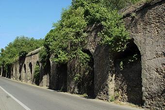
What is visible today within the urban area are three stretches of the
viaduct, belonging to its last mile before the final output.
They follow via Aurelia Antica, the modern road corresponding
to the ancient roman Aurelian way, still narrow in some parts,
and sometimes congested with traffic. |
 |

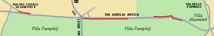
the red lines indicate the visible parts of the aqueduct
Along the first part, i.e. the one once closer to the final output, the viaduct reaches its maximum height, about 6 metres (or yards), not very tall, compared to other aqueducts.

the commemorative archway of Paul V |
This stretch of the Aqua Traiana marks the boundary of a large
public park, Villa Pamphilj; once this was the suburban residence of the Pamphilj
family, whose most outstanding member was pope Innocent X (1644-55).
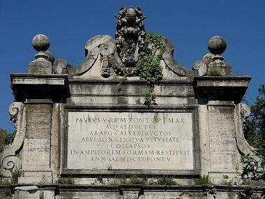
Where via Aurelia Antica makes a slight bend, the aqueduct crosses
the road thanks to an archway, whose look is clearly not ancient roman.
Pope Paul V had it built in 1612, when the Aqua Traiana was restored;
in the upper part of the archway, his commemorative plaque
and family crest remember his sponsorship. |
The text, though, reveals
a curious mistake: according to the third line, that reads
AB · AVG · CAES · EXTRUCTOS ("built by emperor Augustus"), the pope and his architects wrongly
believed that what they had just restored was the Aqua Alsietina,
actually built by Octavianus Augustus for his naval stadium, not the
Aqua Traiana. The same mistake is also found in the even larger
inscription above the huge Fountain of the Aqua Paola (see The 22 Rioni,
Rione XIII - Trastevere). |
detail of Paul V's commemorative plaque |
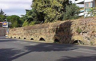
On the right side of the road (walking westwards), the viaduct gradually
turns lower and lower, until the series of arches disappears quite abruptly.
Very soon the road goes slightly uphill, then downhill again; immediately
past this spot, the viaduct appears again, on the southern side of the street.
Extremely low at first, it grows gradually higher until it acts once again
as a boundary wall of Villa Pamphilj; in fact, the main
entrance to the park is located below one of the viaduct's arches.
The last part of this stretch is barely recognizable, because the brick texture of the viaduct has been covered with plaster, and appears smooth, as an ordinary wall. Then, by a crossing, the Aqua Traiana comes to an
end again.
the third visible part of the viaduct |
The third part stands about 200 metres or yards further west, by the crossing with via del Casale di San Pio V, next to
a block of modern buildings. The viaduct can be told by the series of arches, whose uppermost part emerges from the ground for about 1 m (3 ft),
remaining very low. Here the visible part of the structure is no more than 3-3.5 metres or 10 feet high, and it corresponds to the
actual water tunnel, whose average height (inside) was about 2 metres or 6 feet. |
On the corner where the viaduct makes a bend, turning towards the north-west, a surviving pyramid rests above the tunnel's roof.
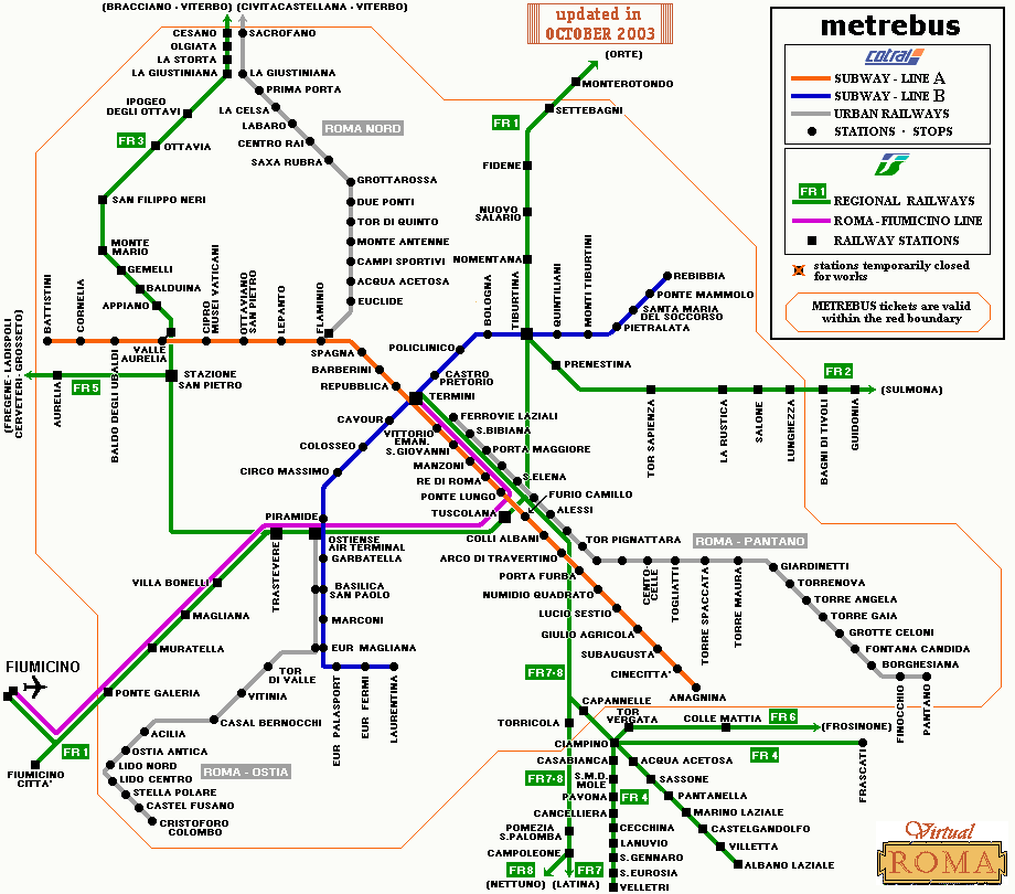
The best way to reach the remains of the Aqua Traiana is to walk from San Pietro station (bus 64, or regional railway FR3) along via delle Fornaci, to the crossing with via Aurelia Antica (but mind the traffic!). Also the bus line 31 stops along
via Leone XIII. Other public transport facilities can be reached following via del Casale di San Pio V: from the end of this road, the bus stops of lines 490 and 495 are 300 m or yards ahead, while 500 m or yards ahead is the nearest subway station, Cornelia (line A).
|

the only surviving pyramid of this stretch of aqueduct
|
THE REMAINS OF THE AQUA ALEXANDRINA
The Aqua Alexandrina was the last aqueduct built in ancient Rome, in
AD 226, over 500 years after the first one. Its purpose, according to emperor Alexander Severus who was the sponsor, was to carry water to the Baths of Nero, which stood in the western part of the Campus Martis, more or less where today is piazza Sant'Eustachio (see The 22 Rioni,
page 8).
 |
The new aqueduct drew water from springs located east of Rome,
as most previous ones did, and shortly before approaching the city walls it turned into an underground channel,
and entered the urban area by Porta Praenestina (now Porta Maggiore); from here
it likely followed the Esquiline hill, then the Quirinal hill, finally sloping down towards
the plains of the Campus Martis. |
|
None of its urban parts has been left standing, and the same aforesaid course
is partially hypothetic because the underground duct has never been found. Instead, two long parts of
the viaduct can be seen in the suburbs, while off the modern city's boundary the aqueduct
is still in rather good condition for most of its length.
The first surviving part is located in viale dell'Acquedotto Alessandrino,
where an unbroken series of arches stretches for 250 m (or yards) through a public
garden. Their direction seems to be pointing towards via del Mandrione, described
in part III page 2, not far from this spot. In fact, also the Aqua Alexandrina approached the city following the
common route shared by the Aqua Claudia, Anio Novus, Aqua Marcia, Aqua Tepula and Aqua Iulia. |

the Aqua Alexandrina by Tor Pignattara district |
Not far from the south-eastern end of this part of viaduct, another interesting and not too
famous ancient remain can be seen in via Casilina: the monumental tomb of St.Helen, mother of emperor
Constantine the Great, who died in 328 AD. It consists of a round
hall built in bricks, with a tall dome (collapsed a long time ago), which stood by the
entrance of a Christian underground cemetery, or catacomb, named after the saints
Marcellinus and Peter.

the tomb of St.Helen, or Tor Pignattara (above),
and a detail of a few pots left in the vault

|
The inside has eight niches all around the hall; one of them matches the entrance,
while the large sarcophagus in which St.Helen's body was buried, made of red porphyry
(a marble only used for imperial family members), now kept in the Vatican Museums,
stood in the largest niche, opposite the entrance. The central space of the hall is now
occupied by a tiny church, SS.Marcellino e Pietro, built in the early 17th century.
According to a particular technique in use by the late imperial age, the weight of the
dome was reduced by inserting earthenware pots or amphors in the building material; a few of
them are still there. This was worth St.Helen's tomb the popular nickname of Tor Pignattara
(more or less "pot tower"), which also became the name of the whole district. In ancient
times, instead, this site used to be called ad duas lauros ("by the two laurels"),
because of two laurel trees planted by the large tomb, a symbol meaning that the building
belonged to the imperial family. |
The second standing part of the Aqua Alexandrina is about 1 km (0.65 miles)
further east, at the southern end of another popular district, Centocelle.

the Aqua Alexandrina by Centocelle district
This stretch has more or less the same length as the previous one, but the brick texture of the pillars is
better preserved. Luckily, the large and busy road that passes below its central part,
viale Palmiro Togliatti, does not affect at all the surviving structure.

the floor of the uncovered specus |
On this spot the pillars of the Aqua Alexandrina reach their maximum height, over 20 m (about 65 ft),
because here the viaduct crossed a ditch, still partially recognizable from the sloping
street that now follows the series of arches.
Towards both ends of this fragment the pillars become gradually lower, particularly
on the left (i.e. towards Rome), where the modern ground level, much higher
than in ancient times, soon reaches the top part of the structure,
and completely buries it. Here the specus is quite poorly preserved:
the only existing part is its floor, or bottom, which remains uncovered for a few metres or yards.
But it is interesting to see it in section: the waterproof facing,
almost 10 cm (4 in) thick, can be easily told from the rest of the texture
made of mortar and bricks. |
The aforesaid sites of the Aqua Alexandrina are located well off the
city center, but they can be easily reached by taking the urban train whose
terminus is in via Giolitti, by the southern side of the Termini Station (look for Ferrovie Laziali stop
in Rome's railway line map).
The closest stops to the aqueduct's remains are Tor Pignattara and Togliatti,
respectively. |

the long series of arches, pointing towards Rome |


