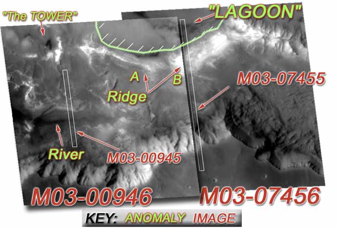
"LAGOON, RIVER & RIDGE "

RIVER
Anomaly:


MO3-00946 Coprates, wide-angle, presented previously under "The TOWER"
M03-07456 Coprates, wide-angle, overview of "Lagoon" and Ridge.
M03-07455 narrow-angle, detail of "Lagoon" and ridge structure. At least 9 equilateral conical shaped "teeth" pointing upwards within the fluid body.
M03-00945 narrow-angle, detail of the "river" fluid body and Dome structure on North bank with spiral ramp descending from top.

Description:


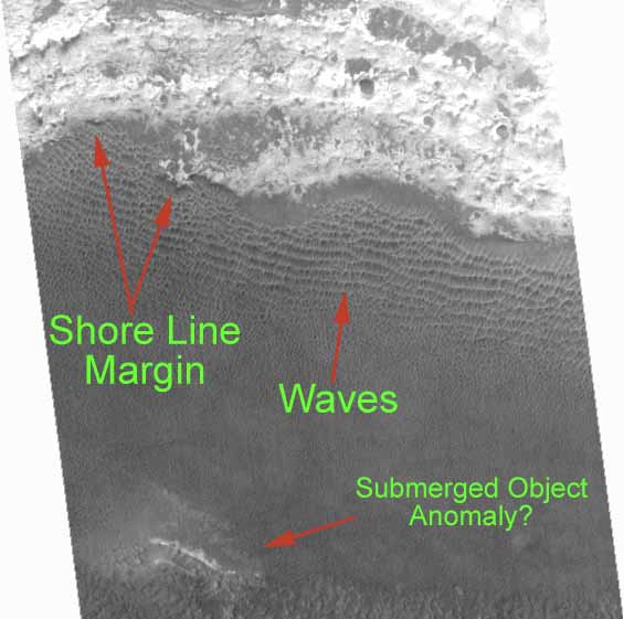
East of "The TOWER" <presented previously> there is an artificial ridge serving as a berm to a WATER FILLED LAGOON with anomalous bizarre triangular "teeth" beneath the surface!! Also there is a flowing river cascading over a waterfall into a deep pool and flowing beyond!

Discovered by:


"Mars UnEarthed" & Tripp McCann. 7/2/00, Presented 8/9/00

*NOTE *-  In viewing any of the MOC imagery in detail,  it is recommended you download sinusoidal projected 'losless GIF" for any given image footprint. These GIF images at times are so large that browsers cannot display them and they should be downloaded by right clicking the link and choosing "save as.."


"LAGOON & RIDGE"
Image Map

"The TOWER""The LAGOON"RidgeRiverM03-07455M03-07456M03-00946MO3-00945

River

Description

After discovering the "Lagoon" I searched the images and found the clear evidence of a river. Initially I thought the river was only a paleo river bed, now dry. However on closer inspection I was able to make out the clear boundary lines of the river itself even outside the deeper river channel and how these lines of the water darkened and blurred the topographic detail within and beneath the fluid surface. The River runs east/west in the image M03-00946 just north of the talus cones and a portion of the river is revealed by the narrow-angle image M03-00945 which clearly shows the river and the channel banks and fluid forms of indicating it is a flowing body of "water". Also up slop from the River's northern bank there is a portion of a dome with a spiral ramp leading circling down from its top to ground level.


The image below is a magnified portion of M03-00946 wide-angle image. The image has the portions of the river margins delineated by green dots as well as other labeled details.


You can note the white staining on some portions of the bank just outside the margins of the river itself. I believe this white staining to be mineralization from repeated evaporation of water as the river rises and falls periodically. This staining is more prevalent as the river gets further away from the waterfall and the deep pool beneath as the river gets shallower. This area also shows meanders in the main river bed bottom, showing that the incline of the topography in this area is lessened.

Other details of the River are revealed in the narrow-angle image M03-00945. The boundaries of the river, the shore line and the river channel are revealed below. Click on the image for a larger full-scale image.


M03-00945 Shore Line Detail. <CLICK for lager image including the ramped dome.>

The River and objects such as boulders in the river show characteristics of fluid water bodies. The Rivers shows small waves along the banks as the bottom becomes shallower rising to become the bank. Similarly the shoals across the river over sand bars exhibit waves over them. Objects within the river body show diminishing clarity of line and form with depth as a result of suspended sediment and possibly dissolved minerals as well.  There is strong evidence of mineralization from repeated evaporation along the river banks, evidence that River is not a recent form on the Martian topography but one that has known repeated changes of fluid level.

Of note is a highly unique looking anomaly in the River itself. This anomaly has a unique curled shape with bounding "rails" and within these rails are a group of parallel rib structures. This object can be seen in the midst of the River detail as well as the lower left corner of the above image.


Fossil Or Structure?


This object is seen within the water body of the River in MO3-00945 narrow angle image.  The object is in a shallower area of the river and has a sand bar surrounding it. Was this object exposed by recent erosion or was it the cause of the formation of the sand bar around it, creating an eddy down stream and creating a less turbulent area where sediment did then settle? Beyond doubt the object's shape and structure makes one think of a biological skeleton of some enormouse beast. The object has 8 or 9 evident "ribs" coming down from a linear curved structure perpendicular to these ribs, which could almost be a "spine".  No known terrestrial skeleton would remain intact for long in a fluid flowing river invironment. Could this object be similar to "The Tubes" presented previously? Are these "ribs" actually exposed "arches" similar to those in the tubes? Is the clearly evident supporting structure perpendicular to the ribs some sort of structural roof support for the "Tubes" in underground structures? If this IS a "tube" or some similar structure, was it exposed by a more recent recurrence of fluids rising in the River area? There wearing away of the river sediment exposing the object and ribs on the upstream <left> side of the object facing the viewer is clearly evident.

Certainly if this is an exposed underground structure, it is supported by what the rest of this site implies about the existance underground structures, given the "The Tower" has no evident above ground source structure for its steam and that the Ridge area itself appears to be artificial due its layered construction with a metalic base structure.

Beyond doubt, at over 300 meters for the "spine" length and close to 140 meters for the length of the longest of the exposed "ribs", this structure is VERY large. I believe we are looking at some artificial structure which was underneath the river at one time, traversing across it. This structure has been exposed by the erosion of the of river bottom and deepening of the channel. The sand bar surrounding the object and downstream from it is a result of the objects endurance despite the water currents, creating an calm eddy downstream allowing the deposition of sand material, creating the shallow sand bar area within the river channel.

The presence of this structure hints at the possible presence of further undergound structures traversing the entire anomaly area encompassed by the "Tower", "Lagoon", ridge and river.


The Ramped Dome Anomaly

North of the River in the narrow-angle profile M03-00945 there is a dome feature which would normally be without comment. However this dome has a spiraling ramp circling the outside of the dome and coming down from the upper dome level to the ground surface.  This Dome is seen in the northern portion of the detailed River image <HERE>. The Dome image is bisected by the left hand edge of the image and as a result the details of the remainder of this dome feature are unknown from this imagery.


This ramp coming from the dome has the appearance of having a concave, rounded bottom and, given the fluid associated with this area of Mars, could conceivably serve as sort of "sluice" for fluid discharge The detail of the unseen hemisphere of the dome available in MO3-00946 is inadequate to discern further structure. Whether this dome and declining circular ramp have some natural explanation, perhaps as a result of volcanic flow or erosion from a periodically fluid artesian spring source is uncertain. <Conceivably the "Lagoon" area could provide a hydrologic up-gradient source to fuel an artesian flow which might become periodic dependant upon the Lagoon's fluid level.) However, there are no evident volcanic forms nor erosional characteristics evident within the imagery. The ramp is of such a scale and unform width as it descends with the ramp uniquely circling the outer margins of the dome structure, that it is highly unlikely to be a natural structure. However, this is just rampant speculation <pun intended>. This Dome feature and ramp will remain a more enigmatic Martian feature until more information can be obtained.

Conclusion

This imagery clearly shows a definative fluid, flowing River and river morphologic forms like a waterfall, deep pool, defined main flow channel and river meander curves. The source and destination of the river fluids itself remain uncertain. Two very unique anomalies are evident, one within the river and the other upslope on the northern bank. The mere presence of this fluid filled River and the similrly fluid filled "Lagoon" is stunning. Exact chemical makeup of this liquid is uncertain: either the fluid body has a chemical makup different from water, H2O, or NASA has not been entirely honest abuot the temperature conditions on the Martian surface. Mars is reputed to have a permafrost as deep as 3 miles. These fluid bodies should not exist! Yet they do and NASA has conspicuously failed to comment on them, instead offering only imagery of trickles and seeps as evidence of the presence of water in recent geologic history. There is a major discrepancy betweenn NASA's behavior and acknowledgements and the evidence in the imagery.

"LAGOON"

Ridge