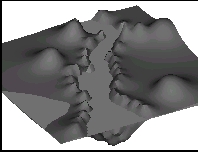
This
useful application can easily produce 3D contour maps and cut-sections
from a few data. You get a 3D-mesh AutoCAD entity and from this point,
you can make renderings to use in presentations and level lines visualization.
The application draws automatically selected cut sections over the 3D model
or in a 2D representation. Besides, the application calculates the volume
between the surface and a specified horizontal plane.
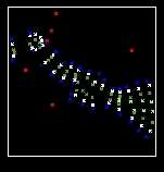 A
set of drawn points is required as unique data. These points have to correspond
with the field level survey.
A
set of drawn points is required as unique data. These points have to correspond
with the field level survey.
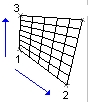 The
user defines the density and the corners of the mesh and the application
draws automatically the contour. The application draws the 3D mesh by using
an interpolation function, which takes in consideration all the data points.
The
user defines the density and the corners of the mesh and the application
draws automatically the contour. The application draws the 3D mesh by using
an interpolation function, which takes in consideration all the data points.
the drawing