![]()
![]()
| Return to the "Put-in" (Home page) | Format of descriptions | Disclaimers |
| RIVER: | Carp River |
| LOCATION: | 4 miles S. of Marquette, Michigan |
| AMENITIES: | Click for Michigan Amenities (food, lodging, etc.) |
| PUT-IN: | Base of Carp River Basin Dam |
| ALT.PUT-IN: | Marquette Mountain Ski Area Parking Lot (shorter 'easier' trip) |
| TAKE-OUT: | Hwy.28/41 |
| SHUTTLE: | South on Hwy.41/28 about 2.3 miles to 551, right (S) 1.8 miles, right
(W) on 480 about 6.4 miles to access road for Carp River Basin Dam, right,
bearing right at fork to proceed to dam.
-or- North on Hwy.41/28 about 1.4 miles, left on 553 toward Marquette Mountain Ski Area (approx.2.0 miles, where you can check flow). Continue another 3.5 miles to junction with 480. Right (W) 3.0 miles to access road as above. |
| DIST: | 5.1 miles (2.6mi upper, 2.5mi lower) |
| TIME: | 3.0 hours |
| CLASS: | II-IV+(V) (upper), II-III (lower) |
| CHARACTER: | Remote, mossy canyons, sliding falls (upper section only), continuous technical bedrock/rock-garden |
| GRADIENT: | Average: 111fpm (147fpm upper, 73fpm lower); Maximum: 210fpm upper, 101fpm lower |
| GAUGE: | Visual of rapids at put-in and/or downstream of culverts near Marquette Mountain
Ski Area. If it looks boatable, go for it.
We also 'gauge' the amount of flow coming out of the 'pipe' at the put-in, and refer to water levels of "full-pipe", "half-pipe", etc. |
| SEASON: | Spring/rain. |
 Carry down a skree-filled slope to the put-in for this seldom run river. Water from above the dam runs through a pipe maybe 5' in diameter. The end of the pipe is angled up, and water spews forth, spilling 40' (? +/-) into the gorge at the base of the dam. With this backdrop, your action starts off quickly as the river twists right, then left through a Zig-Zag in a pushy class II-III start.
|
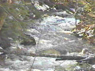 Numerous rocky rapids through technical class II paddling through this snag filled creek lead you to the main canyon, about 0.5 hour into the run. As the gradient noticeably increases, you'll want to be on the alert to get out and scout. River right may be best for close-up inspection of possible routes on some of the drops, though left is better for what is usually a quarter-mile or so portage. There is a trail (though not a great one) that mostly keeps you in sight of the river, but it tends to be difficult (much up-and-down) with a boat in tow. You may wish to scout without your boat, then (if portaging, which most will) head almost due north to a 4x4 trail, head east (right) a couple hundred yards to a small trail back towards the river. You can drop down a steep ravine to put in below the falls sequence.
|


|
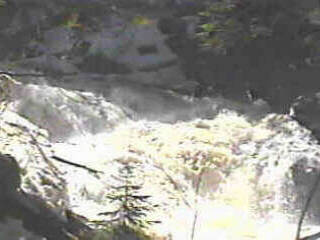
| The main falls (two views above) features a meaty hole flanked by shallow rock to either side. |
|
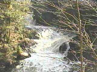
| Immediately out of the first drop, the flowing pool trips through another hole before spilling down a jagged ledge landing on more jagged rock. Above left photo shows the second and third pitch of this drop, while the right photo gives an 'overall' view. |


|
| Following the main drop, the river divides around a spline of rock (often littered with wood, as seen above left) and trips through shallow rapids to head toward another split ledge (above right). This is the end of the steepest gradient. |
Putting in below this canyon, one has a great continuous stretch of technical II+ scrambling. As one approaches Marquette Mountain Ski Area, the river splits into a couple of snag filled channels, none of which is likely to be boatable clear through. Suggested route: as soon as you see the ski area and the first snags, head ashore and go overland across the entire parking lot, to put-in just above (or below) the culverts at the highway. The gradient for the next 1.6 miles is a fairly uniform 90-100fpm, for a continuous class II-III boogie until it peters out into smooth but swiftly flowing water to the take-out. While this reach is generally not quite as technical as the "upper", snags are still a concern. Specifically, spring 2002 flooding washed out the culvert at this midpoint. Not far downstream, there is a river-wide tree/snag, just as the river does a zig-zag. A few minutes further, there is a river-wide logjam-dam sitting in a steep-banked stretch of river. The rest of the river was fairly snag-free (again, as of May, 2002). Note: Vidcaps (photos) are from "half-pipe" (moderate level) runs (1998.04.04 and 2002.05.13). |