![]()
![]()
| Return to the "Put-in" (Home page) | Format of descriptions | Disclaimers |
| RIVER: | Escanaba River, Middle Branch |
| LOCATION: | 7 miles S. of Ishpeming, Mi. (which is 12 miles W. of Marquette) |
| AMENITIES: | Click for Michigan Amenities (food, lodging, etc.) |
| PUT-IN: | carry in from gated road CR581 ("CR", I believe, means 'county road') |
| ALT.PUT-IN: | See second "alternate take-out" below. Using this as a put-in allows a short trip (2.5 miles or less, depending on take-out used) with 3-5 decent drops and fairly little flatwater. |
| TAKE-OUT: | Private property at Flopper Creek (if permission can be obtained). (Take-out is at mouth of creek. It is then necessary to 'bushwhack' a quarter-mile up the creek to an old double-track river-crossing, then upslope to the right to the gate and field/parking.) |
| ALT.TAKE-OUT: | CR565 (All land at 565 is private property; obtain permission from some property owner to park and take-out.)
(This access may omit 'Lower 5-6-5' and the final drop 'Homme Side/Sweet Side', and shorten the trip to 10.5 miles, -or- run these drops, carry back up around 'Homme Side/Sweet Side' and paddle back upstream (flatwater) to take-out.). |
| ALT.TAKE-OUT: | End of side road which branches west about 1mi. north of river on CR565. (Below 'Middle Finger', above 'Log Jam Island'.) Please be respectful of the private property which lies at the end of this road. On both occasions when we have encoutered the owners, they have been very friendly and co-operative about allowing river access.
(Taking out here will omit 'Log Jam Island', 'Boulder Garden', '5-6-5 Falls', 'Lower 5-6-5', and 'Homme Side/Sweet Side', and shortens the trip to 9.3 miles.) |
| SHUTTLE: | From the river, go north on 565. At 4.5 mi. bear left (NW) just after Schweitzer Creek, continue another 1.2 miles. Left (W.) on 476 (Co.Rd.PG), 7.5 mi. to 581, left (S.) 2.0 mi. to Co.Rd.CG, left (S.) 0.9 mi. to fork, left fork 1.2 miles, to fork, right fork 0.2 mi. to gate. (Back up to slight wide spot so as not to block road.) Either bushwhack east-south-east thru alder thicket or carry up road a hundred yards or so to access river. |
| DIST: | 11.5 miles |
| TIME: | 5.0 hours |
| CLASS: | II-IV |
| CHARACTER: | 'Lake/drop' (Same as 'pool/drop', but having l-o-n-g pools with little current); 12 good rapids with interesting variety; "Backwards" run, with the more intimidating drops first (generally); Slides, boulder gardens, and wicked (boof-able) falls. |
| GRADIENT: | 22FPM |
| GAUGE: | Visual. If the drop at the 565 bridge looks good, the run should be good.
U.S.G.S. gauge on Middle Branch is 16+ miles upstream, above the Greenwood Reservoir. A reading of 100cfs or more is a good indicator this reach will be running. |
| SEASON: | Generally good in spring or after heavy rain. Can be paddled for flatwater and scenery almost any (non-winter) time. |
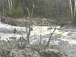
 Almost immediately from the putin, you will come to White City Falls (scout river-right). A very straight-forward, smooth bedrock approach leads to an irregular ledge. The left side of the lip is notched well back into a slot which looks very uninviting. The center and right drop off more cleanly into a large boiling pool. The bedrock is tilted such that this line is somewhat shallow, so there is some concern of 'grounding out' on this approach, especially at lower water levels. The rock wall in the pool below the boil on river-right appears to be undercut (perhaps as much as 2-3'), so utmost caution is urged if you do run this drop. While a clean run is easy, a flip or swim here could get ugly. At higer water levels, the hole here is ugly and it appears escape could be quite difficult.
|
 Note: the locals just label the successive drops by 'number' (2nd falls, 3rd falls, etc). I have taken the liberty of creating more descriptive 'boater names' for the drops.
About a half mile flat water leads to Second City Falls (scout right). The similarity to the first drop is interesting, though this is a bit bigger and a bit uglier. The river is squeezed through a couple decent wave/holes, then a short flowing pool before the main drop. The right side drops onto much irregular rock in the pool (hidden in the froth at higher flows), while the left has a large slab of rock at an awkward angle diverting the flow and causing a "hollow" face to the falls on that side. In the center of the lip, a wrapping wave spins off the face as the flow drops onto (and moreso behind) a rock buried in the flow. |
 Another half mile of mostly flatwater paddling brings you to Half Dome Falls and Granite Canyon. Scouting is done by carefully traversing the fairly steeply pitched right bank.
A flat rock (very near water-level at runnable flows) 'blocks' center-to-right of the approach. A ledge and a somewhat squirrely hole dump immediately onto a crown of rock, off which the water pours into slots to either side. Strong flow drives left-to-right, and tends to stuff boaters into the right slot. A pretty fair pool littered with boulders leads to the 'canyon'. |
 A sentinel of large rocks create pourover slots to form the entrance to about 40 yards of class III action through a bit of a squeeze in the river. Both times we've been here, there has been a log caught in the rocky left side of the river. A couple good holes form down the right side which always look bigger from in your boat than from the shore, but generally should cause no real problems. As with all drops on this river, there is a good pool below.
|
 Now the first "lake" begins, as you paddle almost 3 miles of mostly flatwater to reach the next good series, The Squeeze, Rock Island, and Play Waves. Get out on the right to scout.
The Squeeze is an obvious narrowing of the river where a short ledge forms a potentially sticky hole. You may wish to skirt the hole tight to the left side, likely bouncing off some rock in the process. |
 Just downstream, the flow is directed to the right by a huge 'island' of rock, off another short ledge/wave into a huge eddy. The river flows to the left out of the pool, over some shallow rock and ledges forming a couple of rolling waves. At good levels, these could provide boaters some entertainment (other than the length of the run usually precludes spending too much time or energy playing).
|
 Nearly a mile of mostly flatwater leads to Jumblewood Sluice (scout left (recommended) or right). The sluice on the right starts well, but ends in a jumble of shallow angular rocks which tend to accumulate sticks and strainers. To the left is a narrow sluice with a pair of ledge/holes leading to a slide into a wave/hole in the pool below. At higher flows, the "sluices" will substantially fill-in and this drop may be runnable almost anywhere, though the center is likely to stay scrapey at all but very high flows for this run.
|
 The next "lake" is about 1.8 miles (minor rips punctuate), before the next good action, Farmstead Warmup and Farmstead Falls.
The warmup is an easy class II rapids heading toward a clearing and house on river left. The river turns to the right and passes through some more easy boulderbed rapids before it slides down a large, open, sloping ledge into a large pool. Scouting is recommended (left is best). The left side of the slide ends a bit more abruptly, giving you a slight boof into the pool, while the center and right drop into a wave/hole at the base. The hole looks quite grabby at moderate to high water levels, though it has always been 'punchable'. The right shore/rocks extend well out into the pool (submerged at all but very low flows). Thus, while some play may be possible, the shallow shoreline-rock may make flips rather punishing, inhibiting your interest. |
 Paddle about 1.2 miles of flatwater to come to the next drop, Middle Finger (recommended scout left).
A short upper ledge forms a uniform hole center and right. Water flows onto a huge table of rock in the center of the river, splitting the main (~4') drop. To the left, a wrapping wave spins into a surging hole. To the right, a narrow thread crosses below the upper uniform wave and crosses in front of the table-rock to pass down the right side through two smaller, much more 'friendly' holes. |
Following this, you have the final long, flat paddle of almost 2 miles. About midway through this stretch is a possible access point near a house at the end of a dead-end road. This can be used as a take-out to shorten the trip or as a put-in for a short run on just the lower drops. The final drops are great fun (not nearly as challenging as the upper run) and come more closely together. A few minutes paddle from there will bring you to a short double-ledge drop. Current in the outflow slides along a wall of rock on the right. Just downstream, a small bedrock intrusion creates a pretty much riverwide riffle-wave which may also provide minor play before you arrive at Log Jam Island. Approach very cautiously, as even the relatively mild current can quickly push you into trouble here. Both sides of the island are prone to be blocked by wood, though the right has been clear the past two years. This route is almost a 'question mark' shape (starting from the 'top') as the river swings out in a sweeping round-about curve around the island. The left channel stays high, then cascades over a ledge into a calmer stretch of the right channel. (Keep your 'nose' up . . . there are some piton rocks at the base of the ledge on this route.) As the currents rejoin, the river twists through a short technical sequence of short ledges and rocks. This is not a difficult drop, but you will be busy, and must be alert and able to confidently maneuver your boat through here. Generally this should be 'boat scoutable', though less experienced paddlers or high-water runs may be advised to scout. It may be easiest/best to do so from the low island. However, the virtually permanent log jam (from which the drop gets it's name) may preclude landing there safely. Just downstream, Boulder Garden will keep you busy with technical maneuvering around the rocks (and occasional wood) in this class II-III stretch. Coming out of that, you will see the CR565 bridge, and Five-Six-Five Falls. (It is best to scout ahead of time from the bridge, as both shores are privately owned.). A great sliding series of offset diagonal waves and holes, as the river channels to the left, leading under the bridge, then fans out across a couple more wave/holes to a large pool. (This is the alternate take-out, if access is not secured for take-out below the final two drops.) |
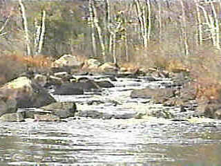 Immediately out of the pool at CR565, Lower Five-Six-Five begins. This is a fairly long, relatively 'blind', technical, boulder garden drop (II-III normally, III+ at good flows), as the river twists to the right. A good pool follows, with about a quarter mile paddle to the final drop.
|
 An island splits the river. At the risk of being tremendously corny, I would describe the two sides of this island as the 'Homme' side ('homicide') and the 'Sweet' side (pronounced quickly and indistinctly, so as to sound like 'suicide'). (OK, I said it was bad . . . if you are familiar with this run, email me with your name for each side of this split falls.)
The left side starts with an easy wave in the entrance, dropping to an eddy against the island. A short channel leads to a rock which funnels the flow to drop ~5' into a rather shallow pool below. The sloping approach (tight on the right rock/island shore) gives a boater enough momentum to minimize the hazard of relatively shallow bedrock in the landing zone. Angle well out from shore (the island), as the right side of this drop lands on rock. The outflow of the pool is choked by rocks which you will thread through. Minor rocky rapids follow, leading to a huge pool downstream. |
 The right side is much wider, carrying more of the flow. There are a number of possibilities for you to line up, most of which would end with you scrambling to avoid pitons or keeper hydraulics at the base. If you can find a line you really like, you're a better man ('Homme') than I. While this is certainly runnable (and has been run), the left channel (as previously described) is certainly the more 'straight-forward' route.
|