The dam which formerly existed on Dam Road has been removed. (Does that mean they will rename the road?). As a result, boaters may wish to check out the new suggested put-in. You will have a good warm-up on a couple of additional ledge drops, and a couple hundred yards of good moving class I-II water, where they have rechannelized the river where the dam was, before encountering the first larger ledge combination. Runnable either left (smoother, with a short boof) or right (double ledge/hole combination). Another brief bit of paddling through class II and increasing gradient leads to Powerhouse. Make certain to take out (river right for portage, river left to scout and run) in plenty of time, as there are fewer and fewer good eddies the closer you get the the drop.
The falls is very grungy center and right. The approach to the falls generally has you running river right (left is shallow rock ledges). Just before the falls, eddy river left. From this eddy, the falls has been run very tight left, angled right. Caution: the landing may have some shallow rock. Mandatory boof (or portage). |
 More class II bobbling brings you to a pooling in the river, a sign to get out (left) and scout The Slot (A.K.A. A**hole). Huge boulder/bedrock on each side funnel the river down a narrow chute into a hungry hole backed up another huge rock just down stream (sometimes known as Hemorrhoid Rock, since it can be such a pain in the a**). The sweet line is to start river right, and, with good momentum, hit the top of the slot angled to the left, to more or less boof / rock-grind off the left-side rock into the eddy below.
 |
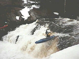 The next significant action is a pair of runnable waterfalls, Little Falls and Big Falls (scout left). The usual line on each of them is pretty well to river left, where you'll generally submerge briefly at the base, then easily paddle out of the boil. One of the falls has a sweet 'left-to-center' line, which gives you a great boof into the pool below. After these falls, the action is 'tamer,' as the river breaks into a series of short ledges and slides which can be run pretty much anywhere, and are great fun.
 |
 A clearing and house on the left, and the river rounding an elbow to the right signal the final drop above the Hwy.41 bridge. Barking Dog Rapids (whose namesake lives (lived?) in the aforementioned house) is a wonderful long series of ledges. While many groups run this down river right (where
it is a smoother, more gradual slide), the group I paddle with have always preferred the left, where it is a series of ledges and holes. Some groups take out after running this rapids, skipping the final three big drops leading down to the bay.
A clearing and house on the left, and the river rounding an elbow to the right signal the final drop above the Hwy.41 bridge. Barking Dog Rapids (whose namesake lives (lived?) in the aforementioned house) is a wonderful long series of ledges. While many groups run this down river right (where
it is a smoother, more gradual slide), the group I paddle with have always preferred the left, where it is a series of ledges and holes. Some groups take out after running this rapids, skipping the final three big drops leading down to the bay. |
Under the Hwy.41 bridge (and railroad bridge immediately downstream) a series of riverwide ledge/wave/holes lead into a big stairstep sliding falls, Middle Falls (scout left). This drop can be fairly intimidating to the uninitiated, but it has a couple of choice lines. Generally it is run mostly down the left. Beware of a final ledge downstream of the main part of this slide, which can form a fairly assertive hole tight to the left.
A brief respite leads you to the second big drop. The river bends around to the left and slides down a wonderful, fairly uniform long slide, Lower Falls. Usual route is right down the center, usually scraping most all the way, where the slide ends in a (normally) shallow punchable hole. A nice change of pace, though, is to stay well to the right, where the slide ends in an abrupt 4-5' ledge where you'll boof into a pool. |
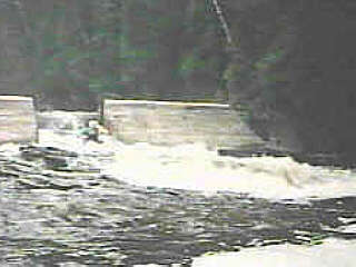 Shortly downstream the river pools up a bit at an old dam. At the center of the dam is a gap through which the entire flow is channeled. Run with a right-to-left angle to avoid shallow bedrock extending from
the right at the base of the dam. Before running, you may wish to check for people fishing at the base of the dam (and beyond, to the mouth of the river).
Shortly downstream the river pools up a bit at an old dam. At the center of the dam is a gap through which the entire flow is channeled. Run with a right-to-left angle to avoid shallow bedrock extending from
the right at the base of the dam. Before running, you may wish to check for people fishing at the base of the dam (and beyond, to the mouth of the river). |