![]()
![]()
| Return to the "Put-in" (Home page) | Format of descriptions | Disclaimers |
| RIVER: | Rock River (to Sturgeon River) |
| LOCATION: | Covington, Mi. (15 mi. SW from L'Anse) |
| AMENITIES: | Click for Michigan Amenities (food, lodging, etc.) |
| PUT-IN: | Bridge on gravel road just downstream of Worm Lake (often redundantly referred to as Vermilac Lake, I.E., "Worm Lake" Lake) |
| ALT.PUT-IN: | Hwy.28/141 bridge |
| TAKE-OUT: | Private property at confluence with Sturgeon (if gate is open, and permission is obtained). |
| ALT.TAKE-OUT: | Plains Road, after 3.0 miles of dead-flat paddling on the Sturgeon. |
| SHUTTLE: | Go west on Hwy.28 1.0 miles to Foy Road, right (N.)0.2 mi, W. 3 mi.
to Plains Road, right (N), 1.5 mi to Park on left
--or-- continue on Plains Road, bear right (to stay on Plains) 0.6 mi (2.0 mi total from Park), right (E) on unnamed road, 3 mi. (bear right at 3rd fork ~1.2 mi) and stay on main road to cabin at Sturgeon river. |
| DIST: | 5.0 miles |
| TIME: | 2.0 hours |
| CLASS: | II-III |
| CHARACTER: | Fairly continuous, moderately technical maneuvering, small (relatively narrow) intimate stream. |
| GAUGE: | Three marks painted on the Hwy.28/141 bridge indicate low (minimum), moderate (optimum), and high (never seen it, but likely to be a SCREEM!) levels. |
| SEASON: | Generally runnable only in early spring or after heavy rain. |
 As indicated above, this run is fairly continuous class II-III, with frequent additional hazards caused by log jams, beaver dams, and low bridges. At higher levels (above the middle gauge mark) a couple footbridges (one on "upper" and one or two on "lower") become significant tests of your limbo capability, and could require portaging.
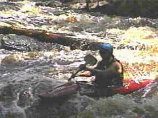
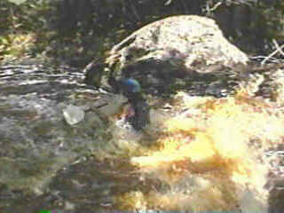
The only drop deserving special mention occurs in the middle of the run (both photos), where the river takes a turn to the left, drops through about 50 yards of class II-III drop, then takes a dogleg to the right past a few large boulders, and proceeds with some more enjoyable action. Excellent boat control may allow this to be run with cautious boat-scouting, but it is generally advisable to scout it first to be sure of your line and to be aware of any obstacles. This drop regularly has snags which need to be cleared or manipulated (to a semi-benign position) and sneaked. |
 Be extremely cautious running this river. Do not be misled by the II-III rating. It is small and subject to many snags. Eddies are small to non-existent at moderate to high levels. Boat control is at a premium due to the continuous nature of the run at those levels. Flips are likely to be punished, and swims could be brutal and long.
Do not assume that this is just like the Wolf or the Peshtigo (unless it is below the middle mark)! If you do have the necessary confidence and skills, and are fortunate enough to catch this "up," you will see why it becomes a favorite "less serious" fun-run for many people who boat this area. Note: Vidcaps (photos) from level 2" shy of middle mark (1999.05.29). |