![]()
![]()
| Return to the "Put-in" (Home page) | Format of descriptions | Disclaimers |
| RIVER: | Sturgeon River, Canyon |
| LOCATION: | 9 miles South of L'Anse, MI |
| AMENITIES: | Click for Michigan Amenities (food, lodging, etc.) |
| PUT-IN: | Hwy.41 |
| TAKE-OUT: | 1 mile downstream |
| SHUTTLE: | Carry back to your vehicle via paths and boardwalks. |
| DIST: | 1.0 miles |
| TIME: | Scouting (ahead of time) will take longer than the run (if you even decide to run it). |
| CLASS: | IV-V |
| CHARACTER: | Incredible, intense, gorgeous, awesome, intimidating. I HIGHLY recommend a visit to this stretch of river. MOST will be content to just view it, leaving their boat securely with their vehicle in the parking lot. Note: do not confuse this (as I regularly do) with the Sturgeon Gorge, which is 10 miles west (20+ miles downstream). |
| GAUGE: | U.S.G.S. at Sidnaw. Min:250, Opt:500, Max:800 (For most, this run will be a 'fantasy/nightmare' only.) |
| SEASON: | Spring/early summer. |
 From the Hwy.41 bridge you will find increasing action as the river heads to a left hand bend. A series of river-wide diagonals and wrapping waves is quickly encountered. These would be some of the sweetest surfing I've ever seen, if it weren't for the fact that just downstream the river jumps off a 12-15' ledge into the depths of canyon proper.
 |
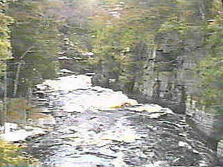 Downstream, the river is channeled deep within vertical walls, making escape all but impossible through most of the remaining way until the take-out. A series of waves and holes of varying intensities exist.
 |
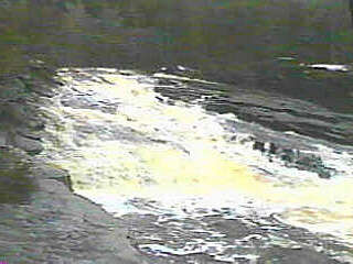
 In one of the most significant spots, the river is squeezed through a narrows, dumping into a very ugly aerated hole below.
 |
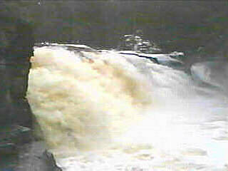
 As the canyon walls open up and the action diminishes, one is lead to the final drop. The flow is divided, as the river slides down Upper Falls.
 |