![]()
![]()
| Return to the "Put-in" (Home page) | Format of descriptions | Disclaimers |
| RIVER: | Yellow Dog River, Lower |
| LOCATION: | 20 miles NW of Marquette, MI |
| AMENITIES: | Click for Michigan Amenities (food, lodging, etc.) |
| PUT-IN: | Hwy.510 |
| TAKE-OUT: | Hwy.550 |
| SHUTTLE: | Proceed (NW) on Hwy.550 3.9 miles to Hwy.510. Turn left (SW) and proceed 6.6 miles to bridge over the river. |
| DIST: | 4.0 miles |
| TIME: | 2.5 hours |
| CLASS: | II-IV |
| CHARACTER: | Pool/drop; Seven major drops (of which most boaters at most levels will portage at least 2-3!), and a handful of smaller rapids, in about the first mile, then a long, flat but flowing, snag-prone paddle-out. (Always scout each of the main drops on this run as they all are likely to hold snags.) |
| GAUGE: | Visual. Below the bridge at the put-in (Hwy.510), in the water there is an I-beam with three bolts in it. Absolute bare minimum is all three bolts showing (probably not worth doing, but you can boat it). Good (usual run) is when water is at or over the top bolt (but some of the I-beam is still visible.) |
| SEASON: | Spring (April) |
| This is a relatively seldom run "gem", largely I suspect for three reasons:
1) there is no gauge, save for driving there and looking at the river. 2) it is a long way from more common, popular runs (Presque Isle, Black, and L'Anse area) 3) there are few alternate choices in the area (if it's not running, you'll probably head to L'Anse to boat) That said, it is among my favorites in the U.P. of Michigan. (Maybe it's also the brewpub in Marquette which we always visit afterwards which influences my opinion! And this one offers "carry-outs"! See Boaters Best Bets.)  After a short, mostly flat (and prone to snags) access paddle, the river turns sharply left and you will hear the rush of Hills Falls. We have looked at this bad boy (on both sides) for many years, and hypothesized lines on it. "If . . . If . . . If . . . and If only . . . ." Recommended portage (either side).
|
 Shortly downstream you will encounter a potentially sticky, potentially playable ledge, Jaws II (the sequel is seldom as good as the original). (If you've done the Nolichucky, you'll know what I mean.) Just downstream from that is another sloping ledge drop, which can generally be run pretty much anywhere, though it is likely to be scrapey down the center.
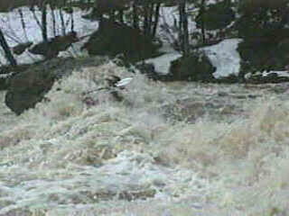
As you come around a left bend, you'll see a series of offset holes, and a narrowing in the distance. Get out (river left) to scout Eyeball. The series of short ledges, waves, and holes leads to a diagonally pitching ledge with a huge erratic boulder (the Eyeball) perched precariously, blocking the right side of the drop. A right-shore "hollow" exists behind (the "eye-socket"). From upstream, most of the flow is diverted to the right, toward the boulder (which develops a pretty fair pillow), before being redirected left into a mushy, funky hole, then over a ledge into another slightly more well formed hole and a good pool below. While not THAT big a drop, it has never failed to get my heart racing. |
 Trailing rapids quickly lead to a right hand bend and "Gullet" (scout left), where the river drops over an irregular sloping ledge. The right side stays higher, then drops off (forward and diagonally left) mostly onto shallow angular rock. River left (between the left shore-rock and the diagonally sloping river right bedrock) forms a deepening "V," funneling into a (not keepy) hole, some "funny water," and a final ledge/hole. Some play may be possible here, though the water temperature when this is runnable and desire to keep muscles "fresh" for the remainder of the run usually dissuades us from much dallying.
|
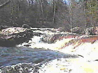
 The next drop, Dog Leg, is the longest combination on the run. The river swings to the right (scout left), over a short ledge to a brief pool, then a 4' sloping ledge into a hole. The strong outflow from there leads straight into a huge boulder (see photo) in the center of the channel. The right side (beside and below) is a jumble of rocks (pretty impassible). The left side has a shallow ledge extending from shore (parallel to the current leading to the rock) over which the flow tumbles, and is directed onto another rock to "trip over" as you finish Upper Dog Leg.
|
 A brief bit of slackwater leads to Lower Dog Leg. A rocky island splits off a narrow (unrunnable) channel to the right. The left channel is wide enough to allow a few good routes to run this double ledge combination.
|
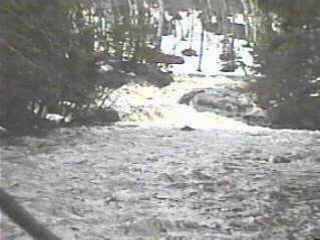
Another brief paddle brings you to a tight left bend and Bushy Creek Falls (scout left). A couple short ledges and a brief pool precede a narrow slot. The river is stuffed between the rocks and into a couple violent holes before racing through the pool below. While this squeeze has been run, we have yet to see it at a level we liked. |
 Shortly downstream, you will reach another sharp bend to the left, and hear the rush of
Junkyard (scout left). From the pool above, the river turns left as it slides through offset waves. It is then twisted right, through diagonal waves and holes, jumps off a 3' ledge, then twists left again, and spills across jagged, irregular rock before jumping off a final uneven ledge into the pool below. This always looks big and mean (as a junkyard dog, hence the name). I'm still waiting to have the right combination of boat, water level, and frame of mind to tackle this drop.
Shortly downstream, you will reach another sharp bend to the left, and hear the rush of
Junkyard (scout left). From the pool above, the river turns left as it slides through offset waves. It is then twisted right, through diagonal waves and holes, jumps off a 3' ledge, then twists left again, and spills across jagged, irregular rock before jumping off a final uneven ledge into the pool below. This always looks big and mean (as a junkyard dog, hence the name). I'm still waiting to have the right combination of boat, water level, and frame of mind to tackle this drop.
|
Not far downstream, the river again bends to the left and jumps over Wag (scout right, if so inclined). This short (~3') ledge may be boofed to the right, though be aware it may be a hard landing (piton). Center is ok, though there are some rocks to contend with as well, and far left is an easy slide through a wrapping wave into strong current along a wall of rock rising from the river. From here the current quickly diminishes, and the only action for the (roughly) 3 mile paddle-out is dodging shoals and strainers (and talk of how good the first beer at Vierling will be). Note: Vidcaps (photos) from run at "top bolt" level. |