![]()
![]()
| Return to the "Put-in" (Home page) | Format of descriptions | Disclaimers |
| RIVER: | Cedar Creek, Cedar Dells |
| LOCATION: | Cedarburg, WI. |
| AMENITIES: | Click for Cedarburg Area Amenities (food, lodging, etc.) |
| PUT-IN: | City Park, near Hwy.57 downtown |
| ALT.PUT-IN: | Parking lot between bank and Eye & Dental building (formerly Bridal Shop) (N.edge of Cedarburg on Hwy.57 at Columbia Road) |
| TAKE-OUT: | CTH.T |
| MAP: | Cedar Creek (Will open new window. Close it to return here.) |
| SHUTTLE: | CTH.T west 0.8 mi. into town to the city park,
-or- CTH.T west 0.4 mi. to Highland, right (N) to Hwy.57, right (N) to bank/bridal-shop parking (.2 mi) |
| DIST: | 2.2 mi. |
| TIME: | 1-2 hours |
| CLASS: | II-III |
| CHARACTER: | Shallow bedrock rapids, short ledge/waves, gorge/dells, portage(s). |
| GRADIENT: | 40fpm, though most of it is buried and unusable, backed up by a series of (generally unrunnable) dams. |
| GAUGE: | U.S.G.S. gauge: min=50, opt=350-650, high=1130
"Bankfull" level is around 975 cfs; "Flood stage" is around 1400 |
| SEASON: | Generally entertaining only in early spring or after heavy rain, though it can be run down to quite low levels.
(Best opportunities are March/April/May. Very rare outside those months to go above 300 cfs.) Note: Since the described run contains two significant stretches backed up by dams, this run does not 'open up' as early as others in this part of the state. If one can get access near (above or below) the Nail Factory Dam, it is possible to 'push' the season up a little bit on this run. |
| ANALYSIS: | Min.=0 cfs; 90%=7 cfs; 10%=170 cfs; Max.=3320 cfs; 10/90=23.9
> 300 cfs = 21 days/yr, 8/8yrs > 400 cfs = 10 days/yr, 7/8yrs > 500 cfs = 6 days/yr, 6/8yrs > 600 cfs = 3 days/yr, 4/8yrs > 750 cfs = 2 days/yr, 3/8yrs > 1,000 cfs = 1 day/yr, 2/8yrs |
 This section starts in a city park, where a sign gives some of the history of the river and the city. It mentions the historical name of the river was the "Mequonissippi," and tells that in its 32 mile length, it drops 350'. Elsewhere I've seen information which suggests that there is 100' of drop in 2.5 miles in town, 40fpm gradient, except most of it is backed up by a series of four dams. Between, and after the last of those dams, lies fun for local boaters.
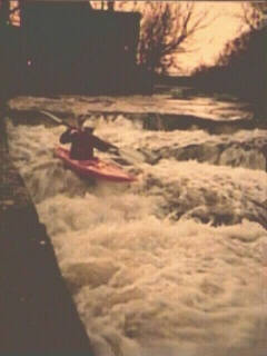
You will start here with City Park Ledges, about 4' of drop in about 15-20' of run. The left side has the steps more spread out, while the right side is more abrupt. The hole at the base of these ledges can be playable at the right water levels (if you don't mind the water quality, tight quarters, and generally shallow bottom). Some good moving water and small waves through a channelized section of creek in the park lead to a ten minute flatwater paddle on the backwater of the next dam. |
At the end of the pond, IMMEDIATELY at the downstream right edge of the Highland Drive bridge (a pretty, stonework structure), take out on the right for a tough portage around the Columbia Mills Dam. CAREFULLY climb up through a landscaped backyard. PLEASE be very careful of stonework -- leave things as you found them. Also, if possible, while setting shuttle it is a courtesy to at least attempt to contact the property owner to let them know what you will be doing and ask permission for the portage. (I have never had a problem, but it is always nice to ask first.) Carefully lower down the 12' wall about 30' below the dam where there is a little notch in the wall, near a tree in the river. (Note: The landing zone at the base of the dam is uniformly shallow, and the reversal becomes quite ugly, making running this dam extremely unlikely (and unwise).) |
 Just downstream of the Columbia Road Dam lies a set of easy sliding ledges, Bank on It (or Bank Waves). At higher flows, these build into nice surfable waves. At levels above 600cfs or so, there is also generally enough depth after the last wave to get some tail squirts. (This is an alternate put-in, avoiding 0.6 mile flatwater and the portage as previously described.)
|
 The runout from the above ledges puts you in the backwater of the Nail
Factory Dam. Enjoy the rocky outcroppings as you paddle the 0.2 mile 'pond', and hypothesize about the beauty (and rapids?) of the grotto which it inundates.
The runout from the above ledges puts you in the backwater of the Nail
Factory Dam. Enjoy the rocky outcroppings as you paddle the 0.2 mile 'pond', and hypothesize about the beauty (and rapids?) of the grotto which it inundates.
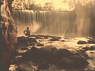
This 18' dam has been run years back, at lower flows. Be aware, however, the gorge wall below the dam angles in significantly, so you would not want to run the rightmost 1/4 - 1/3 of the dam. At moderate to high flows, the reversal looks nasty. Look before you 'leap.' For most boaters, another tough portage river right (walking the dam wall and sliding down another steep embankment between trees about 70' downstream) leads to the lower gorge. A short rocky rapids below the dam, and swirling waters in a steep-walled dells soon give way to more 'reasonable' banks. |
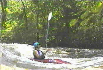
 Shallow shoals and easy surfing waves warm you up for Estate Bridge Rapids. This consists of a shallow slide into a constriction caused by a bridge pier, along side which forms a hole, playable even as low as 100cfs. At higher flows, the wave "migrates" upstream, and becomes a very fast ride. This upper wave can usually be regained (with skill and practice) at low to moderate flows, while a short portage back upstream will be in order at high flows if you don't come off the wave in control and immediately acquire the river-left eddy.
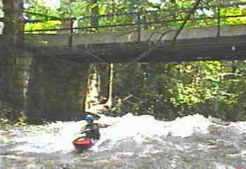
The downstream end of the bridge pier (river-right) can provide some vertical action, as well as a seam off the left wall which can provide great tail squirts. A series of standing waves (at moderate to high levels) is great for practicing ferries, peel-outs, eddy-turns, et cetera, and may also allow throwing a few wavewheels. Just as the waves die out you will encounter Railroad Rips, a couple of small (6") ledges just upstream of a high railroad trestle. At higher flows, these waves will be "catch on the fly" or forget it. Note: Vidcaps (photos) from run at 1130 cfs (1999.07.23). |
The creek swings to the right with some more shoals and waves. Tight to river left are a couple of small, potentially playable holes (especially for shorter boats) with small eddies alongside. Passing under a private bridge through shallow rocky rips, the creek comes to a large island, looking almost like a dead-end. The normal river channel turns sharply left, and is often subject to strainers and downed trees making passage hazardous. A SMALL (paddle width) channel exists to the right which cuts across the meander in the creek. (Note: as of summer of 2000, most of the snags in the main channel have been removed, though a couple leaning/over-hanging trees still present a significant hazard. As of summer of 2001, someone has done major clearing of the small channel, making it a 'preferred' route.) After the channels rejoin you'll have clear paddling past significant downed trees and past a drive-thru shoals. A left hand bend and an island with a foot bridge from the right shore signal the approach to CTH.T, your exit for the shortest shuttle and best action. A "Take Out" sign has been put up at this point. (Why this sign was put here is somewhat a mystery. I believe it may have appeared about the time that a short dam was removed downstream at Hamilton, and may have been placed to ensure boaters did not proceed downstream while that was in progress. I'm hard pressed to figure that there was really that much boater traffic utilizing this stretch of river to make placement of the sign really necessary.) |