![]()
![]()
| Return to the "Put-in" (Home page) | Format of descriptions | Disclaimers |
| RIVER: | Devil's River |
| LOCATION: | Manitowoc County, near Cooperstown, N. of Kellnersville.
From I43 exit at CTH.Z(W)/Hwy.147(E), east to river, or to CTH.R. then north to Maribel Caves County Park |
| AMENITIES: | Click for area amenities (food, lodging, etc.) |
| PUT-IN: | Pleasant Road |
| TAKE-OUT: | Hwy.147 (easy access, but on a somewhat busy highway). |
| ALT.TAKE-OUT: | Maribel Caves County Park, off CTH.R (Note: Cuts off about 1.5 miles of mostly flat-but-flowing water, but necessitates a significant hike up stairs to the parking area. I recommend you take a hike down to the river to see where you'll be getting out (and possibly mark it), as well as to prepare yourself for your carry back to your vehicle at the end of the trip!) |
| MAP: | Devil's River (Will open new window. Close it to return here.) |
| SHUTTLE: |
From recommended take-out on Hwy.147, go west 2.0 miles to Pleasant Road then north 1.7 miles to the river.
If utilizing Maribel Caves park, from the park road, proceed 0.5 mile north on CTH.R to Schley Road. Go west 1 mi to Pleasant Road, then north 0.5 mi to river. |
| SHUTTLE LENGTH: | 3.7 miles, 10 minutes |
| DIST: | 3.9 mi. (2.4 mi.) |
| TIME: | 1-2 hrs |
| CLASS: | II-III |
| CHARACTER: | Short 3x3' ledge dells section; shallow rocky rapids & ledges.
Note: water quality is generally horrendous (particularly in spring), due to the effluent from many cattle farms in the watershed. Don't even think about rolling or swimming in this cesspool (at boatable levels). (At times of lower flows, I'm told campers at the campgrounds here do enjoy swimming in the 'clean' water of the river.) |
| GRADIENT: | 35 FPM; 50' in last 0.5 mile (before confluence with W.Twin) |
| GAUGE: | If the rapids visible at CTH.R look runnable, go for it! Or, slightly more specific, at the put-in, on the upstream-left of the bridge, a rock sits against a slight 'V' in the cement abutment. If the whole rock is visible, the river is low. If just the top is visible, you have a 'moderate' level. If the rock is covered, all should be good. (I've run it at 18" over the rock. It was a blast!)
(Vidcaps (photos) below are from a run at minimal water level.) |
| SEASON: | Generally runnable only in early spring or after heavy rain. |
 Numerous downed trees are likely to be encountered downstream of Pleasant Road. (Depending on water levels, it may be possible to get over, under, or around these until they are removed.) After crossing under I43 and coming around a right-hand bend you'll see trailers and RV's in the Devil's River Campgrounds. At the end of this straight stretch the river takes a sharp left into some minor rapids from which you may hear the pounding of Devil's Falls.
|
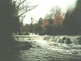
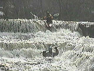 Scout from the left bank. This is a class III, shallow ledge combination (three ledges of about 1.5-2' each) followed by a couple of potentially sticky holes. After this you'll find about 1/8 mile of relatively continuous, rocky, shallow class II rapids and shorter ledges leading to CTH.R.
|
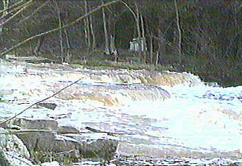 About 1/4 mile more similar rapids, past a nicely manicured backyard, (overlooking the 1-2' ledge shown at the right) leads to the confluence with the West Twin River. You may be inclined to hike a very short distance upstream on the West Twin to play the Devil's Meet Ledges. (With enough water, these are generally the best feature on the West Twin.)
After the confluence, the West Twin is pretty much just swift water and some good waves. You will float over a cement drive-thru and past a suspension bridge, some narrows and 'dead end' turns. As you approach the park, you may see a little cascading waterfall on the right, some more good waves, then flat flowing water to the take out. There is very little by which to identify this area when on the river. If you are using this take-out, it is strongly advised to hike down and mark or take good note of some landmarks before putting in, or you may have a longer carry to find the path to the parking lot. While there are decent wooden stairs, the carry up to the bluff top is probably the hardest part of this trip! Alternatively (for the recommended take-out), continue your float down the West Twin about a mile-and-a-half to the next bridge. About half is totally flat, then some minor riffles and gradient picks up for the remainder of the trip to Hwy. 147. P.S.-enjoy the park, trails, bluffs, and small caves; don't miss the ruins of the 'Maribel Caves Hotel' built in 1900. (For photos, see West Twin.) |