 From the Lime Kiln Park parking lot (just S. of Main, and just west
of the river), carry down to the river and upstream to just under the main
street bridge, where currents swirl off the upstream face of the bridge (just below the falls shown at left).
From the Lime Kiln Park parking lot (just S. of Main, and just west
of the river), carry down to the river and upstream to just under the main
street bridge, where currents swirl off the upstream face of the bridge (just below the falls shown at left).
|
 Shallow, rocky shoals quickly slope downward to a ledge with a small possibly playable
hole (if you have a short boat and don't mind being Up
Against a Wall). Unfortunately, there is generally very little 'pool' behind this, and the current pushes through, so you have to be quite aggressive to have any chance of even a single play here.
Shallow, rocky shoals quickly slope downward to a ledge with a small possibly playable
hole (if you have a short boat and don't mind being Up
Against a Wall). Unfortunately, there is generally very little 'pool' behind this, and the current pushes through, so you have to be quite aggressive to have any chance of even a single play here.
|
 The current slams against the river right wall,
which is slightly undercut, as you enter the Heart
of the Dells. A narrow gorge amid swirling waters leads under
a footbridge. More shallow waves and ledges follow, leading to a sharp
left bend just after the walls give way to a brief clearing on the right. A small surfable wave sometimes develops here.
The current slams against the river right wall,
which is slightly undercut, as you enter the Heart
of the Dells. A narrow gorge amid swirling waters leads under
a footbridge. More shallow waves and ledges follow, leading to a sharp
left bend just after the walls give way to a brief clearing on the right. A small surfable wave sometimes develops here.
|
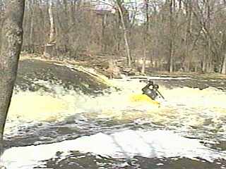 About 100' of swift flowing water over a uniform bedrock slab
leads to the 3' Kil'n Ledge (which is generally
a 'jump and bump' ride) best run to the left side. A pool with good side
eddies allows play in the frothy, shallow wave at the base of the falls.
Straight-on end surfing, side surfing, and 360's may be done to your hearts
content, with exit provided by digging deep for the downstream flowing
current, or by moving to river left where the stronger current may push
you out, but be ever mindful that the ledge is shallow, and an upstream
flip will mean a head banging (bottom-brace saves are likely to be the
norm here).
About 100' of swift flowing water over a uniform bedrock slab
leads to the 3' Kil'n Ledge (which is generally
a 'jump and bump' ride) best run to the left side. A pool with good side
eddies allows play in the frothy, shallow wave at the base of the falls.
Straight-on end surfing, side surfing, and 360's may be done to your hearts
content, with exit provided by digging deep for the downstream flowing
current, or by moving to river left where the stronger current may push
you out, but be ever mindful that the ledge is shallow, and an upstream
flip will mean a head banging (bottom-brace saves are likely to be the
norm here).
|
 Below this ledge/pool more shallow, rocky rapids lead to another
BADLY UNDERCUT wall on the left, as the river makes a right bend past a
churchyard/parking lot. (If it is, or has recently been, raining, the runoff
from the lot pours off a ledge forming a pleasant little 6' waterfall.)
Below this ledge/pool more shallow, rocky rapids lead to another
BADLY UNDERCUT wall on the left, as the river makes a right bend past a
churchyard/parking lot. (If it is, or has recently been, raining, the runoff
from the lot pours off a ledge forming a pleasant little 6' waterfall.)
Another ~1/4 mile of shallow, rocky rapids leads to the end of
the park, a short clearing, and the next road bridge, immediately after
which you should look to the right for convenient grounds upon which to
land.
The next 1/4-1/2 mile has some nice little waves and rapid moving water which may be interesting to do when the river is high enough, but it doubles the walk back to your car.
|
 Walk the shuttle back to your car in the parking lot on a paved path through the park. Alternately, dirt footpaths exist immediately alongside the river (either side), making a less conspicuous route back (though recent brush-cutting in the park makes the river-right riverside path much more visible than in the past). The river right path crosses a side stream, and is narrow and has a few fallen trees (which are easily surmounted). River left path (also prone to fallen trees) takes you through interesting relics of the historic quarrying operation which existed here.
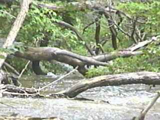
Note: Back in May, 2000, numerous downed trees completely blocked the river just around the bend below the "undercut wall" and past the sidestream. While these have long since disappeared, new deadfall and snags could occur at any time. Do not risk boating this river without walking the whole reach first. A deadfall or snag, a low-hanging branch or grapevine, any 'new' obstruction in almost any location on this narrow stream could be disastrous! Eddies are precious few and small, and even highly experienced boaters will be hard-pressed (at moderate or high water) to exit the river anywhere on this reach!
|