![]()
![]()
| Return to the "Put-in" (Home page) | Format of descriptions | Disclaimers |
| RIVER: | Menomonee River, Tosa section |
| LOCATION: | Wauwatosa, WI. |
| PUT-IN: | Butler Village Park (Waukesha County), just S. of Silver Spring @ 124th |
| ALT.PUT-IN: | Underwood Creek, behind former 'Sizzler' under Hwy.45 just south of North Ave. Note#2 Note#4 |
| ALT.PUT-IN: | Hoyt Park (just off Swan Blvd., south of North Ave.) Note#2 Note#4 |
| TAKE-OUT: | DNR landing at 43rd & Monarch (behind Miller Brewing, just off State Street) |
| SHUTTLE: | Return to State Street and proceed west 2 mi to 'downtown' Wauwatosa, past numerous stoplights. After the last light you'll be on Menomonee River Parkway. Proceed 1.4 mi to North Ave. For Alt. PUT-in, turn left (west) 0.8 mi to Hwy.100, then left (south) 0.3 mi to former Sizzler parking lot under Hwy.45. Otherwise (for 'full' run), continue north on parkway 2.1 miles to Hwy.100, turning right (north) 2.2 miles to Silver Spring where you'll turn left (west) 0.7 mi to Park Street, where a left (south) for two blocks brings you straight into Butler village park. |
| DIST: | 4.4 (10) miles |
| TIME: | 2 (4) hours |
| CLASS: | II-III (Well, calling any of this class III may be 'pushing' it a bit, but since the river 'canyons up' (man-made stone and/or cement walls) anyone out of their boat will have a tough time. Therefore I'm inclined to rate the overall section a bit higher than any individual rapids on the river, none of which really exceeds class II.) Be aware that this is an urban watershed. You must be fully aware of water levels and your skills before running this stretch of river. Water quality at times of high runoff after rainstorms is worse than the standards for untreated sewage. You do not even want to think about flipping or swimming in this 'city cesspool' of a river. Most of the lower portion of this run lies between vertical stone wall banks, making exit from the river all but impossible at elevated flows. Paddlers are strongly advised not to run with a single craft (just one solo or tandem canoe or kayak). In the event of an 'out of boat experience', you are likely not to reclaim your boat and any loose gear until it reaches the slackwater of the harbor (at least somewhere downstream of Miller Park). NOTICE: As of spring, 2005, there are multiple projects affecting various locations on this river which may affect or prohibit safe passage. Anyone planning to run the river is highly encouraged to scout as much of the run as possible before putting on. NOTE: removal of the old low bridge at Hawley Road has been completed, so this area is no longer a problem or concern as it had been earlier this year. The right bank in this area has had large quarried limestone rock-rubble laid in to line the banks. This makes access and egress quite possible here, but caution is urged, as footing will be treacherous and even fairly decent sized rocks are likely to slightly unstable. |
| CHARACTER: | Generally unobstructed smooth bedrock bottom forms a number of good river wide (30') waves. While most of the run will be relatively shallow sheeting water, there are a couple deeper 'squirt spots' and a few bridge-pier obstructions forming interesting currents and eddies. From about 76th to 43rd Street is fairly continuous II-II+ stuff! Water and sometimes air quality, however, are generally atrocious, as watershed is urban runoff, and the reach passes near foundries and other heavy industry when not in parklands. Note#6 |
| GRADIENT: | 15FPM |
| GAUGE: | U.S.G.S. gauge: min=250, opt=500, high=1000
Note: at levels above 1200cfs, the golf course bridge just downstream of Underwood Creek will have NO clearance! BEWARE!! It is advised to change put-in to Hart Park or some other point downstream at high water levels. Most features will tend to wash-out at high water levels (above 1200 cfs), resulting in a run which is pretty much a 'flush', with fast swirling waters and large catch-on-the-fly waves. ("Flush" may be appropriate in other ways as well, since heavy rains often result in raw sewage being dumped into various sections of Milwaukee's rivers.) Note#5 Note#6 |
| SEASON: | Generally runnable only in early spring or after heavy rain.
Note: the "10/90 Ratio" of 16.6 doesn't come close to telling how flashy this reach is. Since the majority of the watershed for this reach is freeways, parking lots, etc., even ¼" to ½" rain is likely to spike water levels up to 500-1000 cfs (or much more!) for literally just a couple of hours! Thus, the 'mean daily flow' (as reflected in the 'analysis' below) will be far less than the instantaneous flow of those few hours. |
| ANALYSIS: | Min.=3 cfs; 90%=14 cfs; 10%=232 cfs; Max.=7,520 cfs; 10/90=16.6
> 250 cfs = 36 days/yr, 23/23yrs > 500 cfs = 9 days/yr, 23/23yrs > 1,000 cfs = 2 days/yr, 18/23yrs > 2,000 cfs = 0 days/yr, 9/23yrs |
| From the Butler Park putin, you'll encounter various riffles and rips for about 1 mile until Hwy.45/100, then flat water for 1.5 miles until Capitol Drive. Just south of there you'll encounter a very low bridge for golf carts at Currie Park, followed by a 'drive thru shoals', and another low footbridge and rips. After ½ mile of flats you'll come to a river wide wave. Another ½ mi brings you to Burleigh Road and a minor drop. A mile of pretty flat water and minor rips brings you to North Avenue and, shortly after, the confluence with Underwood Creek, which was an alternate put-in. |


|
|
There is a project proposed (or underway) to remove the concrete from this channel (as well as making a number of other changes for holding ponds, etc. in the watershed). Thus, we cannot recommend access via this creek (at least until that project is completed).
Underwood Creek is a ½ mile of cement ditch (actually longer, but there is no good access quite a ways further up) with four "drop structures" (pour-over cement ledge/falls); the first is about 5.5' (recommended NOT run, since you will most likely drop hard into the cement bottom), the second and third being 3.5' and 1.5', and closer together (again, you may 'bottom out', but the shorter drops should not cause damage), and finally a 3' drop about ¼ mile later. A short stretch of natural channel leads to the confluence with the Menomonee River. To reiterate, however, it is illegal and hazardous to your health to boat this 'cement ditch'. See Note#6 Just downstream of this confluence is Decapitation Bridge, a golf cart bridge which is too low to pass under if the river is above 1200 cfs. About ¼ mile downstream is Swan Blvd. and Hoyt Park (alternate, but illegal, access). There are (usually) some easy class I-II rollers under the right side of the bridge. The next ¼ mile brings you to Stair Step Ledge, followed ¼ mile later by the Hoyt Park footbridge, where there are some waves and a little ledge river-left by a sewer standpipe. Just downstream, the river takes a sharp left bend as it encounters The Wall, a class II set of waves, followed by The Ledge, another class II river-wide playable wave/hole. Again the river takes a bend as it encounters the railroad and forms some more rips. |
 As you pass under the road, pedestrian walkway, and railroad bridge in 'Tosa, you begin a stretch of 2 miles of good, moving class II-II+(III?) water.
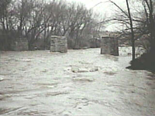
One place of note on this section are the piers of a defunct bridge in Jacobus Park. Caution: trees and snags are extremely likely to hang up on these piers, and are likely to be different each time you do the run (after high water and floods). Always approach this area with caution, or scout before your run. The upstream faces of both piers are undercut. Stay clear of the piers! Strong eddy lines form below to practice your ferrying and peelouts. A decent surf wave forms at most boatable water levels. This could make a decent park-and-play spot (particularly for winter thaw and early-season) except there is no legal access without written permission. Note#2 Downstream, the riverbed becomes almost uniformly smooth bedrock, and numerous slides (short sections of slightly increased pitch) create a series of sweet surfing waves. Depending upon water level (and your skill and interest) some may be regainable, but many will be catch-on-the-fly one-shot play. |
 Near Hawley Road, a couple large slabs of rock in the center of the river form the only significant pourovers and possible need for maneuvering. A sweet wave forms at higher water levels. In honor of the Wood Veterans Administration Center (about 1 mile south, near Miller Park) and in honor of the road above (rather tongue-in-cheek, doing a word-play on features on rivers elsewhere) I call this Hawley-Wood Hole.
Downstream from there, you'll encounter a few more good glassy waves (at higher levels) for good catch-on-the-fly surfs before you pass under Hwy.41 HIGH overhead. Rounding a bend to the left you'll find a railroad bridge with an easy boulderbed rapids. Caution: trees and snags are likely to hang up on these bridge piers. The river takes a sharp right and enters a walled-in section leading to the take-out. |
 As a result of a project completed in spring 2000, an improved landing exists at 43rd and Monarch. A 'drop-structure' and cement channelization was removed and LARGE rock rubble has been used to line the streambed. A breach in the stone wall has been created. At levels above 1000cfs, all the rock rubble will be covered by water. At all levels be very careful here, as the large rock would be very dangerous for anyone out of their boat. Foot entrapment is a possibility. Some rocks may shift and settle. Tread carefully to avoid slips and falls, which would be painful.
At most boatable levels, a wave (or wave-train) forms right at this take-out. Enders and squirt moves are possible in the strong currents (though not recommended, due to water quality and the liklihood of ingesting some of it when you splash or flip). |
Just downstream, the river is a cement ditch, and careens wildly into a railroad abutment (see photos below). There will be virtually no eddies and no egress from the river for another mile downstream, where significantly more natural (though still heavily human engineered) riverbed and banks resume in the Miller Park (former County Stadium) parking lot. The recommended take-out is also approximately the location of some of the pipes through which MMSD can dump untreated Combined Sewer Overflows into the river (another good reason for not proceding further downstream, as CSO's are highly likely any time this river cranks up to entertaining levels). 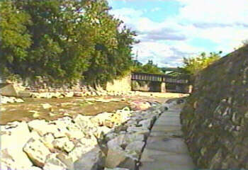

|