![]()
![]()
| Return to the "Put-in" (Home page) | Format of descriptions | Disclaimers |
| RIVER: | Milwaukee River, Falls Road / Grafton Dells section |
| LOCATION: | Grafton, WI. |
| AMENITIES: | Click for Grafton Area Amenities (food, lodging, etc.) |
| PUT-IN: | Bridge Street and 14th Ave. (1 block S. of Hwy.57 bridge) |
| ALT.PUT-IN: | Falls Road Bridge (for just park-and-play) |
| ALT.PUT-IN: | Lime Kiln Park (for just lower "Dells" swiftwater/canoe run with no portage, or for park-and-play) |
| TAKE-OUT: | CTH.T |
| ALT.TAKE-OUT: | Lime Kiln Park (for short shuttle, upper play run) |
| SHUTTLE: | CTH.T (Lakefield Road) east ½ mile to Manchester Road, left (north) ½ mi. where road takes a sharp left (west), ½ mile to 17th Ave, right (north) ½ mi. to Falls Road.
For Falls Road access, turn left (west) 0.35 mi. to the river. For Lime Kiln Park access, cross the river and turn left (S), 0.2 mi. to Green Bay Road, left (S) 0.2 mi. to the park entrance. Proceed straight back and park either at the first cul-de-sac (at the dam) or continue to the lower boat ramp. Otherwise (rather than either of the above) proceed another 0.6 mile to Bridge Street, left (W) a block, right on 16th Ave. 150', then left (W) again on Bridge Street to cross river to 14th Ave. -or- (alternate route) From the take-out, take CTH.T west 1 mi to Green Bay Road, right (N) 1.1 mi., bearing right where the road nears the railroad tracks (do not cross over tracks to connect to Hwy.57 between Grafton and Cedarburg). Proceed 0.2 mi. to Lime Kiln Park entrance, or continue 0.4 mi. to Falls Road, or continue (as Green Bay Road becomes 12th Ave), another 0.6 mile to Bridge Street, then right (E) 0.1 mile (2 blocks) to 14th Ave. |
| DIST: | 20 yards (Park 'n Play) or up to 3 mile run |
| TIME: | 1 hour run, or as long as it amuses you to play |
| CLASS: | I-II (up to class III for play spots in moderate-to-high water) |
| CHARACTER: | Short ledges, riffle/rapids, dams, dells. A fun park-and-play or short play run, or a scenic swiftwater float trip. |
| GAUGE: | U.S.G.S. gauge: min=200, opt=800-1200, high=2000
If the flat rock at the bottom of the 'chute' on river left at Falls Road has water flowing over it (or nearly so), it's a pretty good level. |
| SEASON: | Can provide some play most of the year. Best April-May. |
| ANALYSIS: | Min.=42 cfs; 90%=120 cfs; 10%=1000 cfs; Max.=4870 cfs; 10/90=8.3
> 1,000 cfs = 36 days/yr, 17/17yrs > 2,000 cfs = 9 days/yr, 12/17yrs > 3,000 cfs = 2 days/yr, 6/17yrs > 4,000 cfs = 0 days/yr, 3/17yrs |
| Generally hassle-free put in is possible from a powerline easement at the dead-end of 14th Ave., where street parking should be available. It may be possible/desired to put in further up toward Bridge Street to take advantage of some early waves and rips, though you may be met with resistance and/or require permission from owner/operators in the converted wharehouse/factory office/shops between the street and the river. Numerous small shoals in the next ¼ to ½ mile create some minor entertainment as one floats past rocky outcroppings. |

|
| As of January, 2001, the "chair factory dam" (old photo, above left) above Falls Road has been removed. The dam, an 'outer' wall of the old factory (which had supported a private deck) and a 'half-wall' which was in the river just slightly downstream were all removed. Clean rock rubble was trucked in to pile against the inner wall to shore it up. (Visible as the bright white uniformly sloping river-bank background-left in photo above right.) |


|
| As you pass the former dam-site and approach Falls Road, there is a river-wide ledge. On river left, water accelerates down a sloping tongue (background, above left) leading into a small hole backed up by a large, flat table of rock just downstream. Play in this hole can be difficult and grungy due to shallow splines of rock parallel to the flow in the pool -- flips are likely to be brutal. At low-to-moderate flows, all water (and boats) will be immediately diverted toward center river by the table of rock, while at higher flows (>800cfs) you may float straight ahead over it, most likely into a small reversal it creates (foreground, above right). |


|
|
Most of the center of the river tends to be a shallow and grungy scrape across slightly domed bedrock. At river right, a couple of upper glassy waves precede the main ledge (above left). All waves and holes here will be catch-on-the-fly, as the river right rock rubble shore has generally eliminated any eddies. Water sheets quickly across a massive table of rock between the first ledge and another short (at high water, coverered and 'invisible') ledge into a deep transverse channel in the bedrock. Another large table of rock downstream diverts the center-flow hard to the left (at low water) or forms a sweet wave/hole at higher flows (centerframe above right).
River right leads to a small but playable ledge/wave, backed by large submerged rocks (nearground above right). Caution: there is a short rebar stub in the bedrock just upstream of the wave. It should not cause any problems for playing the wave, but could snag someone out of their boat or upside-down coming down from the upper ledges. |
Many interesting divergent currents wrap around all the aforementioned bedrock, giving great opportunities for practice reading the water. Beginning boaters will find the area fine for practicing basic boating maneuvers (ferrying, peel-outs, simple forward surfs, etc.) while others may challenge themselves with attainments, more difficult surfs, and vertical moves off one pourover part of the ledge. At most levels boaters should be able to 'attain' from the pool below the Falls Road bridge back up to various places for play at the base of the lower ledge. Be careful. There is some rebar and much rock rubble submerged in places (difficult to describe or be certain of) waiting to grab your boat or you if you should be unfortunate enough to flip or swim. Do not try to walk or stand in any part of the river here (unless you are sure of the bottom), as currents tend to be strong at almost any boatable flows. Note: If doing Falls Road as a park-and-play, I generally recommend parking on Falls Road (East of the river and the "No Parking here to corner" sign) and carrying upriver on paths through the woods. This saves having to climb over the rock-rubble river-right shoreline (which may be somewhat hazardous, as the rock may shift and settle as you walk upon it). It also eliminates 'trespassing' overtly on the private property on river right (though the homeowner there has thus far seemed fairly friendly). While the woods on river left apparently is for sale (as three lots, I believe), it is a less intrusive access. Put in is possible by carefully carrying down one of a couple of 'chutes' to the river. |
 For those proceeding downstream (I.E., not just doing the Falls Road Ledges as a park-and-play), a few minutes paddling brings you to a classic KILLER, LOW HEAD DAM which is VERY dangerous at virtually all water levels! At high flows (E.G., around 1900 cfs) at extreme river left, a potentially runnable overflow channel exists around a rock/island.
(Scout first for wood!)
Also at high flows, a sloping cement 'apron' may be run high and tight on river right, dropping you downstream of the boil. (Scout first!)
A tight left grungy approach and dropover/boof just beyond the edge of the boil is possible as well. (Scout first!) Do not mess with any part of the dam proper unless the river is very low (E.G., around 200-400 cfs) and you are prepared to paddle hard to blast over the boil line! (Scout first!) Any errors in judgement may be fatal! Do NOT attempt any run unless you have complete awareness and confidence in your skills, as well as setting adequate safety (boaters/ropes). Recommended portage across the rock/island on river left (be aware of poison ivy) or well upstream of dam (and fence) on river right.
For those proceeding downstream (I.E., not just doing the Falls Road Ledges as a park-and-play), a few minutes paddling brings you to a classic KILLER, LOW HEAD DAM which is VERY dangerous at virtually all water levels! At high flows (E.G., around 1900 cfs) at extreme river left, a potentially runnable overflow channel exists around a rock/island.
(Scout first for wood!)
Also at high flows, a sloping cement 'apron' may be run high and tight on river right, dropping you downstream of the boil. (Scout first!)
A tight left grungy approach and dropover/boof just beyond the edge of the boil is possible as well. (Scout first!) Do not mess with any part of the dam proper unless the river is very low (E.G., around 200-400 cfs) and you are prepared to paddle hard to blast over the boil line! (Scout first!) Any errors in judgement may be fatal! Do NOT attempt any run unless you have complete awareness and confidence in your skills, as well as setting adequate safety (boaters/ropes). Recommended portage across the rock/island on river left (be aware of poison ivy) or well upstream of dam (and fence) on river right.Note: As of winter 2008/2009, the Village Board of Grafton has approved removal of this dam, and is currently seeking grants and funding for that process. Removal is likely in 2010. |

|
|
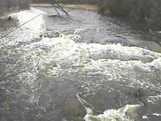
Beyond this dam lies an island, either channel around which has often been blocked (or partially blocked) by downed trees (right channel shown above left). Proceed with caution. The left side proceeds straight ahead from the dam, then takes a sharp right bend at the end of the island, as it encounters a rocky bluff which is slightly undercut. The right channel heads sharply right from the dam, then quickly bends left around the island. In high water, some nice standing waves form here, preceding a small ledge/wave/hole (shown above right). At levels around 1000cfs (+/- a couple hundred) this provides good surf and spin opportunities. Flips may be brutal, as it is backed up by a shallow, rocky stretch which deepens again as the flow other channel rejoins. The converging currents here may be good for some squirting practice. Again, boaters may wish to just use this as a park-and-play, either on its own, or in conjunction with Falls Road (parking at either site, portaging the dam, and paddling each way on the minimal current between the dam and Falls Road).
As the river turns west, there are class I-II rips for about ¼ mi. (past the lower boat landing in Lime Kiln Park) leading to the Grafton Dells, a scenic stretch along which there is a private picnic grounds. Another island divides the current, and both sides are runnable, though you may need to be on the lookout for strainers. It is not uncommon for the paddler to see deer crossing the river here or to chase up great blue herons along the following stretches. Good moving water continues to the bridge at Hwy.T, the recommended take out. |


|
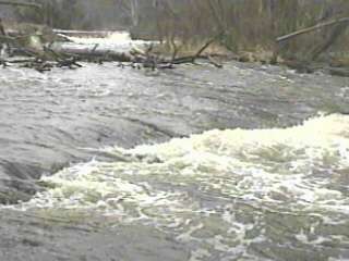
| Beyond Hwy.T the river becomes far less interesting, as the water slows considerably the rest of the way to Thiensville where it is backed up by a short (~3-4') killer dam (above left). The boil below often holds logs and other debris for DAYS when the river is high. It has also held unwary (read 'ignorant') 'boaters' (usually young kids/teens with a plastic raft) who have their last bit of 'fun' running the dam. On river left there is a ramp-like chute which generally creates little more than a disorganized, frothy wave at its base (background in photos above). The temptation and consequences of running this dam HAS COST LIVES every few years. This area is posted against boating within 200' of the dam. (And, the municipal building (police/fire) is right at the entrance to the park (in sight of the parking lot at the dam). Likely just as well since the play potential is generally quite limited, and the enticement/danger potential is far too great. |