![]()
![]()
| Return to the "Put-in" (Home page) | Format of descriptions | Disclaimers |
| RIVER: | Milwaukee River |
| LOCATION: | Milwaukee, WI. |
| AMENITIES: | Click for Milwaukee Area Amenities (food, pubs, etc.) (Will open new window. Close it to return here.) |
| FORMER PUT-IN: | One used to be able to access the river from W.RiverWoods Parkway (off of N.Port Washington Ave., just south of the river near Hampton and I43). An unofficial access road here was used by fishermen for years. However, a new holding company has the property up for sale, and has stripped much of the vegetation from the property (virtually down to the shore!), and has gated off the road, and posted "No Trespassing" signs. |
| PUT IN: | From Estabrook Parkway, just South of Hampton Ave, head down a one-lane road descending under bike-path bridge. This puts you right at the dam in Estabrook Park. This is the most convenient public access, and has now been officially designated as an official launch/landing site. (It is therefore legal to put-in here.) Note: this access road is not plowed in winter, and is in fact blocked off by a snow fence. Alternative access must be used at such times. |
| ALT.ACCESS (1): | Hilton Inn, 4700 N.Pt.Washington Road, back of parking lot (Obviously private property, which should be used only with permission secured from the business establishment. With such permission, the Milwaukee Ordinance regarding access to rivers through county parkland is properly circumvented.)
|
| ALT.ACCESS (2): | Estabrook Parkway, south end of north-most parking lot (a bit of a carry from the parking lot, past a park building/restrooms, and down stonework steps). This puts you at the same spot as the listed main put-in (off N.Pt.Washington and RiverWoods Parkway), but on river-left rather than river-right. Likely illegal, per Note#2 |
| ALT.ACCESS (3): | From Capitol Drive at the river (Humbolt Ave.) head north and proceed to end of road where a U-Park parking lot ("Capitol/Humbolt UPark") exists on the riverbanks. Park as close to the front as possible, carry back out, around the fenced-in detention pond, and down to a sweet double-ledge (minor bedrock-intrusion) wave.
(While the parking lot is posted as being for UWM permits only, I have seen little or no signs of strong enforcement. Specifically, fishermen make significant use of the lot to access this stretch of the river. This statement is not intended to endorse this practice, nor to exonerate anyone who chooses to use this access from possible tickets, towing or other actions which may be imposed. Use at your own risk.) |
| ALT.ACCESS (4): | From Humbolt Ave., two blocks north of Locust Street, head east on Chambers and park as far down the street as possible. (Do not go through the gate and into the Pumping Station grounds.) Carry down the dead-end stub, around or over a chain across the street, and straight ahead to the river. |
| PUT-IN/TAKE-OUT: | Riverboat Road (off Humbolt Blvd, below North Ave. bridge)
(At certain water levels, this is actually the #1 recommended put-in, to just park-and-play the best action the river has to offer in Milwaukee.) There is a paved parking area adjacent (behind Melanec's Wheelhouse), which generally seems to be fair game for river access parking. (Plenty of people are using it with no known problems.) Under no circumstances should you drive down to the river. While you will no doubt see other people doing so, you are driving on a BIKE PATH, and onto what is technically private property. While police may drive down there to patrol the area, private citizens should not! |
| ALT.TAKE-OUT: | Any of the options cited above or (if interested) paddle downstream (on completely flat-water) through downtown Milwaukee and (potentially) all the way to the harbor bridge and Lake Michigan. There are various public and a few private docks at business establishments where access is allowed. I recommend picking up a map of the Milwaukee Urban Water Trail, which is available from a number of sources around town, and is online from Friends of Milwaukee's Rivers. |
| SHUTTLE: | Proceed southwest on Riverboat Lane 0.1 miles. Turn left onto ramp to Humbolt Avenue. Turn right (north) onto Humbolt, going 2.4 miles. Turn right (east) on Capitol Drive, about 0.1 mile, crossing the river. Turn left onto Estabrook Parkway. Proceed past all visible parking lots to a narrow drive on your left, just before reaching Hampton Avenue (stop light). Take the narrow one-lane drive down to a parking lot at the dam.
For any of the many possible "alternate" runs, I will leave it to you to work out the shuttle with city maps and/or your knowledge of the city. |
| DIST: | 3.5 miles (from main (first) listed put-in to take-out at North Avenue Dam site).
Otherwise, 200 yards (or less) at each cited location for park-and-play boating. |
| TIME: | 1.5-3+ hours (depending on levels and how much you park-and-play) |
| CLASS: | I-II+ |
| CHARACTER: | River-wide waves and short ledges.
While the water quality of this river (year-round) may be regarded by many as 'iffy', when heavy rains occur and septic sewers are overloaded, various communities upstream can dump untreated sewage into the river (to keep from having it back up into people's basements). Specifically, at 32nd and Hampton, a pump was installed which is capable of spewing 167 million gallons per day (of untreated combined raw sewage and rain water) into Lincoln Creek. This is just 3 miles upstream of the Estabrook Park Dam (more-or-less the put-in for the full reach of this river). If my math is correct, that could mean up to 250cfs of raw sewage! Your MMSD tax dollars at work! While this shouldn't affect the river too many days of the year, it is something to keep in mind when the big rains come. See Note#6. |
| GRADIENT: | 10 FPM At the North Avenue site, the river drops about 5' in 200-300 yards of river. |
| GAUGE: | U.S.G.S. gauge: min=200, opt=800, high=1200
"Bankfull" level is about 5100 cfs; "Flood stage" is about 7400 Swiftwater and very minor play begins somewhere around 200cfs. Waves become well-formed for intermediate play around 400-600cfs. Waves will continue to build up to somewhere over 1000cfs, but increasingly things will become an eddy-less flush at higher levels. |
| SEASON: | Can provide at least mild opportunity nearly any time of year (other than coldest of winters and dry mid-to-late summer).
Looking at the past thirty years of USGS historical data, analysis reveals the following percentages of time for which the flow exceeds 200cfs (the suggested minimum for park-and-play at North Avenue). (No attempt has been made to differentiate (cull out) flows which exceed the recommended maximum flow for good play on the reach.) Jan - 74%, Feb - 80%, Mar - 96%, Apr - 100%, May - 93%, Jun - 79%, Jul - 60%, Aug - 57%, Sep - 57%, Oct - 68%, Nov - 84%, Dec - 80% Or, eliminating the above recommended maximum readings (over 1200cfs, even though some boaters may enjoy some of these levels), the following become the percentages of the time this reach has historically been between the recommended flows: Jan - 72%, Feb - 73%, Mar - 66%, Apr - 67%, May - 83%, Jun - 68%, Jul - 58%, Aug - 56%, Sep - 53%, Oct - 64%, Nov - 79%, Dec - 77% |
|
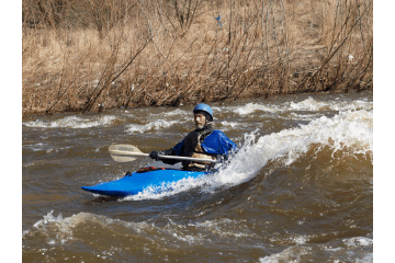
When local boaters refer to the "Milwaukee Wave," it is likely they are not talking about the local indoor soccer team. Removal of the North Avenue dam and subsequent rechanneling (sediment containment of the riverbed, using concrete paver blocks) creates an opportunity for some downtown boating. At low flows, boaters will concentrate on just a park-and-play at Chambers Street or at the North Avenue site, but the full run described herein has merit at levels above 400-500 cfs.
The recommended run starts downstream of the Estabrook Park Dam and "falls" at the north end of Estabrook Park (just south of Hampton Avenue). During the winter and early spring, all the control gates (on river-left) are wide open, and there is absolutely no interest here, as the river flows smoothly through. Once the gates are closed in spring, typically one or two will be used for controlling pond level. This creates possible squirt water, as strong currents rip through strong returning eddies on river-left below the dam. The "falls" (river-right of dam) generally accumulates all manner of trees and debris on the brink, effectively blocking this area almost completely from being run. Recently (2003/2004), most of this has been removed, so a potential window of opportunity exists for those who may choose to attempt to run this. Most of the anding zone is quite shallow. Water (at most boatable levels for the reach) generally sheets very shallow across the lip of the dam, which will stall a boat into an almost certain vertical descent and an embarrassing (or damaging) piton. Running the dam is therefore not generally advised unless you have managed to scope-out a good route in times of low water. |


|
|
The first feature of the usual run is the Estabrook Park Ledge. There is a slight shallow tongue far to river-left, which is met with fairly shallow rock (along with the occasional shopping cart or other debris) in the pool below. The rest of the river is generally an abrupt pour-over. Just right-of-center, above the main ledge, a short bedrock intrusion creates a diagonal wave/hole which may provide some guts play for intermediate-to-advanced paddlers who are able and inclined to play it. Play potential here is generally rather limited, mostly amounting to what I'd call park-and-flail boating. At lower flows, there is not sufficient depth anywhere here for any vertical action. At medium flows, the main ledge develops into a very keepy looking river-wide hole. At higher flows (somwhere above 2000 cfs) the ledge disappears, and all that remains is a couple of river-wide waves which could allow surf-on-the-fly (and carry-up) play. This area is often tends to be populated by people fishing near either shore, making it best to run down the middle, and proceed downstream, where better play awaits.
About a half-mile downstream, a shallow rocky section (a drag at under 500 cfs, fun splishy-splash above that) leads past the "Capitol/Humbolt UPark" to a sweet little double ledge (river-right). At levels around 500-1000cfs, U-Park and Play has two wide, shallow waves, which allow surfs and flatspins. At some levels, good boaters should be able to attain from the lower wave back up to the upper wave. (This area could be accessed from Alt.Access (4) for park-and-play.) The river is quite shallow here, and the wave/holes are backed up immediately by shallow rock, so flipping here is not going to be pretty. These will wash out somewhere above 1000 cfs. More flatwater and additional areas of riffles and rips lead to another small feature off the end of Chambers Street (just upstream of Locust Avenue; see access#5 listed above). The remnants of an old timber dam or low-water bridge block the left 2/3 of the river. At river-right, a small, smooth, glassy wave (good for surfs and flat-spins at certain levels) is followed by a deep pool. Good current, well-defined eddy lines, and good depth here (even down to water levels as low as 130 cfs!) make Timber Dam (a.k.a. Pumping Station) an excellent spot to practice basics (peel-outs and ferries) as well as slightly more advanced maneuvers (stern squirts, bow stalls, eddy-wheels). This feature tends to wash out at higher levels (somewhere between 800-1000 cfs). In general, it is best to avoid the center and left part of the timber dam. At most levels, little or no features occur there, and (even if/when something is present) there are very irregular timbers, planks, and spikes (both in the dam works and submerged in the pool immediately downstream of this side of the dam) which might snag a flipped boater. Not far downstream, under the Locust Street Bridge, there are some riffles and shoals. At low water levels (130-250 cfs) there may be some minor play possible here, but boaters should be aware of much cement rubble in the river (no doubt from the last time the bridge overhead was rebuilt). At any higher water level, this just smoothes out to a swiftwater rips or minor wavetrain, but generally contains nothing which creates any playable features. There is a minor secondary channel to the left of the bridge support which could (at some levels) contain something of interest, but I have not taken the time to explore it at enough levels to be certain. The next stretch of river is flat but flowing until you reach North Avenue. |

|
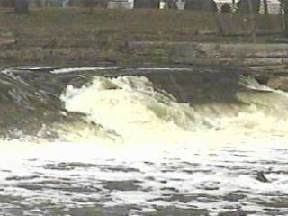
Directly under the upstream edge of the North Avenue bridge, the sloping cement/rip-rap-remediation bottom creates a shallow, smooth green-wave river-right, and small, pocket-wave/hole river-left (photo above left), which I call Shadow (since it is almost always in the shadow of the bridge). The water is typically only a few inches deep above and in the wave/hole, as it is sheeting across the paver bottom, so play is generally limited to surfs, flat-spins, and blasting. Clean 360's can be done with ease, but it is great to work against the grain as well.
Downstream river-right or center-river (depending on water level), just out from under the bridge, lies a small wave, Homeless (named for the street-people who take refuge high up under the ends of the bridge). At many levels, most boaters will either not see or not catch this wave. Since it has no eddy (no home), when it is present, it is strictly catch-on-the-fly. |
|
Not far downstream (at levels around 600cfs, +/-), you'll find Typewriter, a sweet diagonal wave. While it looks like it might just typewriter you off to river-left, I found when it is well formed it surfs pretty well, and allows carving back and forth across the whole wave, as well as some great spins.
(This is named to honor Christopher Latham Sholes, who lived in Milwaukee, and is generally creditted as the inventor of the first commercially viable typewriter.) |
|


|
|
Proceeding downstream, a series of waves develops left-of-center at good flows. The first couple can provide good surfs, and have enough power and depth (barely, at 850cfs, anyway) for a bit of vertical action (above left). The last of these, Showboat, is a deeper, mushier play hole in the middle of the river. At levels as low as 150-200 cfs this can provide some tame play (sufs and flatspins). At higher levels, it can be pretty dynamic, even allowing some vertical action (above right). While it is shallow up front, there is generally good depth in the pile and the pool behind. Strong currents rip down the center of the pool, allowing great bow-stalls and stern-squirts. Note: Just downstream-right of the Showboat hole, there is an uplift to the rip-rap bottom and a pile of shallow rock. While it lies pretty much in the eddy (at 200-600cfs anyway), and is therefore relatively out of the way, it is best to be aware of it.
Note: Highwater events and annual ice-out regularly re-arrange both the rock-rubble which lines the banks and wingdams which help create some eddies and features. As a result, even at a given water level, some features are highly prone to be different from one year to another. Not far below Showboat, the entire width of the channel is littered with rock rubble, creating a frothy, irregular choppy set of waves, with a swiftwater wave-train leading to the remnants of the North Avenue Dam. The center 1/3 of the dam was removed, leaving two large flanking shoulders of concrete. At high water, large swirling eddies form as the water leaves the channelized stretch above and dumps into a section about three times as wide below the dam remnants. Much debris will recirculate in these eddies. (At low-to-moderate levels, there is nothing of interest here.) Egress from the river below the dam is possible, but quite inconvenient. For this reason, it is generally recommended to exit the river before the dam. Since no real features exist in the final pitch, I generally get out in the pool below Showboat, before the rock-lined shore which makes exit difficult down below. |
|
Note: The sediment containment and shoreline restoration projects have resulted in large rock rubble lining the streambanks in the area under the North Avenue bridge, and again on the lower portion of this reach. Watch your footing entering and leaving the river! Even fairly good-sized rocks may be unstable, and a slip or fall here would be very painful.
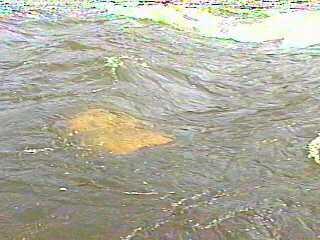
Occasionally, some rocks will find their way randomly into the main channel (such as the submerged white block shown in the photo on the left). As of summer/fall of 2003 the pool downstream of Showboat is completely clear of any rock (other than the previously mentioned uplift and shallow rock in the river-right eddy) until about 3/4 of the way back to the next pitch and the obvious (at least at lower water) shallower rubble causing the irregular rapids and waves there. Spring ice-out and high flows may cause some rocks to migrate, so there is no guarantee of this area remaining clear.) Due to the swift current in this area of highly channelized river, and the large rocks on/near shore, foot entrapments could be likely. Do NOT attempt to stand-up in the river at any but the lowest flows! Eddies are minimal, especially as flows increase. Shrub willows growing throught the streambank rip-rap will be in the water, which complicates getting ashore through much of this stretch at levels above 1000cfs. |

|
| There is one other site (on this river, within Milwaukee County) which folks may be aware of and could be of potential interest to whitewater boaters. A 3-4' very irregular ledge/dam exists in Kletsch Park (Milwaukee River Parkway, between Silver Spring and Good Hope). While there are a great many ways one could run the dam/ledge/falls, there appears to be extremely limited opportunity for any significant play. At flows above 1500cfs or so, this has a nasty reversal. Access (for park-and-play boating) is (as far as I know) illegal (per Note#2). The spot is very visible from the parkway, and is popular for fishing. Downstream, there is a minor amount of swiftwater, with no notable, playable features, and one is soon upon the wide open, flat backwater from the Hampton Avenue dam. You will have dead-flat water (at least in late-spring/summer, when the Hampton Avenue dam is closed and the pond is up) until you reach the generally boated section as described above. For all these reasons, I strongly advise against boating this highly visible location. (Extreme caution urged to any who may choose to try it.) |