![]()
![]()
| Return to the "Put-in" (Home page) | Format of descriptions | Disclaimers |
| RIVER: | Milwaukee River, Newberg section |
| LOCATION: | Newberg, WI |
| AMENITIES: | Click for Saukville/Newberg/Port Washington Area Amenities (food, lodging, etc.) |
| PUT-IN: | county park at corner of CTH.M & Hwy.33 |
| TAKE-OUT: | Waubeka Veterans Park, at former dam-site |
| ALT.TAKE-OUT: | CTH.A bridge |
| SHUTTLE: | EITHER: CTH.A west 3.5 miles to CTH.M, left (south) 3 mi.
OR: CTH.A west 0.5 miles to CTH.Y, left (south), zigging and zagging to stay on 'Y' to Newberg. There, take Hwy.33 right (west) 2 miles to CTH.M. |
| DIST: | 12.5 miles (9.0 miles) |
| TIME: | 5 hours (under 4hours) |
| CLASS: | 0 (III) |
| CHARACTER: | Flowing river with a couple shoals and a dam (III/portage) |
| GAUGE: | U.S.G.S. gauge: min=?, opt=?, high=? |
| SEASON: | Generally runnable except during prolonged dry spells. |
| Good flowing river, with a few shoals areas (class I), and a possibly runnable 3-4' dam (class II-III) right under the highway at Newberg (mile 3). There is a left side 'apron' which would form a fun slide or a left-center 'boof' line. Center to river right all lands on rock. A far right side separate sluice channel could be very interesting, as it drops over about a 1' wooden gate, channels down through a box/culvert with some diagonal wave action inside, then upon exit piles against a wall that could be tricky (nasty). A small pool leads to another pourover (with a rock on the left) into a short, swift rocky channel returning to the main river. Recommended scout/portage left or right.
Scenery and flow continue as the river passes the 'Riveredge Nature Center' north of town, and past a farmstead with a small rubble-dam for a short thrill. Beyond the CTH.A bridge (mile 9) the river is wider and shallower, so at low flows there will likely be some dragging your boat (up to 1.5 mi.) if you proceed to the listed take-out. |

|
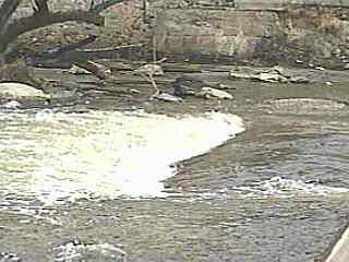
| As of Fall of 2001, a dam at the takeout in Waubeka has been breached and will be removed. At present, a single pocket-wave/hole has formed (shown above). Depending how the bedrock and rocks are left upon removal of the dam, there could be a short stretch of shallow, low-grade boulder-bed rapids left here. |