![]()
![]()
| Return to the "Put-in" (Home page) | Format of descriptions | Disclaimers |
| RIVER: | Sauk Creek |
| LOCATION: | Port Washington, WI |
| AMENITIES: | Click for area amenities (food, lodging, etc.) |
| PUT-IN: | Grant Street, alongside school athletic fields and gravel parking area |
| ALT.PUT-IN: | Nature Preserve (park) at 3210 Moore |
| TAKE-OUT: | S.Milwaukee Street (just short of Port Washington Harbor) |
| MAP: | Sauk Creek (Will open new window. Close it to return here.) |
| SHUTTLE LENGTH: | 1.4 miles, 5 minutes |
| SHUTTLE: | Left (E.) 1 block to S.Wisconsin Street, left (N.) 2 blocks to Main (Grand Ave.), left (W) 3 blocks to N.Webster, right (N) 4 blocks to VanBuren, left (W) 1+ block to Holden, right (N) 3 blocks to Walters, left (W) 0.2mi. to Grant, right (N) to athletic field parking lot, then carry in on path through the woods.
Otherwise, to the alt.put-in: S.Milwaukee Street 1 block S. to Chestnut, right (W.) 3 blocks to Webster, right (N.) 1 block to Main (Grand Ave.), left (W) 0.4 mi to Moore, right (N) 0.6 mi to 3210 Moore, where a new city park exists where you may park and carry up above the falls. |
| DIST: | 1.5 miles |
| TIME: | 1 hour |
| CLASS: | II (III)
Note: due to narrow channel and liklihood of strainers, extreme caution is urged. Many places contain cement rubble which may contain rebar. Be alert. Do not boat this alone or with only inexperienced paddlers (especially at moderate to high flows). |
| CHARACTER: | 'continuous' class I-II, bordering on III for a stretch. City canyon run. |
| GRADIENT: | 40 fpm ave.; 50' in just over 0.6 mile for about 80 fpm max! |
| GAUGE: | Visual. The best place to 'gauge' this creek is at the nature preserve, where the main gradient is concentrated. If it looks boatable here, go for it! This will happen seldom, only when all else in the area is quite high.
May correlate somewhat to Cedar Creek gauge, which will probably have to be very high (600? 1000?), though better 'gauge' will be 'gut feel' based on rain reports and weather radar. |
| SEASON: | Generally runnable only in early spring or after heavy summer rains. |
|
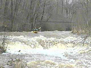
| Good flowing water will lead you quickly to an old three-rail iron bridge (background, above left). You will hear a falls and see a horizon line and the foot-bridge in the nature preserve (photo below left). This is the biggest drop on the run, about 7' total drop, with the main drop being about 4'. Water sheets downstream on the sloping bedrock so quickly (and shallow) that you are likely to 'grunge' a bit here. The landing zone in the center of the main drop is generally shallow, making a route to either side of center advisable at most levels. A short ledge just before the bridge may allow some play (above right). |

|
|
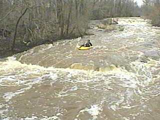
Immediately downstream extending about ¼ to ½ mile, a series of bedrock slides and rubble shoals create waves which may allow some play at moderate water levels. Again, more likely one will just carry up to enjoy the experience of (re)running this relatively 'steep gradient' sequence.
Caution!!! There is a cable which spans the river midway down this 'second pitch'. At low-to-moderate water levels it should be well enough overhead, but at higher water it may become a hazard, expecially if/when it happens to accumulate some wood and debris which pull it down a bit more than usual. It is highly recommended to check this out before putting in for the run. The cable is visible by looking (closely) downstream from the footbridge. Generally, a run staying left is advisable, as the cable tends to sag to the right. |
|
|
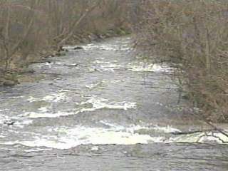
The remainder of the run is good flowing water, with areas of channelization resulting in some compression waves. Be alert for strainers and snags, as well as trees which grow in or near the river and have branches which hang down. With high, swift water, negotiating some areas can be tricky and somewhat treacherous.
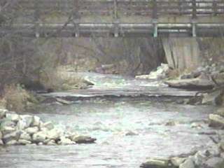
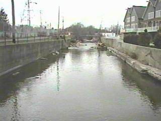
Take out is signaled by a corrugated iron retaining wall and the towers for the high-tension power lines, or proceed to the final roadbridge (shown above left). Boating beyond the roadbridge is inadvisable. The river becomes walled in (as shown above right). |

|
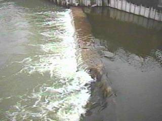
 At the mouth, a small wall/dam (shown above left) does create a sweet looking wave (at boatable levels). However, the broken-down left side of the wall (visible above) shows the exposed iron wall and rebar (detailed at left) which will be hidden in the flow at boatable levels.
Additionally: 1) Fishermen love this area, and tend to congregate at the retaining wall on river-right, 2) there are potentially wicked currents due to power-plant outflow river-right, and 3) there is no easy egress, other than paddling through the harbor to the boat ramp or climbing over large rock jumble shoreline. So, again, it is advisable to exit the river at the previously mentioned bridge. |