![]()
![]()
| Return to the "Put-in" (Home page) | Format of descriptions | Disclaimers |
| RIVER: | Sheboygan River |
| LOCATION: | Sheboygan Falls |
| AMENITIES: | Click for area amenities (food, lodging, etc.) |
| PUT-IN: | dam, in downtown Sheboygan Falls |
| TAKE-OUT: | river right parking lot near apartment complex |
| SHUTTLE: | From dam proceed S.E. to parking. |
| DIST: | 1.0 miles |
| TIME: | PnP (as long as you can entertain yourself) |
| CLASS: | II-IV |
| CHARACTER: | Short, in town section with a series of ledges. |
| GRADIENT: | ~50fpm for 0.5 miles |
| GAUGE: | U.S.G.S. gauge: min=1000, opt=1500, high=2500
I have boated this reach only once (at about 1500cfs) so gauge info is mostly a guess. The following description is based on investigations of this reach with the river at levels too low to run (about 250cfs and 680cfs). |
| SEASON: | Probably early spring and heavy summer rains. |
| ANALYSIS: | Min.=1 cfs; 90%=38 cfs; 10%=613 cfs; Max.=7000 cfs; 10/90=16.1
> 500 cfs = 55 days/yr, /32yrs > 750 cfs = 31 days/yr, /32yrs > 1,000 cfs = 20 days/yr, /32yrs > 1,250 cfs = 13 days/yr, /32yrs > 1,500 cfs = 9 days/yr, /32yrs > 2,000 cfs = 4 days/yr, /32yrs |

|
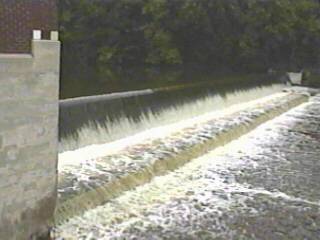
| A dam at the top of this reach drops 7' into a 'stilling wll' area which (at low water, above left) has a nasty looking, uniform reversal, backed up by a short wall, over which the water cascades another 1.5' into another uniform reversal. At levels which make the rest of this section runnable, this gets real interesting (above right) as the water sheets across the splash pan and spews up off the lower wall into what almost looks like water churning off a paddle-wheel. |


|
|
The leftmost part of the dam drops 6' onto uniformly shallow bedrock (above left). Even at high runnable flows (above right), this looks like it could be painful to run since the water sheets shallow and fast across the bedrock.
A better choice for put-in is river-right, below the dam, where a new city park has been created after removal of old building foundations. The river spreads out wide across uniformly shallow bedrock. About ten yards below the dam, a fast surf wave forms. This will be surf-on-the-fly, or (at some water levels) attain up the slackwater behind the hole. Immediately after that hole, head well to the left to catch a pocket wave which allows side-surfs, spins and blasting. As the river passes under a highway bridge, a short (1.0-1.5') ledge is encountered. The sloping bedrock will probably sheet the water away too swiftly to allow any real play here, but scouting ahead of time should verify where you want to be here, just in case. |

|
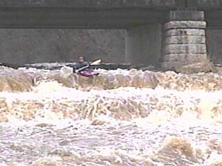 Just beyond the side-by-side highway and railroad bridges, the river encounters the biggest ledge. On river-right there are two large steps. The upper drop is 6-7' and lands on a ledge about that wide before dropping another 4-5' in what looks likely to be a painful combination. Center-river or river-left make a much better line, as the bedrock slopes to somewhat diminish the effective height of the ledges.
|
 About 20 yards downstream of the big ledge/drop, a great diagonal wave forms. With determination and skill it should be possible to stall and surf across on this wave. Good boat control will be needed to ride this fast surf, otherwise you'll likely be rubbing shoulders with the brick wall of the old mill (background of photo).
Again, the sloping shallow bedrock sheets the water downstream quickly. Center river contains some interesting looking waves (they would form up about center frame in this low-water photo). Surfing them will take either considerable skill and courage or stupidity due to what lies downstream. |
 There is a pronounced right-to-left tilt to the bedrock, so start well right in order to stay more center-to-right for the final (2-3') ledge. At good flows, the left side will form a nasty hole (background of photo at left), while center or right will be much more forgiving (nearground in photo).
A short stretch of swiftwater will bring you to the parking area for your take-out. |


|
 Note: There are additional upstream reaches of this river which consist primarily of flat/swift water punctuated by brief areas of potentially runnable/playable rapids formed by dams and/or former dam sites. Notably, a dam removal site in Franklin (pretty much just swiftwater, but great to see an area regenerating to it's natrual (pre-dam) condition), and a dam/wave at a park in Johnsonville (yup, as in Johnsonville brats, whose plant is right across the street from the park) make a 4 ½ mile reach from FF to J potentially interesting.
|