![]()
![]()
| Return to the "Put-in" (Home page) | Format of descriptions | Disclaimers |
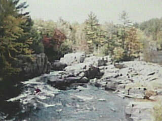
| RIVER: | Eau Claire River, Dells section |
| LOCATION: | Marathon County, 15 mi.E. of Wausau, 9 mi.S.W. of Antigo |
| PUT-IN: | Above the dam in the south parking lot area |
| TAKE-OUT: | Immediately below the dells |
| SHUTTLE: | Walk it, or drive from one parking lot to the other |
| DIST: | ½ mi |
| TIME: | How much do you play? |
| CLASS: | II-IV |
| CHARACTER: | A beautiful dells, with numerous 'T' and 'L' turns, short rapids and pourover ledges. |
| GAUGE: | U.S.G.S. @ Kelly (16mi.downstream); min.=125,opt.=500cfs |
| SEASON: | Usually run only in early spring or after heavy rain. Can provide some play most of the year. |
| ANALYSIS: | Min.=25 cfs; 90%=60 cfs; 10%=536 cfs; Max.=7,180 cfs; 10/90=8.9
> 350 cfs = 66 days/yr, 22/22yrs > 750 cfs = 22 days/yr, 21/22yrs > 1,300 cfs = 9 days/yr, 19/22yrs > 2,000 cfs = 3 days/yr, 17/22yrs > 3,000 cfs = 1 day/yr, 8/22yrs |

Starting in the pool above the dam, you'll run the right side of the dam, down a channel that twists to the left. Several easy playable rapids and waves precede the drop under the road and into the dells proper. |
Just beyond the road there is a large rock island with up to three options, depending on the flow and your interest. |

Option 1: The main flow generally goes river left to a wall on the left, then about 25' to a sharp pourover ledge into a large aerated pool. The reversal at this ledge is substantial enough to back-ender open canoes with ease. |

This river channel makes a 'T' type intersection almost immediately on another large rock/island (the reason for the aerated pool). At high flows this is an UGLY, boiling caldron! The left channel here is often full of snags, making it a poor choice. The right channel proceeds about 25' to another wall of rock where it is diverted 90-degrees to the left. The tight quarters and strong currents can make negotiating this move rather tricky. Into this churning pool, drops option number two. |

Option 2: A small center channel (at moderate to high water) leads immediately right of the main rock/island. (At normal spring flows this will be about paddle-width.) It stays high until dropping 3-4' into the aforementioned pool. This makes an mildly impressive kayak run as you boof into the froth. It also gives you a straight-forward line on the next slot. At lower flows (but still enough to have water in this channel), be aware that the end of the slot contains a rock, set at an odd angle. A significant amount of water "siphons" down under this rock. It should not be a problem for most boats at runnable levels. |
 Flowing out of this pool, the river is squeezed to barely paddle width again, and then flows out to several channels and slots of which the boater may take his/her pick. A funky little 'chicken-ender' spot can be found in the third slot-channel, making some play possible even at low summer/fall levels. You are now in the coliseum of the dells, an awesome place.
Option 3: At higher flows, water will pour over all the rocks to the right of the rock island. If you choose to run, you will probably wish to stay well to the right to avoid the holes and piton potential center and left. This is the recommended take-out. Downstream from here, there are a few minor rapids (class I), and it is possible to make a longer run (to either of the next highway bridges, 2.0 miles or 5.5 miles downstream), but the most awesome scenery and action is right in the park. |