 The main reason to run (or not to run) this stretch of river is the existence of two awesome gorge/falls. About 10 minutes of easy paddling brings you to a left hand bend, a pool and an obvious narrowing, where you will hear the water pounding through Smalley
Falls. Take out river right to scout/portage. This narrow, plunging gorge could be run by the right people at the right level with the right precautions.
The main reason to run (or not to run) this stretch of river is the existence of two awesome gorge/falls. About 10 minutes of easy paddling brings you to a left hand bend, a pool and an obvious narrowing, where you will hear the water pounding through Smalley
Falls. Take out river right to scout/portage. This narrow, plunging gorge could be run by the right people at the right level with the right precautions.
|
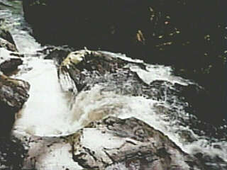 A series of ledges and rocks (which should cause an experienced paddler no problems) on the first 2/3 of the drop leads to a large platform rock perched on the left above a narrow, double-undercut slot.
|
 Center river is a backbone of rock which (in concert with the platform rock previously mentioned) diverts much of the flow to the right, where it boils against a rock wall (no undercuts or other apparent concerns) to funnel down to meet the flow from the double-undercut slot and form a significant hole as you hit the bottom of this awesome jumbled slide. (Probably class IV; maybe about 15-20' drop in 100' of run). (Note: there is now a small county park and trail for easy access for non-boaters to view this falls.)
|
 Action then subsides to class II-III smaller drops and occasional snags, before flattening out altogether until another obvious narrowing and thundering falls.
|
 This is Long Slide Falls. Un-runnable at any level by anyone who values their boat and their body. Take out on the left, well above any action here, and have a look at a most impressive falls in a surprising little gorge.
|
 The trail back to the parking lot is the best choice from here, but if you do proceed, portage around the falls and down the bluff (a class IV carry). A short shoals is followed by a pool and huge tree across the river. Portage right, and proceed around the bend to a short class II-III ledge drop. Beyond this, action subsides to flat water, interrupted by occasional class II action, and much more frequent snags to be wary of.
Beyond the short rips at Timms Lake Road there is virtually no significant action (save for a very short drop at a power line at mile 8), and there are continued snags until the confluence with the south branch (not so designated officially). Snags almost completely diminish after the confluence, and though the volume is increased, the gradient and scenery are diminished.
|