![]()
![]()
| Return to the "Put-in" (Home page) | Format of descriptions | Disclaimers |
| RIVER: | Pike River, N.Branch, Dunbar section |
| LOCATION: | Marinette County, near Dunbar, on U.S.Hwy.8 |
| PUT-IN: | Old County A Road |
| ALT.PUT-IN: | C-C-C Camp Road |
| TAKE-OUT: | Twin Lake Road |
| SHUTTLE: | Twin Lake Road west 3.5 miles to Old County.A Road.
EITHER left (S) 1.6 mi to 4-Corners road, then right (W) 2.2 mi. to C-C-C Camp Road, right (N) 3.5 mi. to the river. -OR- right (N) 1.1 mile to river (alt.put-in) (N) another 1.3 mi to U.S.8, left (W) 0.5 mi to Dunbar and C-C-C Camp Rd, then left (S) 2.0 mi to the river. |
| DIST: | 4.5 (7.0) miles |
| TIME: | 2.0 (4.0) hours |
| CLASS: | 0 (III-IV) |
| CHARACTER: | Flat water, easy rapids and a recommended portage. |
| GAUGE: | U.S.G.S. gauge (well downstream, after confluence with S.Branch); min=?, opt=?, high=?
The culverts at CCC Road are constructed of curved sheets of corrugated metal bolted together. There are 6 holes between the bolted joints. Minimum should be considered about the sixth hole. Probably desirable to have the gauge at Hwy.141 bridge (well downstream, after combining with the S.Branch) at 1' or better. |
| SEASON: | Almost always runnable, but best in spring or after heavy rain. |
| ANALYSIS: | (Note: data for combined flow of N.Branch and S.Branch, well downstream.)
Min.=70 cfs; 90%=100 cfs; 10%=370 cfs; Max.=2130 cfs; 10/90=3.7 > 300 cfs = 54 days/yr, 41/41yrs > 600 cfs = 11 days/yr, 37/41yrs > 900 cfs = 2 days/yr, 21/41yrs > 1,200 cfs = 1 day/yr, 8/41yrs |
 The river from C-C-C Road to Old County A is uniformly flat but
flowing, with no obstructions of any sort (vegetable, mineral, or elevational),
save for a small rock dam about half way which is easily run to the left.
The river from C-C-C Road to Old County A is uniformly flat but
flowing, with no obstructions of any sort (vegetable, mineral, or elevational),
save for a small rock dam about half way which is easily run to the left.
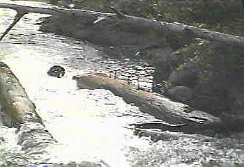
At Old County A, Carney Rapids drops into a mini-gorge (right under the road bridge) which would be a sweet, straight-forward drop, except that there are huge timbers embedded in the rock which have huge spikes sticking out of them. Additionally (when I was there at low water) there is a large log in the pool at the base of the drop, angled diagonally up toward the drop, ready to hammer anyone / anything coming down the drop. This makes this a highly recommended portage. |
 About a half mile of flat/flowing water with intermixed easy rapids lead a to another interesting drop, Four-Foot Falls. A 1.5-2.0' ledge is a straight-forward run right or center, or a twisting run river left toward center. Almost immediately beyond this ledge is a weird slot against the left wall. At low water, all the flow drops about 2.5' into this slightly more than boat-width slot. At higher flows, another path down a somewhat more inviting ledge/falls would be available on river right.
Beyond this, the run consists of easy shoals, flat water, and snags until the take-out. I have not paddled the river between the listed take-out for this reach and the put-in for the "Four Falls" section. There is very little to suggest that it contains anything but flatwater (and likely deadfall), so it is not likely of interest to any whitewater paddlers. Note: Vidcaps (photos) from low-water scout (1992.09.13). |