![]()
![]()
| Return to the "Put-in" (Home page) | Format of descriptions | Disclaimers |
| RIVER: | Pike River, N.Branch, Four Falls section |
| LOCATION: | Marinette County, between Amberg and Dunbar |
| PUT-IN: | Twin Lake Road |
| TAKE-OUT: | Twelve-Foot Falls County Park |
| SHUTTLE: | From Twelve-Foot Falls County Park entrance road, proceed right (N) 2.5 mi to Twin Lake Rd, right (E) 0.1 mi to the river. |
| DIST: | 3.5 miles |
| TIME: | 2-3 hours |
| CLASS: | II-IV |
| CHARACTER: | Flat water and big steep-slide falls (pool/drop). |
| GAUGE: | U.S.G.S. gauge (well downstream, after confluence with S.Branch); min=300, opt=650, high=800 Actual flow in this reach will be approximately half of gauge reading. |
| SEASON: | Falls are runnable in spring, the rest is runnable most of the year as a flatwater paddle to see the falls (though the three largest of them are readily accessable from access roads and a county park). |
| ANALYSIS: | (Note: The data is for combined flow of N.Branch and S.Branch, well downstream)
Min.=70 cfs; 90%=100 cfs; 10%=370 cfs; Max.=2130 cfs; 10/90=3.7 > 300 cfs = 54 days/yr, 41/41yrs > 600 cfs = 11 days/yr, 37/41yrs > 900 cfs = 2 days/yr, 21/41yrs > 1,200 cfs = 1 day/yr, 8/41yrs |
|
| After 10-15 minutes of typical midwest river flat but flowing water you will see a house river-left with a footbridge across the river and hear the first drop. Take out on the right (respect property owners rights) to scout Bull Falls. The action starts with some easy waves under the bridge then drops down and dog-legs sharply left. The bottom of the drop features a wave which might provide some minor play. After this drop there is a small pool, and class II action for a short distance around the bend. |
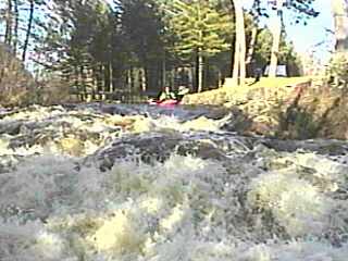
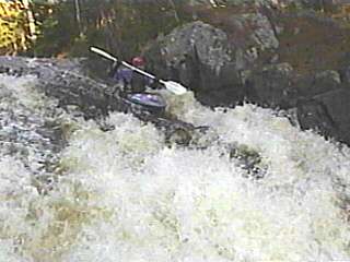
 About 10 minutes of flatwater brings you to 18'falls. Recommended take-out on the left bank to scout this pitch. Jagged bedrock causes the falls to be a be a bit of aerated froth. There is a large pool at the base, from which the river escapes to the right, down class II rapids, past rock outcroppings on the right.
 |
|
|
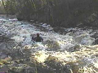
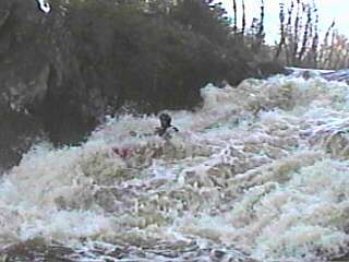
Another 10 minutes brings you to a small island with the right side generally debris choked and the left side narrow and swift. Take-out above this island river right (or below the island if you are real confident in catching the last-chance eddy above the falls) to scout 12'falls. The swift left channel contains a couple ledges which could provide play elsewhere, were it not for the falls below. This falls is also formed by very jagged bedrock, causing another frothy falls. The left side carries a deeper channel of water, the center has a spline of rock jutting up, and the right side has a rock with an upturned lip which shoots the water up to fall onto a jumble of rocks at the base of the falls. There are some rather shallow submerged rocks on the left side of the base of the falls, just about a boat length out from the base. Generally they are well enough out-of-the-way so that you should not encounter them on a left-side run, but you may wish to make certain to finish the drop with a slight right-angle, just in case.
A huge pool sits at the base of this falls, across from which is the picnic grounds and parking lot for the park. Don't get out yet! There is one more falls just around the bend! |
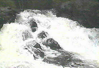
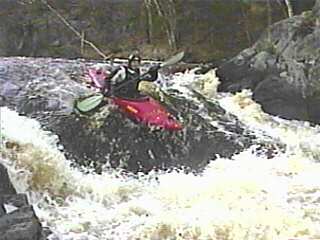 After passing a small tree-filled island, the river takes a sharp left bend, drops over a few small bedrock intrusions (with minor play potential) then takes a sharp right to drop down 8' falls. A large hump of rock (on the left) channels the river over a fairly uniform sloping ledge into another large pool. At high water the hole at the base gets VERY uniform, though at the right flows it could provide some entertainment.
This is the recommended take-out, since the river is uninteresting until the next described section. Note: Vidcap (photo) above left is from low-water scout (1992.09.13). Remainder of photos are from run at 660 cfs. (2002.04.20) |