![]()
![]()
| Return to the "Put-in" (Home page) | Format of descriptions | Disclaimers |
| RIVER: | Red River, West Branch |
| LOCATION: | Stockbridge Indian Reservation, 18 mi. NW of Shawano, 7 mi. S.W. of Neopit |
| PUT-IN: | County park on Reservation Road
A Tribal Sheriff lives (or, at least, did at the time of our 'exploratory' in 1994) across the river from this park. When we explored this run, he volunteered to allow us to park in his driveway, citing occasional vandalism which has occurred in the park. This was good news and bad news. (1) It indicated that we were not considered to be "trespassing" to run the river (as in the Menominee Reservation) but (2) It meant that some of the tribe members may be no more "friendly" than some in recent experience in the Menominee Reservation.) Note: This entire reach lies within the Stockbridge-Munsee (Mohican Indian) Reservation, and is thereby controlled by their tribal law. In recent years, I have received information that members of the tribe have become much more protective of their lands. While it may be possible to obtain permission to run the river from tribal sheriff or other tribal officials to prevent being cited for trespass on reservation lands, in general it is far more likely this reach should be considered 'off-limits'. |
| TAKE-OUT: | Morgan Road (standard take-out for Upper Red River run) |
| SHUTTLE: | From the junction of Morgan Road and C.T.H. A, proceed W on CTH.A. At 0.5 mile, it jogs N for 0.5 mile, then continues W another 4.5 mile to the intersection with Reservation Road. Turn right (N) 3.6 miles to river and park. |
| DIST: | 5.0 mi. |
| TIME: | 2.5 hr. |
| CLASS: | I-III+ |
| CHARACTER: | Pool/drop. |
| GAUGE: | U.S.G.S. @ Morgan (on main Red River downstream); min=?, opt.=500cfs, max=? |
| SEASON: | Early spring or after heavy rain. |
 From the put-in, a braided channel trips through easy rapids. The run
is mostly flatwater, punctuated by a couple interesting, twisted drops.
Unfortunately, due to the nature of this small stream, many of the drops
are 'wooded up,' making them unrunnable.
From the put-in, a braided channel trips through easy rapids. The run
is mostly flatwater, punctuated by a couple interesting, twisted drops.
Unfortunately, due to the nature of this small stream, many of the drops
are 'wooded up,' making them unrunnable.
|
|
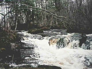
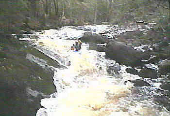
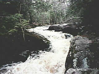
The best action comes 0.6 mile upstream of the confluence with the main branch of the Red, where the river slides through a twisted channel in a fun class III-ish flume. (For those familiar with the Upper Red, this confluence is a very short distance downstream from Suzie's Falls.) Note: Vidcap (photo) from low-water scout (1994.04.30). While this run could be combined with a run on the Upper Red, generally you will probably opt to not bother with the West Branch, and do the Upper Red in combination with Tigerton Dells, and/or Hayman Falls. |