The best known of all the trails that descend to the bottom of the canyon, is the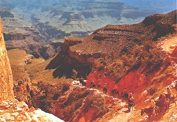 Bright Angel Trailhead. The trail was originally use as a path for big horn sheep, before being used by the Havasupai Indians. In 1891, it was widened for prospectors. Today, it is well maintained as a route for mule and pedestrians. The trail descends to the Colorado River, 5,510 feet below the rim. The park has guided hikes down to the bottom, or if desired, hikers that are properly equipped may venture down on their own, after notify in park representatives in advance. Bright Angel Trailhead. The trail was originally use as a path for big horn sheep, before being used by the Havasupai Indians. In 1891, it was widened for prospectors. Today, it is well maintained as a route for mule and pedestrians. The trail descends to the Colorado River, 5,510 feet below the rim. The park has guided hikes down to the bottom, or if desired, hikers that are properly equipped may venture down on their own, after notify in park representatives in advance.
The El Tovar Hotel sits on the South Rim of the Canyon. It was named for Don Pedro de Tovar, the Spanish explorer who visited with Hopi tribes in 1540. He did not make it into the Canyon himself, but reported its existence to others. It was built by the Fred Harvey Company in 1905. The architect, Charles 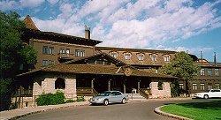 Whittlesey used Oregon pine, and stone native to the area to design the hotel in a European hunting lodge style. His plans blended the styling techniques of Swiss chalets and German castles. His finished design was an enchanting hotel that complemented the natural beauty of the Canyon, and became the first example of rustic architecture within a national park. In addition to being listed on the National Register of Historical Places, the El Tovar is well-known for it's world class dining. The dining room overlooks the Canyon, offering stunning views to diners as they tease their palettes with savory cuisine. Whittlesey used Oregon pine, and stone native to the area to design the hotel in a European hunting lodge style. His plans blended the styling techniques of Swiss chalets and German castles. His finished design was an enchanting hotel that complemented the natural beauty of the Canyon, and became the first example of rustic architecture within a national park. In addition to being listed on the National Register of Historical Places, the El Tovar is well-known for it's world class dining. The dining room overlooks the Canyon, offering stunning views to diners as they tease their palettes with savory cuisine.
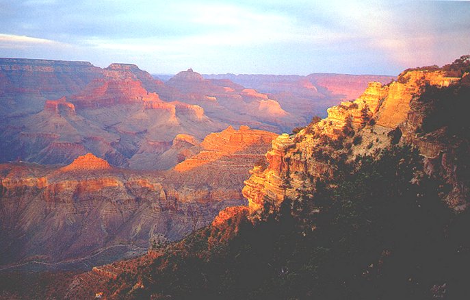
Yaki Point, on the east section of the canyon, offers a view of Wotan's Throne, a flat-top butte named by Francois Matthes, who developed the first topographical map of the canyon. In addition, this vista overlooks Buddha Temple and Newton Butte, displaying the their unique limestone and red sandstone qualities. The start of the Kaibab Trail is located at Yaki Point. The trail descends to the Inner Gorge, then crosses the Colorado River over a steel suspension bridge that leads to Phantom ranch, the only lodging facility at the bottom of the canyon. flat-top butte named by Francois Matthes, who developed the first topographical map of the canyon. In addition, this vista overlooks Buddha Temple and Newton Butte, displaying the their unique limestone and red sandstone qualities. The start of the Kaibab Trail is located at Yaki Point. The trail descends to the Inner Gorge, then crosses the Colorado River over a steel suspension bridge that leads to Phantom ranch, the only lodging facility at the bottom of the canyon.
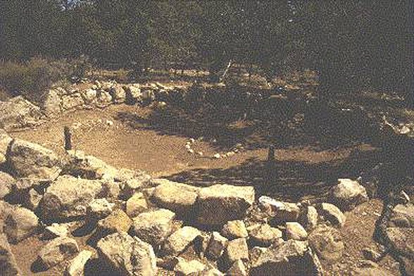
The Tusayan Ruins and Museum, on the south side of the highway that runs along the south rim, presents evidence of early habitation in the canyon. The word, Tusayan, is a Hopi phrase meaning "country of isolated buttes". The ruins center around partially intact rock dwellings that were occupied by about thirty Indian hunters, farmers and gatherers, for roughly 20 years around A.D. 1200. The Indians moved on elsewhere due to drought and depletion of natural resources. Information, artifacts, models of dwellings and exhibits on modern tribes of the region are located in the museum. along the south rim, presents evidence of early habitation in the canyon. The word, Tusayan, is a Hopi phrase meaning "country of isolated buttes". The ruins center around partially intact rock dwellings that were occupied by about thirty Indian hunters, farmers and gatherers, for roughly 20 years around A.D. 1200. The Indians moved on elsewhere due to drought and depletion of natural resources. Information, artifacts, models of dwellings and exhibits on modern tribes of the region are located in the museum.
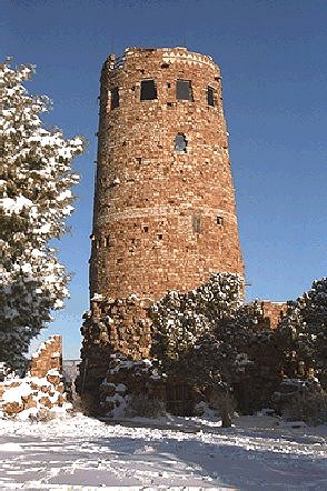
At the eastern end of the southern rim, sits the Desert View and Watchtower.  The watchtower was built in 1932 as a joint venture of the Santa Fe Railroad and the Fred Harvey Company. Standing over 70 feet, and made of stone and mortar, the watchtower was designed as in the style of a Native American structure. Within the watchtower is a glass-enclosed observatory with powerful telescopes. Visitors are welcomed to use the telescopes, that allow you to view the Painted Desert in the distance, and the Vermilion Cliffs, which rise 3,000 feet from a high plateau near the border of Utah. Below, and toward Marble canyon in the north, a large treacherous stretch of the Colorado River is visible. The watchtower was built in 1932 as a joint venture of the Santa Fe Railroad and the Fred Harvey Company. Standing over 70 feet, and made of stone and mortar, the watchtower was designed as in the style of a Native American structure. Within the watchtower is a glass-enclosed observatory with powerful telescopes. Visitors are welcomed to use the telescopes, that allow you to view the Painted Desert in the distance, and the Vermilion Cliffs, which rise 3,000 feet from a high plateau near the border of Utah. Below, and toward Marble canyon in the north, a large treacherous stretch of the Colorado River is visible. |