


|
MALABON |
|
INTRODUCTION |
|
Malabon is one of the Philippines' oldest municipalities and one of the economic powerhouses of the nation. It's blessed with sun-drenched natural attractions, sturdy business establishments, long stretches of rich and heavenly coasts, a strong economy, a stable local government, and a population of open-minded, and friendly folk of outgoing entrepreneurial types who are itching to show the whole place off. |
 |
Malabon, with its inhabitants, conveys a sense of life and energy that is immediately apparent. This dynamism is echoed by the city's geographical position: a great plane curbing by the blue sea with dramatic terrain behind it. A city with a venerable past, it was a thriving town even before the Spanish regime. It has a rough and ready energy and offers an invigorating blend of the old and the new, the raw and the refined. Having a happy blending of the old and new architectural trends, Malabon has been developing fast as a modern city and is throbbing with activities in all spheres of life, be it industrial, commercial , cultural or political. |
|
HISTORY |
|
Originally, the town of Tambobong, Malabon was founded as a “Visata” of Tondo by the Augustinian friars on May 21, 1599 and remained under the administrative jurisdiction of the province of Tondo from 1627 to 1688. Malabon was officially made a municipality of the newly created province of Rizal on June 11, 1901 by virtue of Philippine Commission Act 137. |
|
|
When Philippine Commission Act 942 was promulgated, Malabon was combined with Navotas under a new government. On January 6, 1906, Philippine Commission Act 1441 separated Malabon from Navotas into two distinct municipalities of the Rizal province. For 70 years, Malabon was a municipality of Rizal, until November 7, 1975, by virtue of Presidential Decree No. 824, when Malabon became a part of Metropolitan Manila or the National Capital Region. |
DESCRIPTION |
|
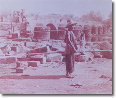
The city of Malabon was an important literary center of the revolutionary Filipinos during the period of Spain's colonization of the Philippines, which ended with the revolution in 1896. It was here, in Malabon's Asilo de Huertanos, that the La Independencia, the voice of the revolutionary government, was printed. On the same site were housed children who had been orphaned due to the plague of 1882. |
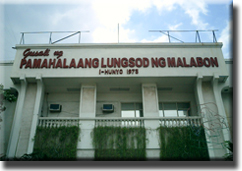 A picture of the City Hall of Malabon |
Today Malabon has become a coastal city situated in the northern part of Metro Manila. Malabon, together with Navotas, Valenzuela, Pateros, Taguig, Pasig, and Muntinlupa, form the Metro Manila outer ring of towns, with the city of Manila as the center. |
|
GEOGRAPHY |
|
The town of Malabon is basically a coastal town situated in the northern part of Metro Manila. Malabon, together with Navotas, Valenzuela, Pateros, Taguig, Pasig, and Muntinlupa, form the Metro Manila outer ring of towns, with the city of Manila as the center. The municipality is bounded on the north and northeast by Valenzuela, on the west and southwest by Navotas, and on the southeast by Caloocan City. It occupies a total land area of 23.4 square kilometers. |
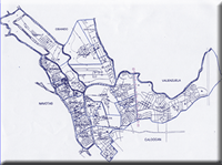 Click for larger picture |
>>next |
|

No part of this website may be copied or reproduced in any form without the prior written consent of the webmaster.
All Rights Reserved 2004. Email the webmaster.