At Warning Center, Alert for the Quake, None for a Tsunami
By MICHELE KAYAL and MATTHEW L. WALD
Published: December 28, 2004
HONOLULU, Dec. 27 - When experts at the Pacific Tsunami Warning Center in Honolulu were first alerted that an earthquake had struck Sunday off Indonesia, they had no way of knowing that it had generated a devastating tsunami and no way to warn the people most likely to suffer.
Tsunamis are rare in the Indian Ocean, which has no system for detecting them and alerting those in danger, and scientists do not have the tools to tell when an earthquake has created one.
Not until the deadly wave hit Sri Lanka and the scientists in Honolulu saw news reports of the damage there did they recognize what was happening.
"Then we knew there was something moving across the Indian Ocean," said Dr. Charles McCreery, the center's director.
"We wanted to try to do something, but without a plan in place then, it was not an effective way to issue a warning, or to have it acted upon," Dr. McCreery said. "There would have still been some time - not a lot of time, but some time - if there was something that could be done in Madagascar, or on the coast of Africa."
"One of the things that was running through my mind is just that our international group has in many past meetings had discussions about what can be done for other ocean basins," he said. "And I guess I was just wishing in retrospect that more progress had been made in that area."
The sequence of events as knowledge of the earthquake, the tsunami and the destruction unfolded suggest the speed and precision of science and modern communication, as well as their limits. If there had been a warning system for tsunamis in the Indian Ocean, thousands of people might have had a chance to flee.
The first notice of the earthquake that anyone at the Pacific tsunami center received was a computer-generated page set off by seismic sensors at 2:59 p.m. on Saturday Honolulu time. The immediate message received by people like Laura S. L. Kong, a Department of Commerce expert who is the head of a United Nations tsunami education center in Hawaii, included the time of the quake, latitude, longitude and an initial estimate of magnitude, about 8.0.
Nobody was in the office of the Pacific tsunami center. But staff members who received the pages reached the office, took a closer look at available data and sent out a warning to a preset list of contacts around the Pacific.
The center was advising of sea level changes in Fiji, Chile and California measured in inches, the echo of a distant event that had sloshed through the straits that connect the oceans. The warning center continued to refine its estimate of the quake, eventually raising it to a magnitude of 9.0, which is 10 times more powerful than the initial estimate of 8.0, because the scale is logarithmic.
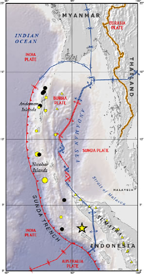
The Pacific center, operated by the National Oceanographic and Atmospheric Administration, faced two problems in recognizing what was occurring in the Indian Ocean and alerting potential victims. There is no direct connection between an earthquake magnitude and a resulting tsunami. Not all quakes under the ocean lift the ocean floor to displace the water needed to create a tsunami.
For the Pacific, there are computer models to analyze the consequences of an earthquake, based on years of observations of previous quakes and tsunamis. For the Indian Ocean, there are no such models, according to Vasily V. Titov, a research oceanographer with the Oceanographic and Atmospheric Administration, based in Seattle. "They assemble quite a bit of data to get the right information and the right warning message," he said of such models.
Another difficulty is that countries that have experienced tsunamis in recent memory are set up with warning systems. Hawaii, for example, has warning sirens, and the "weather radio" network of oceanographic administration can also carry tsunami warnings.
Nor is a tsunami obvious as it races across an ocean at hundreds of miles per hour. In the open ocean, the wave may be only inches high. Boats on the ocean would feel almost nothing. Only when it hits the shallow water of a continental shelf does the wave rise to its destructive height.
Dr. McCreery, the Honolulu center's director, said the initial estimate of the earthquake's magnitude, 8.0, would have been likely to generate a local tsunami.
RELATED ARTICLES
Mercilessly Unpredictable, Quakes Defy Seismologists (December 28, 2004)
New York Region: Taking Their Grief and Aid to Local Temples (December 28, 2004)
Media: Broadcasters Struggle to Make Sense of a Disaster (December 28, 2004)
India: After the Wall of Water, Only Grim Discoveries (December 28, 2004)
Thailand: At a Resort, Harrowing Tales of Survival, Loss and Grief (December 28, 2004)
Relief: Aid Agencies Go to Work as Tasks Continue to Mount (December 28, 2004)
The Internet: Blogs Provide Raw Details From Scene of the Disaster (December 28, 2004)
Medical Response: International Agencies Mobilize in Effort to Limit Health Risks Posed by Disaster's Aftermath (December 28, 2004)
Strong Quake in Indonesia (February 18, 1996)
Find more results for Indonesia and Tidal Waves
(Page 2 of 2)
"Based on it being an 8.0, we assumed the damage would be confined to Sumatra and would be a local tsunami event, one that strikes shore within minutes of the event," he said. "We weren't overly concerned at that point that it was something larger."
But using another, sometimes more accurate method of measuring, Dr. McCreery said, the staff quickly determined that the magnitude had been closer to 8.5, more intense, but still only borderline for generating more distant damage. The center issued a follow-up bulletin.
But it was not until they saw news reports of casualties in Sri Lanka that all that changed.
Dr. McCreery spoke to the American ambassador to Sri Lanka, who wanted to know whether there were more giant waves expected. Then he had a conference call with a State Department official and embassy staff in Madagascar and Mauritius to address potential threats headed their way, and how the local authorities might be notified. But with no system in place, they would basically be scrambling.
The Indian Ocean and some other ocean basins do not have tsunami warning systems. The Pacific basin has had a well-constructed warning system with instrumentation throughout the region and plans for communicating critical information since 1965, Dr. McCreery said.
He said there have been frequent international discussions about improving systems for other oceans. "I know for certain after this event the entire global tsunami community will be looking for ways to implement better preparedness," he said.
One of the few places in the Indian Ocean that got the message of the quake was Diego Garcia, a speck of an island with a United States Navy base, because the Pacific warning center's contact list includes the Navy. Finding the appropriate people in Sri Lanka or India was harder.
The experts knew they were set up for the wrong ocean, but over a holiday weekend, Dr. Kong said, "it's tough to find contact information."
"I think they made their best efforts to contact as many people they thought they could get to," she said. After pushing the button to send out the initial warning to contacts in the Pacific, where about 90 percent of the tsunamis are observed, "they're trying to think of personally who might they call, who might then know who to call."
Last year a book on another Indonesian cataclysm, "Krakatoa: The Day the World Exploded," by Simon Winchester, asserted that that volcano, which set off an even more deadly tsunami when it exploded in 1883, was the world's first international disaster, because new undersea telegraph cables spread the news around the world within a few minutes. With high-speed data links and the Internet, it takes fewer minutes now, but if the information spreads wide, it does not always go deep.
Michele Kayal reported from Honolulu for this article, and Matthew L. Wald from Washington.

Kenapa Najib masih lagi Menteri Pertahanan sedangkan rekodnya sangat buruk! Incompetent,
lembab, tak peduli hal-ehwal rakyat, lebih suka duduk tunggu dan lihat! Dalam
menangani bencana ini, kewibawaan Najib sudah jatuh dan beliau mengelak untuk kesekian kalinya!
Lihatlah sudah berapa banyak helikopter Nuri, kapal terbang dan jet pejuang Tentera Udara (Air Force)
yang menjunam jatuh dan kematian tentera kita! Najib masih lagi dengan cara `kita kekalkan besi-besi buruk
ini sebab masih boleh pakai'....mana pergi peruntukan berjuta-juta ringgit untuk Pertahanan
Negara - adakah Najib sudah habiskan untuk beli sebuah kapal selam dengan harga RM500 juta??'
Bukan setakat itu, malah Kerajaan Malaysia (UMNO/Barisan Nasional) memang selalu mengabaikan nasib malang rakyat bawahan dan
menyebelahi pihak kapitalis terutama golongan Kroni dan Keparat Korporat.
Contohnya: pencemaran dan kemusnahan alam yang parah dilakukan oleh kilang-kilang industri
seperti di Juru, Pulau Pinang, Seberang Perai; kemusnahan sumber perikanan akibat paya-paya bakau
ditebang dan diambil oleh syarikat-syarikat besar untuk dijadikan kolam ternakan udang harimau;
kemusnahan peralatan nelayan tradisional dan kepupusan ikan akibat perbuatan pengusaha pukat
tunda (trawlers) yang dimiliki oleh tauke-tauke besar.
Di kawasan bandar Kuala Lumpur, Pulau Pinang - rumah-rumah dan perkampungan Melayu turun-temurun
habis dirobohkan atau sengaja dibakar untuk merampas tanah mereka.
Lihat - Isu permasalahan rakyat bawahan
PEMULIHAN DAN PAMPASAN KEPADA MANGSA BENCANA
Kami mahu memastikan kerajaan Malaysia memberi pampasan setimpal dengan kehilangan waris,
kemusnahan harta benda, dan pencarian rezeki yang terjejas teruk oleh nelayan, petani,
peniaga kecil, dan pengusaha industri desa yang terbabit.
Kami akan terus mendesak kerajaan Malaysia membantu membangunkan semula kawasan penempatan yang
diduduki rakyat miskin ini dan memulihkan komuniti kampung, nelayan, dan petani hingga
ke tahap memuaskan.
Samada kawasan pantai di Pulau Pinang, Balik Pulau, Pulau Betong, pinggir laut Kedah, kawasan Kuala Kedah,
Langkawi, Pulau Payar, Perlis, Perak - bencana ini tidak akan boleh dijadikan ALASAN untuk mengambil tanah
bagi tujuan selain penempatan rakyat semula iaitu pembangunan rumah-rumah yang telah musnah
dan pemulihan aktiviti komuniti, nelayan, pertanian, dan industri tempatan.
*Projek selain itu yang akan dibantah: Pembinaan bangunan kedai, pusat komersil, kilang-kilang,
pusat membeli-belah, jeti, marina, dermaga, kargo, hotel atau resort, kawasan pembuangan sampah & buangan industri,
kolam ternakan udang harimau, dan sebagainya yang akan menghapuskan penempatan asal rakyat
dan kawasan pertanian, perusahaan, sumber laut & perikanan.
Beberapa jenis BENCANA yang kemungkinan besar berlaku di Malaysia pada
bila-bila masa:
EMPANGAN PECAH (BURST DAMS) Empangan lombong di Guyana
yang pecah lalu mengalirkan bahan toksik cyanide (sykt Cambior Canada) - spilling 3.2 billion litres of cyanide-laced water into Essiquibo River.
Empangan lombong di Guyana
yang pecah lalu mengalirkan bahan toksik cyanide (sykt Cambior Canada) - spilling 3.2 billion litres of cyanide-laced water into Essiquibo River.
Kemusnahan alam yang telah berlaku:
Kemusnahan Tasik Chini  Kemusnahan hutan paya bakau dan kawasan perairan Malaysia
EDISI SIASAT!
Bencana
Alam di Malaysia (Jabatan Kaji Cuaca)
Gambar tanah runtuh, banjir, ribut, petir, puting peliung (cyclone)
BANJIR KILAT YANG MELANDA KUALA LUMPUR - 2004
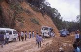
TANAH RUNTUH (LAND SLIDES) DI LEBUHRAYA UTARA-SELATAN
KEMALANGAN JALANRAYA KERAP BERLAKU DI LEBUHRAYA PANTAI TIMUR YANG BARU DIBUKA
KEMALANGAN JALANRAYA SEMEMANGNYA ADALAH KEJADIAN SETIAP HARI DI MANA-MANA
TEMPAT DI MALAYSIA! 

MENTERI KERJA RAYA - SAMY VELLU - MAKAN RASUAH BANYAK?
DISASTER AWARENESS IN MALAYSIA IS VERY LOW (EXCEPT HIGHWAY AND MAN-MADE DISASTERS)
AND SYSTEM OF `PRE-EMPTIVE' SAFETY-RESCUE-EVACUATION IS NON-EXISTENT!
Tanah runtuh di Cameron
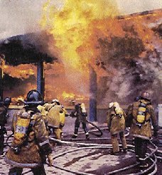
Kebakaran bangunan
Maklumbalas, Feedback
eMail pejuangmuda@yahoo.com
|
|
|

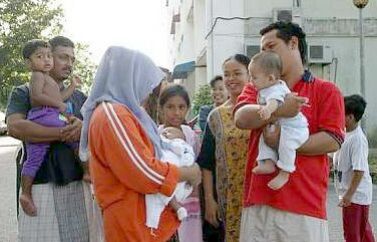
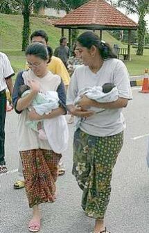
 PRECAUTION:Patients waiting outside the Selayang Hospital in Kuala Lumpur after tremors caused by the earthquake off the Sumatran coast were felt in the federal capital (around 9.00am).