 Marshal Vauban Website
Maintained by : Chris Jones of Altofts, Wakefield, U.K. © March 1998
The Fortress of Bellegarde - Roussillon:
This page created : 27 March 1998
The geography & history of Bellagarde
The Albéres mountains form the eastern end of the Pyrenees, the massive natural barrier that separates France & Spain. The pass known as the col de Perthus, mean altitude 270m, carries the road across these mountains, meandering between the Roc des Trois-Terms [1130m] to the east and the Roc de France [1450m] to the west.
It was via the col de Perthus that Hannibal passed the Pyrenees with his army, and his elephants, on his legendary march to Rome in the 3rd century before Christ. In later, more peaceful, times the road which followed the pass, the Via Domita, facilitated communication between the Roman provinces centred upon Narbonne and Tarragona.
In 1285 Pierre III King of Aragon, concerned with the threat posed by his northern neighbour Jacques II King of Majorca, had a fortress built high up on Mt Panissars [423m] where the the road finally emerges from the pass. This fortress, sited next to a precipice above the town of Le Perthus and the present day border crossing between France & Spain, was known as the "castrum de Bellaguarda". It was a relatively simple affair, a tower some 20m high with walls at most 1.5m thick. There was a small work protecting the entrance with a covered walkway some 30m in circumference around the base of the tower. Successive Lords who inhabited the place levied a toll on passing traffic, the proceeds going to the upkeep of the tower. However, in time, the place fell into disrepair.
With the Treaty of the Pyrenees in 1659 the border between France & Spain was re-drawn and Belleguarda ended up just inside France. The Priory of Pannisars which stood a short distance below the castrum in the Pannisars pass, and of which we will hear more later, was actually bisected by the new boundary.
It was at Bellaguarda that the French, under Douvrier, repelled a Spanish raid in 1667. The following year Jacques de Saint-Hillaire, Directeur des Fortifications for Roussillon, visited the site and extended it's defences. He added some redans, one of which was called the "redoute du precipice". Vauban made his first visit to the area the following year and no doubt considered how the place might be put in an even better state of defence, the position occupied by the fort being of such significance.
Bellegarde, to give it it's French title, was captured by the Spaniards in 1674. In 1675, still in possession of the place, they began planning a fort of their own which included proposals for detached works. However, work was not far advanced when the place fell back into French hands.
In 1675 the French engineer Dubruehl visited the place and, inspired by Vauban, considered plans for building a new fort. This was to have a pentagonal trace with an enlarged covered way extending, on one side, right up to the edge of the precipice overlooking Le Perthus. On the "landward" side there would be a front with bastions.
However, it was not until 1678 that Vauban's plans for the new fortress of Bellegarde were approved. As with all his proposals he had to submit plans either to Louvois or Colbert, the King's chief ministers. In this instance it will have been the War Minister Louvois, who had responsibility for the newly acquired territory of Roussillon, who will have given approval to proceed.
While Vauban will have conceived and finalised plans for Fort
Bellegarde, demolition of the old tower and the building of the
new work will have been overseen locally by Roussillon's own directeur
des fortifications, one Gabriel de La Motte-La Myre.
He had succeeded Saint-Hillaire to the post in 1678. However,
it was Vauban who solved the problem of a lack of sand for the
construction work. At his instigation suitable stones were hauled
up from the ruined Pannisars Priory and these were ground down
to make what sand was required!
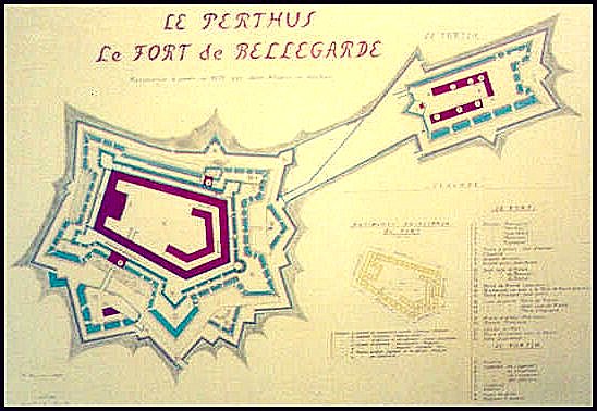
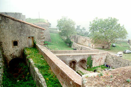
The fortress was built to a concentric pentagonal trace. It had
a strongly defended counterscarp - the covered way is approximately
1 km in length. The main enceinte had five powerful bastions.
Standing within but also surmounting this first curtain was a
second wall with five more bastions. These each sit
upon one of the bastions of the first trace, rather like a series
of linked cavaliers. Within this second wall was a third
continuous line of defence presented by the rear walls of the
buildings standing at the centre of the fortress. Here there was
barracks accommodation for the garrison and it's officers [some
600 men all told], a chapel, hospital, mill, bakery, and kitchens.
The officers were housed in a free standing block within the centre
of the fortress and facing the chapel.
The chapel was a considerable affair, as can be seen from the image above. It's interior is 11.2m wide
and some 12.5m high, although in the 19th century it's height
was diminished by the insertion of another floor. To the left of the chapel [see image above] is the opening into the fort's interior of the passageway leading from the fortress gates.
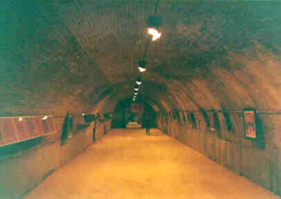
The fortresses main powder magazines were housed deep within it's bastions
in ventilated chambers. But there were also expense magazines located in the brick built buildings of the third line of defence. The image below shows one of these brick vaulted magazines. This one is located in the building behind the chapel.
One of the bastions in the second line of defence merits special attention since it follows a rounded trace rather than being the usual four-sided affair. The reason for this is far from clear, perhaps the intention was to emulate the shape of the former castrum's main tower? Less enigmatic is the huge hole at the base of this construction. A placard tells visitors the hole was blasted open by the Germans in the course of their occupation during WWII!
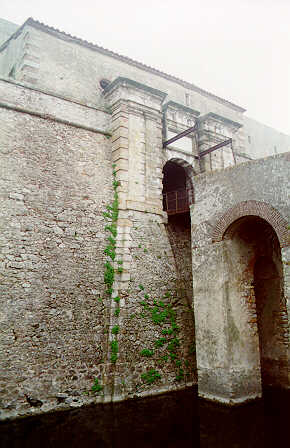 The only entrance to the fort, the Porte de France, was
protected by a powerful demi-lune [ravelin], one of three defending the curtain walls between bastions, and was accessed across a vaulted causeway
and finally a drawbridge [see image above]. The present drawbridge [see image right] is said to
date from the second half of the 19th century.
From the main gate one passes through the three layers of the fort's defences via a steep
ramp which opens onto the Place d'Armes, a
vast rectangular court yard around which most of the fort's buildings
are ranged.
The only entrance to the fort, the Porte de France, was
protected by a powerful demi-lune [ravelin], one of three defending the curtain walls between bastions, and was accessed across a vaulted causeway
and finally a drawbridge [see image above]. The present drawbridge [see image right] is said to
date from the second half of the 19th century.
From the main gate one passes through the three layers of the fort's defences via a steep
ramp which opens onto the Place d'Armes, a
vast rectangular court yard around which most of the fort's buildings
are ranged.
Within the bastion immediately to the right of the Porte de France is Bellegarde's immense well [I refer to the bastion which can be seen beyond the causeway in the image above, and which stands to the right of the gate as seen here in the image on the right]. The well is 6m across and 62m deep. It was completed in 1698 but only after Vauban had earlier ordered digging to stop, in 1686, because no water had yet been found. Vauban was in any event satisfied the fort's six rainwater-fed cisterns held enough to sustain a protracted siege.
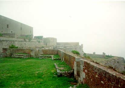
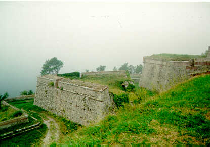
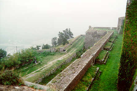
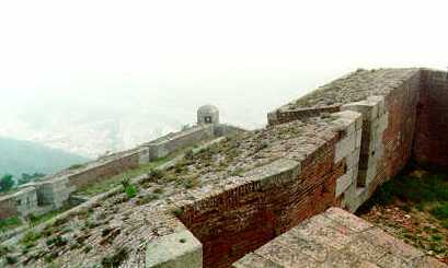
One of the most striking features of Bellegarde for visitors is
the front overlooked by the Panoramic Terrace. This is the
name given to the upper platform adjacent to the precipice overlooking
Le Perthus. Here the three succesive layers of fortress walls are
compressed closely together, allowing the defenders to develop
overwhelming musket fire against any enemy bold enough to attempt
to scale the precipice. The three-tier effect [four if you include the covered way] can be appreciated from the series of images appearing below here ...
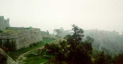
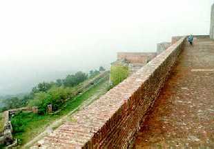 The Panoramic terrace. Left is covered way.
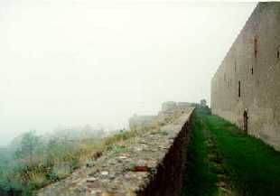 Below the terrace.
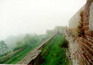 Lower still. Left is covered way.
From the Panoramic Terrace the views are spectacular
[even on a misty day!]. As Vauban himself remarked during a visit
in 1679 ...
"Nothing overlooks this place and, from it's ramparts, you can see the plains of Ampourdan and Roussillon equally well."
Beyond the main walls of the fort were three smaller works. These
were the two small redoubts of Pannisars & Perthus and an outlying fort
sited some 150m from Fort Bellegarde, in the direction of the frontier with Spain, and which was connected
via a covered way. This little fort [today completely ruined and
inaccessible, it is just visible in the middle background of the second & third of the three images above] was rectangular in shape and enclosed 22 small one
roomed buildings to house it's garrison. There was also a powder
magazine and a small chapel.
Bellegarde sees action
A Spanish force under General Ricardo invaded the upper Vallespir in the mid April of 1793. They occupied Prats de Mollo on 25 May and took neighbouring Fort Lagarde on 5 June. At the same time a separate column had captured Fort Baines on 6 June, after a spirited defence by it's garrison, and then moved on and took Bellegarde on 25 June 1793.
Later that year the French General Dagobert defeated the Spaniards at the Col de la Perche [28 August]; and later still at Puigcerda & Olete. This put the French in a position whereby they could set about recapturing lost possessions.
The following year, 1794, General Dugommier as Commander in Chief of France's army of the Pyrénées Orientales arrived before Bellegarde and set about retaking the place. This was achieved after a thirty four day siege, the place capitulating on 17 September 1794. Henceforth Bellegarde remained in French hands.
When Dugommier was killed by a mortar bomb at Figueras on 17 November 1794 it was to Bellegarde that his body was brought. And here he was buried until his body was later removed to Perpignan to be laid to rest next to his brother in arms General Dagobert. A monument to Dugommier stands today on the ramparts at Bellegarde.