|
|
|
Weather Links:
|
| Cirrostratus | Altostratus | Cumulus |
 |
 |
 |
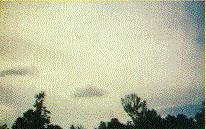
Cirrostratus is a filmy layer of milky-white ice crystal cloud normally covering the entire sky. The cloud can sometimes be 5,000 - 10,000 feet in thickness.
Base elevation:20,000-25,000 feet Top elevation: 30,000-40,000 feet |
Altostratus is a layer of gray water droplet cloud of uniform thickness. The sun can be seen as a difuse image. As time passes, this cloud often lowers and thickens to become nimbostatus with rain. Base elevation: 12,000-15,000 feet Top elevation: 15,000-20,000 feet |
Cumulus are flattish-based heaps or mounds of cloud with rounded tops well separated from each other.
Base elevation: 2,000-3,000 feet Top elevation: 4,000-6000 feet |
| Cirrus | Altocumulus | Cirrocumulus |
 |
 |
 |
Cirrus is a high level ice crystal cloud appearing in many forms, often as streams of snowflakes that evaporate in the lower warmer air. |
Altocumulus is a high layer of lumpy cloud elements. Lumps show the presence of rising air; thin regions show descending air. Sometimes it is described as a buttermilk sky.
Base elevation: 12,000-15,000 feet Top elevation: 15,000-20,000 feet |
Cirrocumulus is still higher water droplet cloud with smaller cloud elements resembling scales on the back of a fish, thus the term mackeral sky. Base elevation: 15,000-25,000 feet Top elevation: 20,000-30,000 feet |
| Cumulonimbus | Nimbostratus | Stratocumulus |
 |
 |
 |
Cumulonimbus is the most advanced stage of the cumulus family. The top is composed of ice crystals. It is no longer sharp edged, but fuzzy. The top sometimes takes the shape of an anvil. Heavy rain showers, hail, lightning and thunder, and tornados are possible in this savage cloud. Base elevation: 3,000-5,000 feet Top elevation: 30,000-50,000 feet |
Nimbostratus is a gray cloud mass from which widespread and continuous rain or snow falls. The cloud is associated with a warm front storm system. Base elevation: 1,000-2000 feet Top elevation: 10,000-15,000 feet |
Stratocumulus is a low layer of grayish cloud showing lumpy thick/thin regions. It is a very common cloud type. At one time the cumulus activity may prevail; at another, the stratus form may prevail. Base elevation: 3,000-5,000 feet Top elevation: 5,000-7,000 feet |