![]()
![]()
|
Bay Area |
Hiking Page |
County Parks |
Feedback |
Trails - Part 2
![]()
|
Rainbows & Waterfalls 2000
|
Trails on this
page:
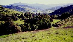
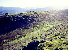
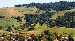
(Go to Trails - Part 1 for the rest of the park traiils) The Mine Trail is a long trail that intersects several other trails in the park. It begins above the old Buck Norred Ranch. The ranch is past a gate on Brockenhurst Drive, off Heaton Moor Drive. There is a neighborhood entrance at Brockenhurst Drive. Only authorized vehicles are allowed to drive in, but hikers, bikers, and equestrians can enter to reach the Mine Trail. The old ranch buildings are closed to the public. The Santa Clara County Parks Mounted Ranger Unit is now housed in this area, but is not open to the public. The Coyote-Alamitos Canal, which provided unofficial access from the south, is now fenced off and posted. (Note that the Coyote-Alamitos Canal running behind the houses west of Brockenhurst Drive is owned by the homeowners below it, so it is private property. This section of the canal is fenced off and posted, and the homeowners do not take kindly to strangers walking through what is technically their backyards.) At the bottom of the Mine Trail is a sign warning of mountain lions. The trail begins as a steep asphalt road. While this part of the trail does not get muddy in the rainy season, the wet asphalt can be slippery. A short distance from the trailhead is the start of the new Norred Trail, which branches off to the right. The trail passes by horse paddocks, though you're more likely to see deer here than horses. The trail runs below and parallel to Bernal Road. The Hidden Springs Trail crossing is halfway up Bernal Road and leads down to the Mine Trail. From there, the Mine Trail continues up the hill, as a wide dirt road. This section has steep and flat sections, with some parts shaded by oak trees. After .4 miles from the Hidden Springs Trail junction, it hits the start of the Bernal Hill Loop Trail, which branches off to the right. It levels out and follows the hill above Bernal Road for another .15 miles. Deer are frequently seen on the hill above the trail in the evening. The trail drops down and crosses Bernal Road and the Pueblo Trail near the upper parking lot. It then goes over and drops down Trench Hill in the middle of the park. This hill is covered with green grass and wildflowers in the spring. It has a trench in the middle, hence the name. After .33 miles, the Mine Trail meets the Stile Ranch Trail, which branches off to the right. From here, the Mine Trail is part of the Bay Area Ridge Trail. The Mine Trail follows along the base of the hill to the left and climbs up it. At the top of the hill is a lovely cluster of oak trees and rocks. The Mine Trail then takes a long, steep drop down to meet the Fortini Trail after .2 miles. It then turns north to head back into the heart of the park, crossing the Big Oak Trail after .25 miles. After another .1 miles, the trail comes back into the developed heart of the park, reaching the end of the parking lot and horse corral. The trail around here can be muddy in the wet months. The trail continues on above the developed area. It runs above the picnic area for another .34 miles and ends at the Hidden Springs Trail, which can be taken to complete the loop.
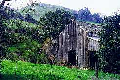
The Fortini Trail is one of two trails (the Stile Ranch is the other) that connect the park with the floor of the Almaden Valley. It's the flatter and easier of the two trails. It starts out as a wide farm road at a junction with the Mine Trail. For .35 miles, it's a straight, fast drop down towards the Almaden Valley. The trail parallels a small creek that drains the marsh by the Pueblo Area. There's a small dam on the creek here. The trail hooks to the right and crosses over a tiny creek, requiring an easy fording. The farm road then branches to the left, leading to the Rosetto Ranch, which is now a part of the park. A park employee lives in the house, which is not open to the public. The trail runs to the right. It continues on for another .5 miles as a narrow rocky path as it rounds a hill. It goes past the remains of a tree-shaded pool and picnic area that used to be a resort, called the Club 14E, which closed in the 1970's. This property is part of the park, but is not open to the public. The trail gets more rocky as it parallels private Fortini Road along a grassy hillside. The trail eventually hits the entrance to the Stile Ranch Trail in the Almaden Valley.
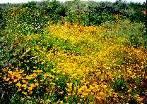
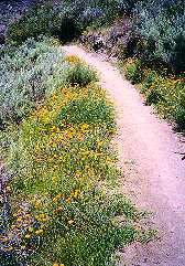
The 1.4-mile Stile Ranch Trail
is
an awesome trail. It has some of the best wildflower-viewing in the
park
and provides great views of both the Almaden Valley and the hills above
Blossom Valley. It runs through an easement provided by IBM, on a hill
just below the forest-green buildings of IBM's Almaden Research Center.
Some of the researchers at the center have created some excellent Web
pages on the wildlife habitats in the area, with beautiful
wildflower photographs. The trail was built by volunteers from IBM
and the community. The best way to take the trail is to start from its
entrance in the southern Almaden Valley, at the intersection of Fortini
Road and San Vicente Avenue. Fortini Road can be reached from McKean
Road.
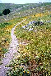
The trail zig-zags up a steep rocky hillside, that in the springtime
becomes
a wildflower-covered rock garden, bursting with color. Glowing orange
poppies
line the trail. As the trail winds higher, more and more of the rural
parts
of the Almaden Valley come into view, with the hills of Calero and
Almaden
Quicksilver Parks and the Sierra Azuls in the background. The trail
passes
through an ancient stone wall that runs through much of the park. The
trail
crests one hill, with views of the eastern part of the park, then drops
steeply down into a U-shaped valley. It crosses over a bridge, then
climbs
steeply up the other side of the valley, crests another rocky hill and
drops again into another U-shaped valley. The trail runs over another
bridge,
then follows the opposite side of the valley to the right, eventually
ending
at the Mine Trail. Using the Mine Trail and Fortini
Trail, it's possible to make a loop trip of the Stile
Ranch
Trail.
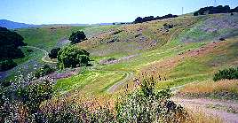
An old dirt farm road, the Calero Creek Trail, leads west from the head of the Stile and Fortini trails at the end of San Vicente Avenue. It runs along the base of the hills behind some farms, then turns left. It dips down to cross over the usually-dry concrete channel of Santa Teresa Creek. It continues straight, then turns right just before Calero Creek. It follows along a narrow corridor between Calero Creek and an orchard on IBM property. The dirt trail ends at Harry Road. On the other side of Harry Road and on the other side of the creek, the paved Calero Creek Trail begins. The Calero Creek Trail joins up with the Los Alamitos Creek Trail, which ends up at Almaden Lake and continues on as the Guadalupe River Trail. It's possible to make a bicycle loop trip between the Blossom Valley and Almaden Valley, starting at Bernal Road, to the Pueblo Day Use Area, the Mine Trail, the Stile Ranch or the Fortini Trail to the Almaden Valley, the Calero Creek and Los Alamitos Creek Trail to the head of the Almaden Valley, then take surface streets along the hills back to Bernal Road. Los Alamitos Creek joins Guadalupe Creek just north of Almaden Lake, forming the Guadalupe River. The Guadalupe River runs through downtown San Jose, meets up with Los Gatos Creek, flows into the Alviso Slough, and enters the Bay at Alviso. The Alamitos Creek Trail will someday be extended to trails along the Guadalupe River and Guadalupe Creek upstream to Almaden Quicksilver. It will then not only be possible to take the trail to the Bay at Alviso, but it will provide access to the Bay-circling San Francisco Bay Trail. The Bay Trail is a proposed 400-mile network of trails encircling the Bay along its shores. So far, over 173 miles of the trail are open to the public, with more being added every year. Thus, it will someday be possible to hop on a trail at Santa Teresa Park and ride all the way around the Bay.
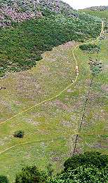
The .6-mile Joice Trail starts at what is called the Bernal-Gulnac-Joice Ranch at the corner of Camino Verde Drive and Manila Drive at the northwestern corner of the park. The main house there is called the Bernal-Gulnac-Joice House or the Bernal-Joice House. The ranch was first called Rancho Santa Teresa, then Santa Teresa Ranch, Bernal Ranch, and then Santa Teresa Stables. This part of the park has been developed into an interpretive center that offers tours to classes on weekdays and is open to the public on weekends. This part of the park was dedicated in June 2002. The trail is the service road that starts behind the barn. It's mostly along steep grassy and rocky hills with little shade, so it's best taken in cool weather, in the morning, or late afternoon. It runs almost straight up the hill in a very steep initial climb, past a vine-covered ravine. Partway up the hill, the new Norred Trail branches off to the left. The Joice Trail continues up the steep slope, levels off a bit, then sweeps around a valley and up around a hill, with great unobstructed views of the Blossom Valley/Santa Teresa area all the way. A wide variety of springtime wildflowers line the trail. The trail levels off and curves to the left. At this point, an unmarked trail branches off to the right near the route of huge high-tension power towers. This path is the remains of a PG&E service road for the power towers. It eventually dead ends near the northern boundary of the park above Cottle Road. Meanwhile, the Joice Trail continues south and ends at the junction with the Bernal Hill Loop Trail.
At the top end of the Joice Trail, the Bernal Hill Loop Trail continues on, and the loopback branches off to the right. Taking the right branch, the trail climbs higher up the bare, rocky hill, then levels off, curving to the left to head south along the hillside. This part of the trail is mostly level, with some ups and downs. The hilltops block the view of the city, so it seems like you're way out in the country. The trail here tends to get a bit overgrown with weeds in late spring until they clear it. After .4 miles, the trail hits a junction leading up to the Vista Loop Trail. Meanwhile, the main trail drops down the hill for .2 miles in a very steep path surfaced with soft, loose dirt. At the bottom, it hits a junction. This trail junction can get muddy in the rainy season and overgrown with weeds in the spring. If you take the trail to the left, it climbs up around the hillside and loops back for .7 miles to the Joice Trail, with great views of the park, the Norred Ranch site, and the neighborhood below. This section of the trail has some of the densest wildflower displays in the park. Back at the trail junction, if you take the fork to the right, the trail rises up, passes under the shade of oak trees, then drops down to join the Mine Trail near Bernal Road.
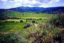
At the high point of the Bernal Hill
Loop Trail,
a short connector leads up the hill to a gate. The trail climbs higher,
revealing views of the green fields of the southern Almaden Valley and
the blue waters of Calero Reservoir. This is the .55-mile Vista
Loop
Trail. It loops around near the top of the hill, passes by
bushes
that shelter deer and wild turkey. A fence along here near the summit
marks
the boundary of the park. Beyond this is private land, including IBM
property.
The highest point in this area, which is on private property, is at
1026
feet, nearly as high as Coyote Peak. The trail drops down steeply
through
a dense, shady oak forest. You get a stunning view of the Santa Teresa
area as you emerge from the tunnel of the oak forest. You can see most
of the rest of the Santa Teresa Hills to the northwest, which are
unfortunately
not parkland. The trail turns right and follows the fenceline along the
hillside back to the entry gate, with great views all the way.
The Rocky Ridge Trail
does not go up the real Rocky Ridge, but it goes up A rocky ridge. It
branches
off the Mine Trail just west of the paved part of the park, then enters
Big Oak Valley, which lies between Rocky Ridge and the lower slopes of
Coyote Peak. The trail passes through an old fence and reaches a wooden
foot bridge over the creek in the valley. Beyond the bridge, the trail
ascends
a rocky ridge. After it crosses the creek, it goes deeper into the
oak-forested
valley, then switches back to start climbing along the south wall of
the
Coyote Peak ridgeline. Rocky Ridge and the Fortini, Mine, and Stile
Ranch
Trails are visible from the slopes. The trail continues to climb the
rock-strewn
slopes, heading closer to the Almaden Valley. Soon the green fields of
the southern Almaden Valley come into view. The trail begins to climb
gently
straight up the hill. It passes through a gap in an ancient rock wall
and
switches back towards Coyote Peak. Springtime wildflowers line this
route.
More of the Santa Teresa Hills and the Almaden Valley come into
view.
It passes just above the Coyote Peak Trail. Undeveloped wooded private
hillside land to the south becomes visible. The trail continues on,
following
along the hillsides, with increasing views of the Santa Teresa area and
South San Jose. The trail eventually turns right to meet the Coyote
Peak
Trail near the abandoned microwave station.
The Santa Teresa Springs area is open to public access and is part of the Santa Teresa Historical Area. The springs used to be fenced-off and hidden behind brush, though local neighbors knew of its existence. The constant flow of water into a street drain, even in the dry summer, revealed the existence of the water source. The springs area is possibly the most historically significant site in the park. It is linked to the origin of the park's name. The springs are natural, and existed during the time the Ohlone Indians occupied the area, perhaps for 3000 years or longer. The Indians had a legend about a mysterious black-robed woman who created the springs and thus saved a village from disease. Many years later, in 1776, an expedition led by Juan Bautista de Anza came to the San Francisco Bay Area with the intent of establishing a Spanish colony here. They passed through the Santa Clara Valley on their way up the Peninsula. 200 settlers were part of the expedition, including 13 year-old Jose Joaquin Bernal. Joaquin went with the party to Yerba Buena (now San Francisco) and later became a soldier in the Presidio. In the 1820's, he retired and settled in the part of the Santa Clara Valley around Santa Teresa Springs. Joaquin heard of the legend and attributed it to the appearance of Saint Teresa of Avila, patron saint of healing. He gave the name Santa Teresa to the springs and his 9,647-acre ranch. The entrance to the springs is along Manila Drive, just south of the Joice Bernal Rancho. A sloping path leads to a wooden observation platform built around the springs' pond. A small stone font surrounds the outlet of the waters of the springs. Next to it is a rock shelf that once held a glass-enclosed statue of St. Teresa. On the rock next to the shelf is inscribed, "Made by P. A. Bernal Oct. 1928. This was Pedro Bernal, the great-grandson of Joaquin. The spring waters flow into a grate-covered cistern before draining into the circular pond. The pond is rimmed by vines and shaded by huge oak trees. The pond is artificial. It was used for irrigation and as a swimming pool. It was the first swimming pool in Santa Clara County. (No swimming allowed now.) The newly-built boardwalk runs around the edges of the pond and up to the spring. The wooden rails prevent direct access to the pond. If you look carefully into the dark waters, you may spot some fish and turtles. (No fishing allowed.) Waters from the springs were used to supply the nearby ranch. At one time, the water was bottled and sold. The spring waters have continued to flow even during the driest drought years. During the hottest days of late summer, when the surrounding hills and creeks are bone dry, you can still see a steady stream of water overflowing from the pond. Many legends and stories are associated with the pond and its
surroundings.
One local legend has it that one of the members of the Bernal family,
named
Dottie, was swimming in the pond when a giant hand reached up and
pulled
her underwater, where she drowned. Because of this, the pond is known
locally
as Dottie's pond. Nearby is an Indian burial ground where ancient
skeletons
have been discovered. Neighbors in the area have reported strange
happenings
and ghostly sightings. Night janitors at nearby Bernal Intermediate
school
have also reported seeing apparitions. Below the pond is an old
concrete
trough. In this area was once a vat that was used by a French
saddlemaker,
Changara, to tan hides. Legend has it that Changara buried his earnings
nearby. He was killed by bandits before revealing the location of his
cache,
which has never been found. Also near here is an empty lot a block west
of the corner of Curie and San Ignacio. An historical marker here
signifies
that this is the Bear Tree Lot, where the Bernal famliy once held
bull-and-bear
fights, which were one of the forms of entertainment during the annual
rodeos held here. The animals were tied to a large oak tree which still
survives in the lot.
The Norred Trail is
a new trail, opened in May, 2007. It was built in response to
complaints by neighbors in the Buck Norred
Ranch area that hikers were illegally trespassing on their private
property by using the Coyote-Alamitos Canal behind their houses as a
trail. It provided a flat, easy trail between the Buck Norred Ranch and
the Bernal-Gulnac-Joice Ranch. To discourage use of the canal, but
still provide a trail between these two parts of the park, the Norred
Trail was built. It starts partway up the hill from the Joice Trail. It then runs nearly level along the
side of the hill. The trail provides great views of the
Bernal-Gulnac-Joice Ranch, Santa Teresa Spring, the city of San Jose's
Albertson Parkway, the Bear Tree Lot, the Pyzak Ranch, and the Bonetti
Ranch. There are plans being formulated to develop this area into an
interpretive center and staging area. Once it becomes developed, there
may be a connector trail up to the Norred Trail. Right above Bernal
School, the trail makes a sharp right turn. The Coyote-Alamitos Canal,
the Buck Norred Ranch, and the houses below it can be seen. There are
more trees and bushes in this area, as well as large rocks. It then
passes by several old ranch buildings, a barn, a covered pavilion, and
horse stalls. It then follows a gravel service road and drops down the
hill to the back of the Mounted Ranger Unit. Access to the Mounted
Ranger Unit is restricted. The trail continues as a narrower dirt road
along the side of the hill overlooking the old barn, stables, and
office of the Mounted Ranger Unit. The trail ends near the bottom of
the Mine Trail.
The Bay Area Ridge Trail is a dream in progress. It's a proposed network of trails that will someday provide a continuous 400-mile long trail system along the ridgetops circling the entire Bay Area. It will connect ridges in 9 counties and 100 communities. It promises to be one of the greatest urban trail systems in the world. Currently, 218 miles of trails are part of the system. Santa Teresa Park has the honor of being part of that trail system now. The Ridge Trail segment that runs through Santa Teresa Park starts at the Los Alamitos Creek Trail at the intersection of Harry Road and McKean Road. It follows the trail down Los Alamitos Creek to its confluence with Calero Creek. It turns right and follows the trail up Calero Creek. After crossing over Harry Road, it follows the Calero Creek Trail to the entrance of Santa Teresa Park at the Stile Ranch Trail. It takes the Stile Ranch Trail to the Mine Trail to the Pueblo Trail, to the Hidden Springs Trail, to the Coyote Peak Trail, and ends at Coyote Peak. The next nearest completed segment of the Ridge Trail is along the Coyote Creek Trail. You can catch this trail in the middle by going down Bernal Road to Silicon Valley Blvd. You can catch the trail just before the road crosses Coyote Creek. This trail will eventually connect to proposed Ridge Trail segments through the Diablo Range. Proposed nearby trail segments will run through Calero Reservoir County Park, Almaden Quicksilver County Park, Sierra Azul Open Space Preserve, Lexington Reservoir Recreation Area, St. Joseph Hill Open Space Preserve, to the completed section through the Santa Cruz Mountains, starting at Sanborn Skyline County Park. Created 9/20/99, update 11/22/07 by Ronald Horii |