Mountain photos from Stara planina,
Bulgaria
Stara planina mountain (Balkan) is located in the middle of the country. It's long ridge is
from West border of Bulgaria to the Black sea to the East. Highest peak is Botev
peak (2376 meters above sea level, a.s.l.) and is atmost in geographical
center of Bulgaria. One can see more than half of territory of the country. Another
significant peaks in this mountain are Zhultec, Goljam Kupen
(2169m a.s.l.) Ambarica, Vezen (2198 m a.s.l). In the
very west on the ridge are Kom (2016m a.s.l), Midzhur.
Many waterfalls are nearby Botev peak - (Rajsko pruskalo, Vidimsko pruskalo, Dzhendemsko
pruskalo).
Stara planina is the backbone of my country.
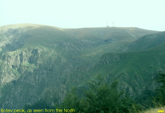
 Botev peak as seen from North. Reach of rocks, grass, waters. High 2376
meters. When on the summit,
Botev peak as seen from North. Reach of rocks, grass, waters. High 2376
meters. When on the summit,
 one feels like he flies in Heaven. This is because the summit is a wide level meadow, and the near neighbour peaks are obscured. (140k,
108k).
one feels like he flies in Heaven. This is because the summit is a wide level meadow, and the near neighbour peaks are obscured. (140k,
108k). Rajsko pruskalo. The highest waterfall in Bulgaria - 124 m. Located on South slope of Botev peak. Next to the waterfall is situated Raj hostel.
The name Raj (Paradize in English) speaks about the beauty of this place. (156k).
Rajsko pruskalo. The highest waterfall in Bulgaria - 124 m. Located on South slope of Botev peak. Next to the waterfall is situated Raj hostel.
The name Raj (Paradize in English) speaks about the beauty of this place. (156k).
|

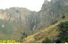
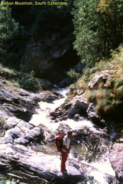
 Southern Dzhendem.
It is a beautifull and somewhat fearful canyon located in the South of Botev peak. Bjala reka
(White river) was created this narrow valley where is hard to find level
place for a single tent! Hence its name: Dzhendem is a Turkish word which means Hell.
The Dzhendem is as long as few kilometers (4 - 5) but one should spend about two days to go through it.
This waterfall is one of the many in the canyon. There is
Northern Dzhendem in the North of Botev. It is different from South one but is very impressive too. (118k ,148k)
Southern Dzhendem.
It is a beautifull and somewhat fearful canyon located in the South of Botev peak. Bjala reka
(White river) was created this narrow valley where is hard to find level
place for a single tent! Hence its name: Dzhendem is a Turkish word which means Hell.
The Dzhendem is as long as few kilometers (4 - 5) but one should spend about two days to go through it.
This waterfall is one of the many in the canyon. There is
Northern Dzhendem in the North of Botev. It is different from South one but is very impressive too. (118k ,148k) |
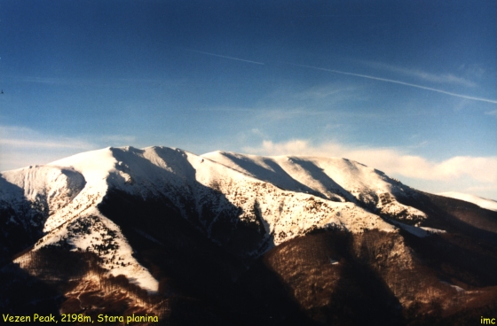
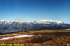 This is a view of Stara planina
from its southern neighbour Sredna gora. The spring has
come in the lowlands but the snow still stays on the ridge. The peak on
the right of the picture is Vezen (Vezhen) 2198 meters.
It is the highest one in this part of the mountain - Tetevenska
Stara planina. (154k).
This is a view of Stara planina
from its southern neighbour Sredna gora. The spring has
come in the lowlands but the snow still stays on the ridge. The peak on
the right of the picture is Vezen (Vezhen) 2198 meters.
It is the highest one in this part of the mountain - Tetevenska
Stara planina. (154k). |

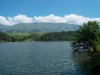 Here is two pictures where Stara planina can be viewed again but at
the back plane. The lake in the forefront is an excellent place for picnic
or fishing.
Here is two pictures where Stara planina can be viewed again but at
the back plane. The lake in the forefront is an excellent place for picnic
or fishing. |
 The Eho hostel region.
This mountain house
is built 5 meters below the mountain ridge (113k). It is like a bird on the
high rock. The place is known to have exceptional views to all directions. The Eho hostel region.
This mountain house
is built 5 meters below the mountain ridge (113k). It is like a bird on the
high rock. The place is known to have exceptional views to all directions.
 Second picture shows the
snowy look of Jumruka peak, 1818m (36k). It was made at 02 January, 2000.There was so much
snow in the mountain so it was our real Y2K problem, the computers did
not suffer. In fact, there is no computers in the hostel ;) Second picture shows the
snowy look of Jumruka peak, 1818m (36k). It was made at 02 January, 2000.There was so much
snow in the mountain so it was our real Y2K problem, the computers did
not suffer. In fact, there is no computers in the hostel ;)
 Next
photo shows the same peak but in summertime (145k). One can reach it from the hostel in 20-30 minutes or less. It is
green summertime. Its slopes are rich of blueberries. A metal rope is mounted at its East
edge to help climbing in wintertime. And at last a winter view to Vezen peak in the right. (149k) Next
photo shows the same peak but in summertime (145k). One can reach it from the hostel in 20-30 minutes or less. It is
green summertime. Its slopes are rich of blueberries. A metal rope is mounted at its East
edge to help climbing in wintertime. And at last a winter view to Vezen peak in the right. (149k)
|
|
 This
picture shows the North view of Svishti plaz
peak (1888m). This peak is situated in Central part of
the mountain, near Etropole and Zlatica towns. The point of view is next
to Jamna village (Yamna). It was late spring and all was green. (81k) This
picture shows the North view of Svishti plaz
peak (1888m). This peak is situated in Central part of
the mountain, near Etropole and Zlatica towns. The point of view is next
to Jamna village (Yamna). It was late spring and all was green. (81k) |
|
|
|
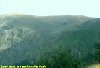
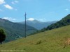
 The
picture shows a panorama to Zvezdec peak
(1655m) in Western Stara planina. The Hemus highway is seen at the
front of the picture. The
picture shows a panorama to Zvezdec peak
(1655m) in Western Stara planina. The Hemus highway is seen at the
front of the picture. |

 Beklemeto. This is a pass in Stara planina, between Troyan town from North and
Karnare
village from South. The mountain is very nice here. It is the right place for
mountain biking and paragliding. You can leave your car at Beklemeto mountain resort and go to
the ridge with your bike. The pleasure is guaranteed. The monument seen in
the left picture is devoted to the Russian soldiers, fallen in Russian-Turkish war 1877-1878 year.
Beklemeto. This is a pass in Stara planina, between Troyan town from North and
Karnare
village from South. The mountain is very nice here. It is the right place for
mountain biking and paragliding. You can leave your car at Beklemeto mountain resort and go to
the ridge with your bike. The pleasure is guaranteed. The monument seen in
the left picture is devoted to the Russian soldiers, fallen in Russian-Turkish war 1877-1878 year. |

 The
rocks of Belogradchik. A place rich of natural beauty and human history.
The greatest sculptor has used its tools - the water, wind and Sun - for
centuries to create these fantastic rocks. Almost each one was given a name by
our predecessors. And almost each one keeps an old legend from our past. The
fortress that the rocks hide is as ancient as Rome Empire. When entering
Bulgaria by Vidin ferry don't hurry to Sofia. Come here. You will not regret
for the time spent. The town of Belogradchik is near by E79
international route to Sofia and Athens.
More pictures from this nice place The
rocks of Belogradchik. A place rich of natural beauty and human history.
The greatest sculptor has used its tools - the water, wind and Sun - for
centuries to create these fantastic rocks. Almost each one was given a name by
our predecessors. And almost each one keeps an old legend from our past. The
fortress that the rocks hide is as ancient as Rome Empire. When entering
Bulgaria by Vidin ferry don't hurry to Sofia. Come here. You will not regret
for the time spent. The town of Belogradchik is near by E79
international route to Sofia and Athens.
More pictures from this nice place
 |
These pages are best viewed at 1024x768 display resolution.
The photos and texts in these pages may not be reproduced at
other sites and may not be used for
commercial purposes without author's permission.
See also: Rila, Pirin,
Back to mountain's home
 Botev peak as seen from North. Reach of rocks, grass, waters. High 2376
meters. When on the summit,
Botev peak as seen from North. Reach of rocks, grass, waters. High 2376
meters. When on the summit,
 one feels like he flies in Heaven. This is because the summit is a wide level meadow, and the near neighbour peaks are obscured. (140k,
108k).
one feels like he flies in Heaven. This is because the summit is a wide level meadow, and the near neighbour peaks are obscured. (140k,
108k). Rajsko pruskalo. The highest waterfall in Bulgaria - 124 m. Located on South slope of Botev peak. Next to the waterfall is situated Raj hostel.
The name Raj (Paradize in English) speaks about the beauty of this place. (156k).
Rajsko pruskalo. The highest waterfall in Bulgaria - 124 m. Located on South slope of Botev peak. Next to the waterfall is situated Raj hostel.
The name Raj (Paradize in English) speaks about the beauty of this place. (156k).
 Southern Dzhendem.
It is a beautifull and somewhat fearful canyon located in the South of Botev peak. Bjala reka
(White river) was created this narrow valley where is hard to find level
place for a single tent! Hence its name: Dzhendem is a Turkish word which means Hell.
The Dzhendem is as long as few kilometers (4 - 5) but one should spend about two days to go through it.
This waterfall is one of the many in the canyon. There is
Northern Dzhendem in the North of Botev. It is different from South one but is very impressive too. (118k ,148k)
Southern Dzhendem.
It is a beautifull and somewhat fearful canyon located in the South of Botev peak. Bjala reka
(White river) was created this narrow valley where is hard to find level
place for a single tent! Hence its name: Dzhendem is a Turkish word which means Hell.
The Dzhendem is as long as few kilometers (4 - 5) but one should spend about two days to go through it.
This waterfall is one of the many in the canyon. There is
Northern Dzhendem in the North of Botev. It is different from South one but is very impressive too. (118k ,148k) This is a view of Stara planina
from its southern neighbour Sredna gora. The spring has
come in the lowlands but the snow still stays on the ridge. The peak on
the right of the picture is Vezen (Vezhen) 2198 meters.
It is the highest one in this part of the mountain - Tetevenska
Stara planina. (154k).
This is a view of Stara planina
from its southern neighbour Sredna gora. The spring has
come in the lowlands but the snow still stays on the ridge. The peak on
the right of the picture is Vezen (Vezhen) 2198 meters.
It is the highest one in this part of the mountain - Tetevenska
Stara planina. (154k). 
 Here is two pictures where Stara planina can be viewed again but at
the back plane. The lake in the forefront is an excellent place for picnic
or fishing.
Here is two pictures where Stara planina can be viewed again but at
the back plane. The lake in the forefront is an excellent place for picnic
or fishing.
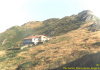
 The Eho hostel region.
This mountain house
is built 5 meters below the mountain ridge (113k). It is like a bird on the
high rock. The place is known to have exceptional views to all directions.
The Eho hostel region.
This mountain house
is built 5 meters below the mountain ridge (113k). It is like a bird on the
high rock. The place is known to have exceptional views to all directions.
 Second picture shows the
snowy look of Jumruka peak, 1818m (36k). It was made at 02 January, 2000.There was so much
snow in the mountain so it was our real Y2K problem, the computers did
not suffer. In fact, there is no computers in the hostel ;)
Second picture shows the
snowy look of Jumruka peak, 1818m (36k). It was made at 02 January, 2000.There was so much
snow in the mountain so it was our real Y2K problem, the computers did
not suffer. In fact, there is no computers in the hostel ;)
 Next
photo shows the same peak but in summertime (145k). One can reach it from the hostel in 20-30 minutes or less. It is
green summertime. Its slopes are rich of blueberries. A metal rope is mounted at its East
edge to help climbing in wintertime. And at last a winter view to Vezen peak in the right. (149k)
Next
photo shows the same peak but in summertime (145k). One can reach it from the hostel in 20-30 minutes or less. It is
green summertime. Its slopes are rich of blueberries. A metal rope is mounted at its East
edge to help climbing in wintertime. And at last a winter view to Vezen peak in the right. (149k)


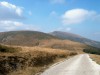
 Beklemeto. This is a pass in Stara planina, between Troyan town from North and
Karnare
village from South. The mountain is very nice here. It is the right place for
mountain biking and paragliding. You can leave your car at Beklemeto mountain resort and go to
the ridge with your bike. The pleasure is guaranteed. The monument seen in
the left picture is devoted to the Russian soldiers, fallen in Russian-Turkish war 1877-1878 year.
Beklemeto. This is a pass in Stara planina, between Troyan town from North and
Karnare
village from South. The mountain is very nice here. It is the right place for
mountain biking and paragliding. You can leave your car at Beklemeto mountain resort and go to
the ridge with your bike. The pleasure is guaranteed. The monument seen in
the left picture is devoted to the Russian soldiers, fallen in Russian-Turkish war 1877-1878 year.
 The
rocks of Belogradchik. A place rich of natural beauty and human history.
The greatest sculptor has used its tools - the water, wind and Sun - for
centuries to create these fantastic rocks. Almost each one was given a name by
our predecessors. And almost each one keeps an old legend from our past. The
fortress that the rocks hide is as ancient as Rome Empire. When entering
Bulgaria by Vidin ferry don't hurry to Sofia. Come here. You will not regret
for the time spent. The town of Belogradchik is near by E79
international route to Sofia and Athens.
More pictures from this nice place
The
rocks of Belogradchik. A place rich of natural beauty and human history.
The greatest sculptor has used its tools - the water, wind and Sun - for
centuries to create these fantastic rocks. Almost each one was given a name by
our predecessors. And almost each one keeps an old legend from our past. The
fortress that the rocks hide is as ancient as Rome Empire. When entering
Bulgaria by Vidin ferry don't hurry to Sofia. Come here. You will not regret
for the time spent. The town of Belogradchik is near by E79
international route to Sofia and Athens.
More pictures from this nice place