Mountain photos from Rila, Bulgaria
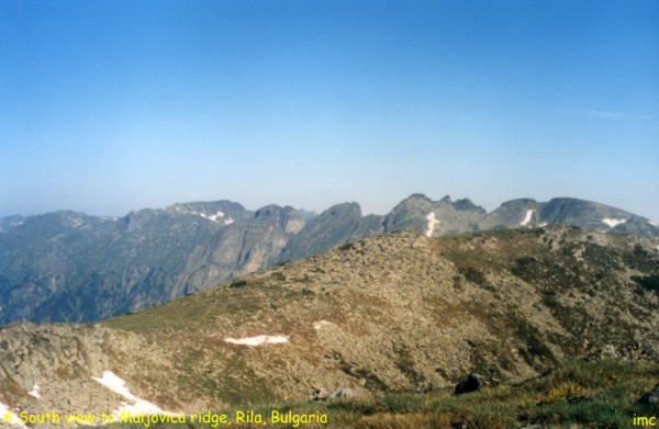
Rila is the highest mountain in Bulgaria and Balkan
peninsula. Most of high peaks are about 2500 - 2700 m a.s.l. Some of them have alpine look
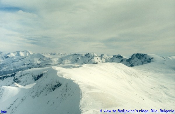
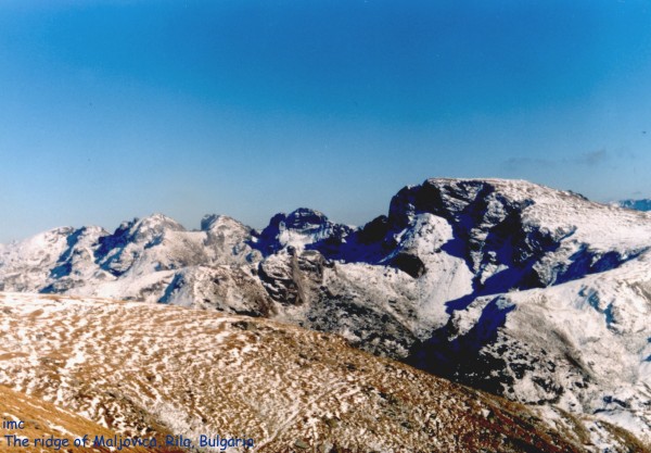
(Maljovica (2730) and its ridge, others are high-mountain meadows (mostly
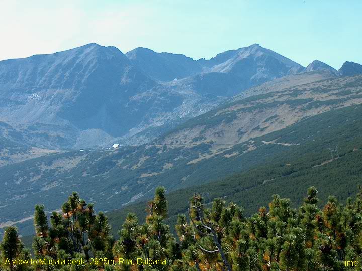
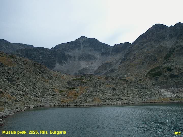
in Eastern Rila). Several peaks are higher - 2800 - 2900 m. Mussala peak
with its 2925.40m a.s.l is the highest point of the mountain. Little
Mussala (2902m) and Irechek (2852m) are next to it. The mountain
is divided to four main parts by deep glacier-made valleys. These are the valleys of Iskar
rivers, Rilska river, Mariza river. Another beautiful
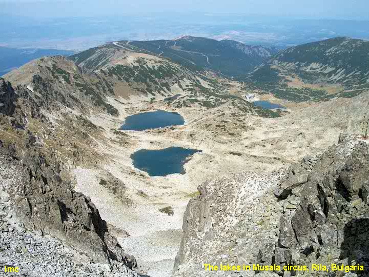
pieces of this mountain are its eyes - glacier lakes.
Rila is like a mother who
had grown her sons and feels safe for the future. They won't leave her.
|
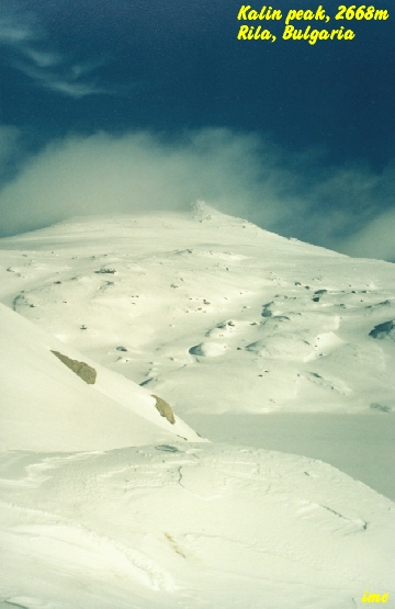
 Kalin peak
 (2668m).
Situated in Nord-west Rila. High 2668m. This photo was made at 1st of
January 1998 - a beautiful sunny day. One can see a part of Kalin lake in the down side of
the picture - frozen and covered with snow. The nord side of the peak is an vertical wall.
(36k). The right picture shows Kalin peak from North-East, but in the late autumn. (58k) (2668m).
Situated in Nord-west Rila. High 2668m. This photo was made at 1st of
January 1998 - a beautiful sunny day. One can see a part of Kalin lake in the down side of
the picture - frozen and covered with snow. The nord side of the peak is an vertical wall.
(36k). The right picture shows Kalin peak from North-East, but in the late autumn. (58k)
|
|
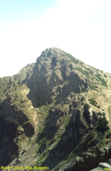
 Mechit peak, 2598m
(53k). Another member of Maljovica ridge. It is the
first high peak of this rocky chain. There are fantastic views to all directions: The Skakavci
ridge is seen to the East. Behind it, the Balkan's summit Mussala
is located. Middle Rila is to the South. One can see its high peaks - Pogledec,
Josifica, Kanarata and many others. A plenty of lakes
shine on the Sun rays. The deep valley of Beli Iskar
river (White Iskar) is below the peak. The rest of Maljovica ridge
continues to the West with Lopushky peak, Popova kapa, Golyam
Kupen an so on till to Maljovica. Another mountain, Vitosha,
can be seen to the North. It is located near by Bulgarian capital - Sofia.
Mechit peak, 2598m
(53k). Another member of Maljovica ridge. It is the
first high peak of this rocky chain. There are fantastic views to all directions: The Skakavci
ridge is seen to the East. Behind it, the Balkan's summit Mussala
is located. Middle Rila is to the South. One can see its high peaks - Pogledec,
Josifica, Kanarata and many others. A plenty of lakes
shine on the Sun rays. The deep valley of Beli Iskar
river (White Iskar) is below the peak. The rest of Maljovica ridge
continues to the West with Lopushky peak, Popova kapa, Golyam
Kupen an so on till to Maljovica. Another mountain, Vitosha,
can be seen to the North. It is located near by Bulgarian capital - Sofia.
|
|

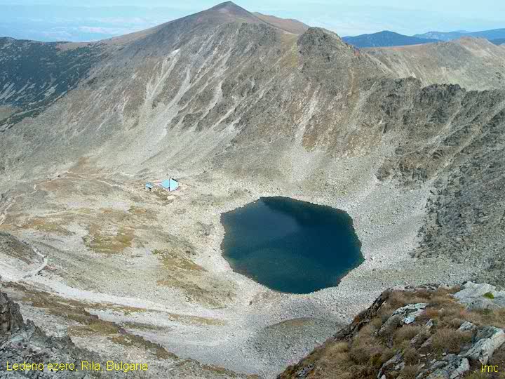
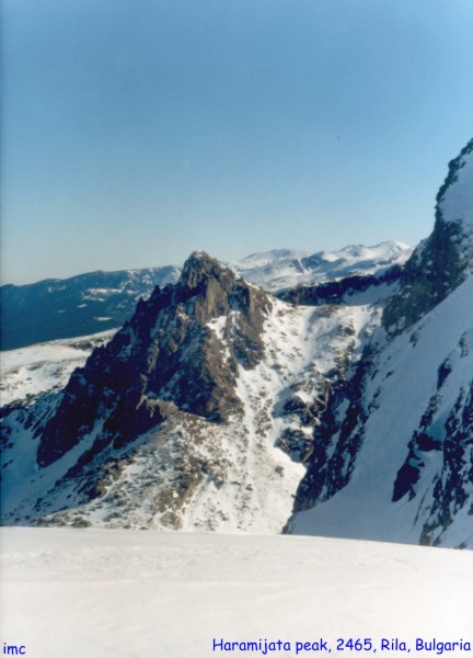
 The Seven lakes' circus. This rocky peak is located in Seven Lakes
region, North-West Rila. It's name is
Haramijata (Hajduta) and is as tall as 2465m. The highest peak of
Balkans, Mussala, is seen on the back plane. (55k). Next
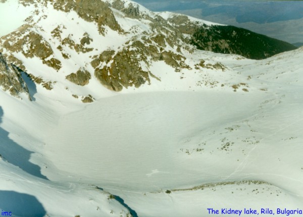
picture is of the Bubreka
(the Kidney) lake, one of the Seven Rila lakes. Now, in the
winter, it is covered with ice and snow. (62k).
The Seven lakes' circus. This rocky peak is located in Seven Lakes
region, North-West Rila. It's name is
Haramijata (Hajduta) and is as tall as 2465m. The highest peak of
Balkans, Mussala, is seen on the back plane. (55k). Next
picture is of the Bubreka
(the Kidney) lake, one of the Seven Rila lakes. Now, in the
winter, it is covered with ice and snow. (62k).
|
|
 Circus of Suha Vapa peak. Excellent place for camping in East Rila. A big lake, even meadows,
peak to climb on ... what more? The hostel Grunchar is near
by the lake. The curcus is situated at 2185m a.s.l. while
Suha Vapa peak (56k) is as
high as 2638m. One can climb on it directly from the lake (with some risk) or
go round on the West bank of the curcus. The second picture shows
Kovach peak (2640m) (44k). It
can be reached in an hour or more from Grunchar hostel.
The peak is rich with views to all directions, and it can be seen from almost
the whole mountain. Kovach in Bulgarian language means
smith in English. The name of the peak arises from the smith
workshops in its foots that were there in XIX century. The south-east slope is
a vertical wall.
Circus of Suha Vapa peak. Excellent place for camping in East Rila. A big lake, even meadows,
peak to climb on ... what more? The hostel Grunchar is near
by the lake. The curcus is situated at 2185m a.s.l. while
Suha Vapa peak (56k) is as
high as 2638m. One can climb on it directly from the lake (with some risk) or
go round on the West bank of the curcus. The second picture shows
Kovach peak (2640m) (44k). It
can be reached in an hour or more from Grunchar hostel.
The peak is rich with views to all directions, and it can be seen from almost
the whole mountain. Kovach in Bulgarian language means
smith in English. The name of the peak arises from the smith
workshops in its foots that were there in XIX century. The south-east slope is
a vertical wall.
|
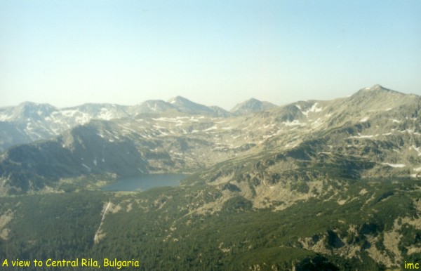
 Here are
several pictures of Central Rila. One can see its highest peaks -
from left to right Kanarata 2691m, Cherna poljana 2716m,
Aladja slap 2684m and Riletz 2713m. Here are
several pictures of Central Rila. One can see its highest peaks -
from left to right Kanarata 2691m, Cherna poljana 2716m,
Aladja slap 2684m and Riletz 2713m.
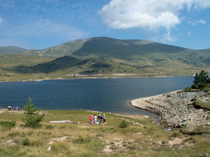
 It is the time of late spring - second
half of June and the snow drifts make the mountain to look so beautiful. The biggest lake
in Rila (and in all Bulgarian mountains as well) is in the front of the ridge. Its name is
Smradlivo ezero and is long about 900 meters (50k). The right
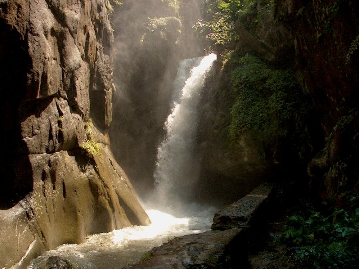
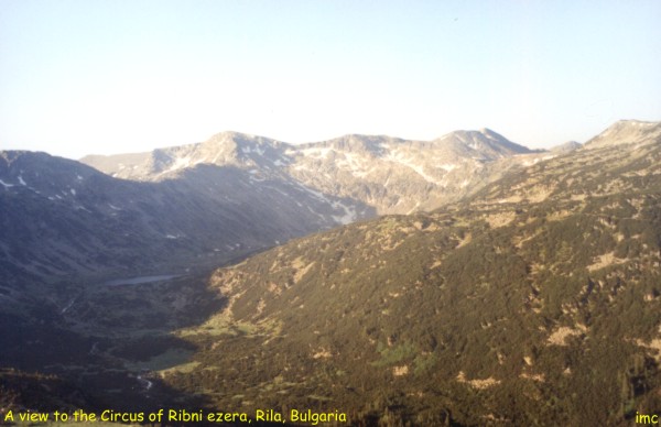
picture shows the
circus of Ribni ezera (Fish lakes) (51k). These are two big lakes,
situated in the upper end of the deep narrow valley of Rilska reka
(river). Kanarata and Yosifica (2697m) peaks stay at 400
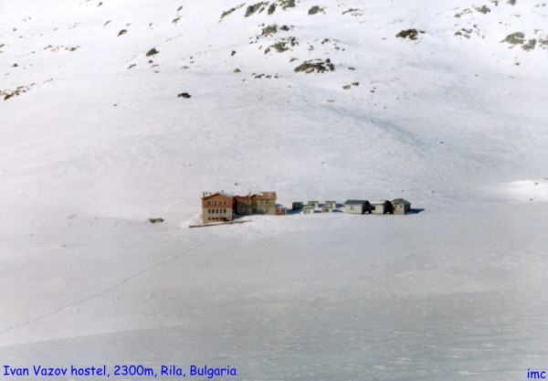
- 500 meters above the circus. The hostel Ribni ezera is located nearby
the upper lake. The ancient Rila monastery is downwards and can be reached in
5 - 6 hours by foot. It is the time of late spring - second
half of June and the snow drifts make the mountain to look so beautiful. The biggest lake
in Rila (and in all Bulgarian mountains as well) is in the front of the ridge. Its name is
Smradlivo ezero and is long about 900 meters (50k). The right
picture shows the
circus of Ribni ezera (Fish lakes) (51k). These are two big lakes,
situated in the upper end of the deep narrow valley of Rilska reka
(river). Kanarata and Yosifica (2697m) peaks stay at 400
- 500 meters above the circus. The hostel Ribni ezera is located nearby
the upper lake. The ancient Rila monastery is downwards and can be reached in
5 - 6 hours by foot. |
How To Get Here: Road Map Around the Mountain

These pages are best viewed at 1024x768 display resolution.
The photos and texts in these pages may not be reproduced at
other sites and may not be used for
commercial purposes without author's permission.
See also: Pirin, Stara planina, Back to mountain's home


 Here are
several pictures of Central Rila. One can see its highest peaks -
from left to right Kanarata 2691m, Cherna poljana 2716m,
Aladja slap 2684m and Riletz 2713m.
Here are
several pictures of Central Rila. One can see its highest peaks -
from left to right Kanarata 2691m, Cherna poljana 2716m,
Aladja slap 2684m and Riletz 2713m.
 It is the time of late spring - second
half of June and the snow drifts make the mountain to look so beautiful. The biggest lake
in Rila (and in all Bulgarian mountains as well) is in the front of the ridge. Its name is
Smradlivo ezero and is long about 900 meters (50k). The right
picture shows the
circus of Ribni ezera (Fish lakes) (51k). These are two big lakes,
situated in the upper end of the deep narrow valley of Rilska reka
(river). Kanarata and Yosifica (2697m) peaks stay at 400
- 500 meters above the circus. The hostel Ribni ezera is located nearby
the upper lake. The ancient Rila monastery is downwards and can be reached in
5 - 6 hours by foot.
It is the time of late spring - second
half of June and the snow drifts make the mountain to look so beautiful. The biggest lake
in Rila (and in all Bulgarian mountains as well) is in the front of the ridge. Its name is
Smradlivo ezero and is long about 900 meters (50k). The right
picture shows the
circus of Ribni ezera (Fish lakes) (51k). These are two big lakes,
situated in the upper end of the deep narrow valley of Rilska reka
(river). Kanarata and Yosifica (2697m) peaks stay at 400
- 500 meters above the circus. The hostel Ribni ezera is located nearby
the upper lake. The ancient Rila monastery is downwards and can be reached in
5 - 6 hours by foot.