Wednesday, May 9, 2001, 7:40 a.m. - Mile 1015.0 - Needles, CA
Some thoughts about the previous two days:So far I've driven 538 and 476 mile days. So much for only driving 350 miles per day for the first half of the trip. At least the second day was less than 12 hours, down from 14 of the first day.
Once I was in the desert heat, it was hard to believe that I had been in the cool fog along the coast in the morning.
While the gas gauge was on empty and I was still in the middle of the desert, far from anywhere, I still felt like driving at 90 mph with the top down and the air conditioner on. Not the best way to conserve fuel, but I really wanted to get back to civilization.
The speed limit in Joshua Tree National Park is 35 in many places and 45 elsewhere. The lower speed limit is mainly where people might be stopping to see things. I could easily go much faster, but I feel a strong need to show more respect for the traffic laws in a national park. It's almost like a national park is sacred.
7:40 a.m. - Mile 1015.0 - Needles, California
I didn't stay at a motel with breakfast included, so I have to go next door to the restaurant to get something to eat. I check out of the motel and get on I-40 West/95 North. I need to get away from places where they make comments like "100 ain't hot". Fortunately the stretch of I-40 is less than 10 miles before I turn north on 95.
7:50 a.m. - Mile 1024.1 - North onto 95
Heading north on 95, I encounter my first real traffic on a 2-lane straight road. Typically, the slower traffic is going 60 or 65 and I want to cruise at 74. The routine is to shift to 3rd gear, run it to redline, then shift to 4th just as I go by whoever I'm passing. I can't resist a little bit of "follow through" in 4th gear and find myself coming close to 100 mph several times. Once I'm clear, I stick it back in 6th gear and let the cruise control take over again at a more reasonable speed. Running the car in VTEC mode just feels too good! I eagerly anticipate the next car or truck I need to pass so I can do it again.Mile 1047.9 - Nevada border
After a little more than two days I finally leave California. Nevada is pretty casual about speed limits out in the open, but at mile 1067.8 I reach the town of Search Light and have to deal with a speed limit of 25 mph through town. Since most of my Nevada driving has been on I-80 in the northern half of the state, I had forgotten how it used to be when you continually switched between driving 80+ mph on the open road and dropped down to 25 through each little town. I keep the car in 3rd or 4th gear through the towns to help keep the speed down. You don't want to get caught blasting through a small Nevada town!
9:00 a.m. - Mile 1104.8 - South on 93 to Boulder City
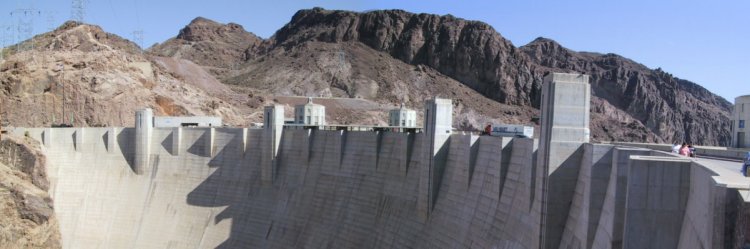
I decide that I might as well see the Hoover Dam while I'm so close. This was not on my original list of sights to see. I enter Boulder City at mile 1107.1 and continue on to Hoover Dam. They have a multi-level parking garage on the Nevada side. I park there in the sun because all of the good parking spots out of the sun were taken. I put a blanket over the interior to keep it from getting too hot.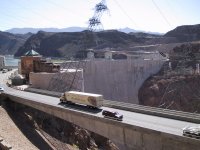
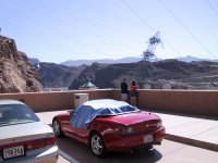

I'm looking for a gift shop where I can buy a postcard, but they're all closed except the one that is part of the paid tour package. I don't want to take the time for a tour, so I don't get a postcard of the dam.
I walk across the dam to the Arizona side just to see the whole thing. That is one massive chunk of concrete!9:55 a.m. - Mile 1117.3 - Leaving Hoover Dam
My Nevada map shows an interesting looking scenic route along Lake Mead that bypasses any more Nevada freeways and, more importantly, bypasses Las Vegas. In trying to find the road, I end up back in Boulder City, where I can buy and send a few postcards.10:35 a.m. - Mile 1129.4 - Leaving Boulder City, entering Lake Mead
I'm having a difficult time finding the road I want, so I go back towards the dam to the Lake Mead visitor's center. I find out inside that the road starts right there. I get a black brochure like all the national parks give out for Lake Mead National Recreation Area, with a map showing all the roads. The ranger there also gives me a photocopied map with the important turns marked in yellow. This is a big help. While I'm there I also by a National Parks pass for $50.00. Most national parks charge $10.00, with the bigger ones like Grand Canyon and Yellowstone charging $20.00. Fifty bucks is a good deal if you plan to visit many of them. It's a real good deal for me, with 12 total national parks to visit on this trip.

- Mile 1141.0 - Turnoff to the right
As I later discover, none of the national parks or recreation areas in the west have straight roads in them, they're all quite curvy. There's a great road along the edges of Lake Mead, with fresh, smooth asphalt and banked turns. It's also very clearly marked. If I had more time, I would be tempted to go back through this section several times. I really like this road.
When I stop, I discover one other advantage of a convertible. Flies and other bugs tend to get in the car when you stop. With the top down, they're all gone just a few seconds after you start driving again.
I take pictures of several interesting rock formations. It's good I came here before visiting Arches National Park, because these are totally boring compared to the rock formations in that park.


11:50 a.m. - Mile 1197.5 - Downtown Overton
I come out of the Lake Mead National Recreation Area at Overton and stop for a small snack. I'm back on the road at 12:10 after having something cold. Now I'm back in the heat and headed for I-15. I see no other way to get from here to St. George, Utah than take a few miles of interstate.12:25 p.m. - Mile 1209.5 - Interstate 15
As I get onto I-15, there's a black Mitsubishi Eclipse with four teenagers in it in front of me. I decide to blast on by as we merge onto the freeway. After all, I haven't used VTEC for a few hours. I set the cruise control on 79 and the black Eclipse eventually blows on by at about 95 mph. I'm tempted to show them who's fastest, but quickly get over it and let them fade on out of sight into the distance. Even though I have a radar detector, I want to keep to speeds that are not likely to get a ticket anyway. You never know when you'll be paced, or get caught with an instant-on unit. Safety is also a concern, especially when there is other traffic around.
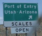
I cross into Arizona for a little while, then into Utah.

1:15 p.m. - Mile 1276.4 - St. George, Utah
I pull into St. George to get gas and another cold drink. The bank says that the temperature is 91 degrees. It feels a little hotter than that to me. If it's this warm in May, what's it like in July and August. I wonder why so many people are moving here from Northern Utah.I take Highway 9 towards Zion National Park.

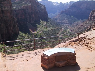
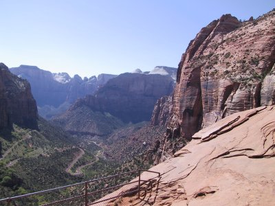
2:49 p.m. - Mile 1324.8 - Zion Canyon Tunnel
Apparently I missed writing down the exact point I got to Zion National Park. The walls of the canyon tower above you. It's much more impressive with no roof to block the view. Following the road through the canyon, I eventually reach the long tunnel that heads up through the cliffs. I later discover that about half of the national parks have tunnels in them somewhere.


The tunnel was built in the 1930's and was designed for two normal cars to be able to pass.
Most of the busses and motorhomes are either too tall or too wide to let another vehicle pass going the other direction, so they have rangers at each end of the tunnel controlling the flow of traffic. A bunch of cars go one way, then a bunch go another. I try taking a picture in the tunnel, without the flash, but set the camera incorrectly and the flash goes off anyway. The picture kind of shows what I intended anyway.
This tunnel is interesting in that they've cut windows every few hundred feet. I don't know if that's to help with ventilation or just to make sure they stayed the right distance from the outside of the rock walls when they built the tunnel. That's nicer than driving through a mile or two of total darkness.
I get out of the car at the top of the tunnel and decide to go for a small hike. By hiking for 15 minutes you can come out at the top of a cliff at the head of the canyon where the tunnel starts upwards. It's a beautiful view and well worth the hike. Somehow it seems strange not to see warning signs on the railing telling you not to do something stupid that would cause you to fall off the cliff. I lean over the railing a bit, but can't see the base of the cliff many hundreds of feet straight down below me. The ranger later tells me the he doesn't know of anybody ever having fallen off of there.
3:20 p.m. - Mile 1326.0 - Continuing onward from top of tunnel
I continue onward out of the park on Highway 9.3:48 p.m. - Mile 1344.8 - Mt. Carmel Junction
I stop at a gas station at the junction to get something cold to drink, write a few post cards, and send them off. I'm on my way by 4:10 p.m. I break my resolution not to have any drinks in the car. I sip on a cherry Icee for about the next 15 minutes of driving. Okay, no food in the car.5:35 p.m. - Mile 1412.5 - Lookout at Bryce Canyon
Once again I forget to mark when I entered Bryce Canyon National Park. The road between Zion and Bryce is a fairly high-speed 2-lane road through the mountains.
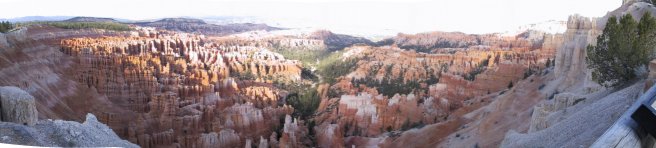
Right after I take my first panorama shot at Bryce Canyon, the rechargeable battery dies in my camera. I put the other non-rechargeable battery in and take more pictures. I actually have two regular batteries, but am hoping to not use up the first one. I find that I can take somewhere between 60 and 100 shots on the digital camera before the battery goes dead. That's not bad really.One of the lookout points in Bryce Canyon is 8100 feet. The high altitude is cooler and it feels good.
As I leave Bryce Canyon, I feel that I'll be lucky to make it to Kanab tonight. That's the only reasonably sized town in this entire area. I had originally planned to get to the North Rim of the Grand Canyon today too. Forget that.
As I'm driving back south on Highway 89, I accidentally bump the wiper switch and it smudges the bugs on the windshield. I try using the washer and it smears worse. Not only that, but the water mixed with bug juice goes to the side, up the side of the driver's side window, and drips down inside. I stop to clean the windshield properly.
6:42 p.m. - Mile 1476.4 - Passed Mt. Carmel Junction again.
Bryce Canyon was originally not on my list of places to visit, since it's out of the way, but since I was close enough, I thought I should go there. It turns out to be 130 miles out of the way and takes approximately 3 hours. Was it worth it? At least the roads were good, even if I didn't spend very much time in the park. I decide it was worth going out of the way.
7:00 p.m. - Mile 1493.4 - Kanab, Utah
I finally check into a motel as the sun is going down. I comment to the woman checking me in that she doesn't seem to have a Southern Utah accent like everyone else around there. She says that she grew up across the border in Arizona. I ask if it was Fredonia, and she says yes. I mention that a friend of mine in Pleasanton also grew up there and discover that he's her cousin. Small world.I also discover that the North Rim of the Grand Canyon is still closed for the winter - until Saturday. Looks like I missed it by two days. Oh well, that would have taken slightly longer than the trip to Bryce Canyon, so things have a way of evening out.
In checking out the pictures in my digital camera I discover that what should have been a picture of the sign entering Utah is just a grey blur. I have no idea of what the camera took a picture of, since I stopped for that one. Since I'll be entering Utah three more times, I'm not too concerned.
Thoughts From Day 3
It's fairly obvious that visiting three national parks is an absolute upper limit for one day. You really should spend a full day or two in each national park with more like a full week in the big ones like Yellowstone. Since visiting the national parks was only the third goal behind driving and getting to all of the western states, it doesn't bother me too much that I'm seeing them so quickly. However, I want to come back when I have more time.The North Rim of the Grand Canyon being closed will save me about 80 miles and two to three hours.
I've decided that I'm not going very far into New Mexico. There's nothing that I want to see there, I just want to say I've been there.
I decide that I'm not sleeping long enough, but I can't help waking up early. I'm not staying up late watching TV or anything.
I hope my leather seats like Coppertone Sport #8. It's tricky to drive and reapply sunscreen at the same time, especially on "interesting" roads.
Previous Next Home Site Map
Copyright (c), 2001 by Scott R. Nelson
Page last updated July 9, 2001
ScottRNelson@HotMail.com