
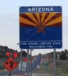
Thursday, May 10, 2001, 6:35 a.m. - Mile 1494.7 - Kanab, UT
It's actually 5:35 in California and Arizona, where I'm headed. The morning is cold, but there is a beautiful sunrise. On the way out of Kanab I stop to get gas and clean the bugs off of the windshield. I notice that there is getting to be quite a bug collection on my front bumper.
There are two routes 89 out of Kanab: 89 which goes mostly through Utah to Page Arizona, and 89a (alternate) which goes through Arizona and is marked as a scenic route on the map. I always pick the scenic routes when I get the choice.
Mile 1502.2 - Passed 389 turnoff in Fredonia
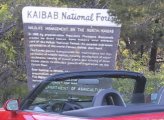
Mile 1519.3 - Kaibab National Forest
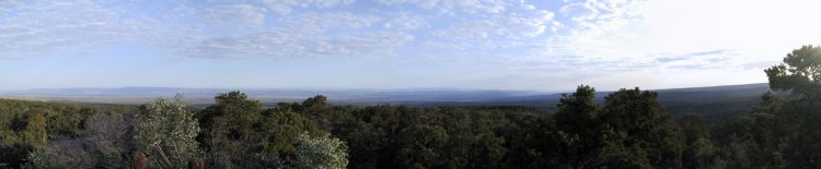

I drive up into the Kaibab National Forest, which is beautiful. Once again I'm wondering why I keep driving east in the morning. The road through the forest is a great drive and I'm glad I've chosen this route. It has nicely banked turns and a good road surface. It probably helps that I meet no traffic at all on this road. I would be heading south on Highway 67 to the North Rim of the Grand Canyon if it were not still closed until Saturday.
6:50 a.m. - Mile 1545.1 - Back out of the forest
I'm back on Arizona time, so it's really 7:50 in the time zone where I started. The roads are straight and clear and I find it hard to keep out of triple digit speeds, but somehow I manage.7:20 a.m. - Mile 1575.9 - Navajo Bridge


I stop at the Navajo Bridge across the Colorado River. The river doesn't look very big from however many hundred feet up I am on the walking bridge that crosses the canyon. This is another beautiful area. It's finally warm enough to remove my jacket.

7:40 a.m. - Mile 1590.5 - Back to the other 89
I meet back with the other Highway 89 and head south towards the road to the Grand Canyon. I keep it on cruise control to keep from going too fast on this rather straight road. At mile 1617.8 I accidentally run the speed up to 101 while passing a truck right after a place called The Gap. So much for my resolution to keep out of triple digit speeds, although I keep that goal throughout the remainder of the trip. If you don't back off of the throttle soon enough, the car just keeps on accelerating in 4th gear and would definitely pull strongly to redline. I've never bothered to find out at what speed the car stops having strong acceleration. I've heard that it tops out at about 147 or so.
The sun is now out and I forgot to put on sunscreen this morning. I need to steer with my knee for a few seconds to squeeze some sunscreen from the tube onto my hand. This is not nearly as easy as in a car like my Plymouth Voyager minivan. Any slight movement of the steering wheel makes the car change direction right now. This, of course, applies multiplies the force to my leg, which wants to steer more in the same direction. Corrections with my leg seem to want to lead to potentially dangerous oscillations. I make sure to only do this on straight and smooth roads. Most of the time I keep both hands on the wheel, which is the most natural way to drive this car.Once while I was in a carpool heading into Silicon Valley, I was going to comment to the person driving that he should really hold the wheel at the 9 and 3 o'clock positions. As evidence I thought I would observe a few dozen other drivers first and quickly found that only about one in ten drivers have both hands on the wheel, one on each side. Most used one hand on the top or one on the bottom. The Honda S2000 makes you want to hold the wheel in the proper position.

8:15 a.m. - Mile 1629.5 - Junction of 160
As I pass the junction of Highway 160, suddenly there is lots of traffic. Trying to see how many cars are ahead of me, I discover that Arizona puts a texture in the middle of the double yellow lines. I think this is a great idea. I like it better than the raised bumps that California uses. It's a good reminder when you're getting out of your lane. Most other western states don't do such things to their roads.A passing lane shows up and I manage to get by the four slow cars that have backed up quite a line of traffic. Many of the western states have sections of the two-lane road with three lanes, one in one direction, usually down hill, and two in the other. All of the other states that I've seen these in allow people in the one-lane section to pass when it is clear. Arizona, however, always has a double yellow line for the three lane sections.
8:27 a.m. - Mile 1646.7 - Road construction
I see a sign indicating reduced speed for a construction zone, followed by signs for 55, 45, then 35. There is a police cruiser with flashing red and blue and flashing headlights in the oncoming lane on the right. That's when I notice that the radar detector is unplugged. It's not a problem since I had slowed down as they intended. It's unclear if the police officer writes any tickets there or just makes sure that everyone slows down properly for the road construction. It seems to work very well at slowing traffic down.8:35 a.m. - Mile 1650.2 - Highway 64 to the Grand Canyon
Traffic is once again lighter as I head west on Highway 64 towards the Grand Canyon. It is at this point where I realize that the S2000 really needs better back support, especially for tall people. I've also noticed that the seat belt digs into my left shoulder after a while. I fold up a towel to put behind my middle back, which helps a bit. During the entire trip I don't find any other comfort problems at all with the car.9:05 a.m. - Mile 1682.0 - Gate of Grand Canyon National Park

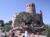

I drive into the Grand Canyon National Park and stop at just about every scenic view turnoff between the entrance and the lodge. It seems like there are about 30 of them. The first one has a stone building apparently owned by some Navajo Indians with a souvenir store in the bottom and a tower you can climb to get a better view. They charge 25 cents to go up in the tower, which is a definite bargain. Even though I probably have $5.00 worth of quarters in the car, I have to get change for a dollar bill before I can enter.
At one of the stops I meet a Miata owner that has to examine the S2000. I show him the engine and tell him a little about the car. I'm always happy to show the car off to those who are truly interested.

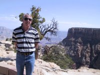
Whenever I see one person taking a picture of another with the Grand Canyon behind it, I always ask if they would like a picture with both of them in it. Many do and appreciate it. A couple of them were thoughtful enough to ask if I wanted them to take a picture of me with the canyon in the background. Here are two of a handful of picture I'm actually in from this trip:
My digital camera has a feature where you can take panorama shots by shooting several images as you pan the camera either horizontally or vertically. It shows you the last image and lets you match up the seams in the viewfinder to get each piece to match. I use the feature many times in the Grand Canyon. I manage to get over 100 pictures before the rechargeable battery dies.
12:20 p.m. - Mile 1710.9- The Lodge at Grand Canyon Village

I have lunch at the lodge, write a bunch of post cards, send them off, and generally rest for a while. I realize that I've taken a large number of pictures of the Grand Canyon and hope that a few turn out well. I've had enough of the Grand Canyon and am ready to head to Four Corners.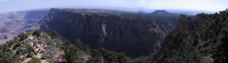
1:00 p.m. - Mile 1739.0 - Back to park entrance
1:30 p.m. - Mile 1770.5 - Back to 89 North
As I get back off of Highway 64 onto Highway 89 I'm expecting to be able to move along more quickly. Instead I run into construction traffic and we stop for 20 minutes. I turn off the car and stretch and others in line do the same. I have interesting conversations with several people and don't really mind the wait. The couple in the car behind me are from Alabama and came here specifically to visit the Grand Canyon. I realize that this will not be the last time I get stopped for construction on this trip.
1:50 p.m. - Mile 1770.5 - 89 North
The southbound traffic finally comes through and it is our turn to head north. When you have 30 or 40 cars in front of you, there is really no point in trying to pass them, since it could take hours to get by them all and only passing a few doesn't really get you anywhere. Several other cars try to pass anyway and I do what I can to make their passes as easy and safe as possible.2:05 p.m. - Mile 1786.5 - East on Highway 160
I split off of Highway 89 and head towards Tuba City, where I get gas. The gas gauge showed completely empty once again. At 2:30 I'm back on the road again.In one fairly straight section with no solid line in either direction I have to abort a passing attempt. Even though the lines indicated that I should be able to see oncoming traffic, a car suddenly appears out of a low spot in the road as I'm in the oncoming lane and almost to the vehicle I want to pass. I make use of the Honda's powerful brakes and pull back in behind to wait until it's really clear.
I resolve that from here on, I'll use the yellow lines on the road as suggestions only and make sure that I can truly see far enough for a safe pass.
3:30 p.m. - Mile 1870.5 - Kayenta, AZ
I had originally planned to continue on Highway 160 all the way to Four Corners, but the scenic markings on my map for Highway 163 through Monument Valley interests me, so I decide to drive up through there and come back on Highway 191. After all, it's less than 100 miles out of the way and should be a nice place to drive through.
4:00 p.m. - Mile 1894.4 - Utah border in Monument Valley

The drive through Monument Valley is beautiful and I'm glad I came. Southern Utah has the most wonderful rock formations.

4:18 p.m. - Mile 1916.2 - Mexican Hat
I find out why the town of Mexican Hat has such a strange name. There's a rock right out of town balanced on a round rock that looks just like a head wearing a Mexican Sombrero. I continue on Highway 163 towards 191.
4:35 p.m. - Mile 1936.5 - Head towards 163
As I glance at the map I notice that Highway 191 is basically a straight line southward that looks very uninteresting. Highway 163 looks more interesting and is also a shorter route to the Four Corners area. I change my route some more and decide to take 163.4:40 p.m. - Mile 941.5 - Passed through Bluff, Right on 163
4:55 p.m. - Mile 1956.4 - Montezuma Creek
At Montezuma Creek I go right, then left on 262 east towards Aneth. I find the signs slightly confusing, but manage to stay on the right roads.
I'm trying to take pictures of the signs entering each state to add to my collection. The Colorado border came as a sudden surprise and I missed the sign. I turned around and went back to get a picture of it. For a sign that says "Welcome to Colorful Colorado", this has to be the most drab sign of any of the 20 states I've been to recently. I thought that maybe because this is a "minor" entrance they might have spent less on this sign, but I later discover that they're all like this.
Highway C-41 is very straight all the way to Highway 160.
5:20 p.m. - Mile 1985.5 - Junction of 160
I turn right onto Highway 160 and head to Four Corners. Even though I've been to Southern Utah several times, this is one place I've never been to. If it wasn't for the curious fact that this is the only place four state borders come together, there would be no reason for anyone to come here and probably no reason to even have a road go by.


I pay the $2.00 entrance fee and take a picture of the car in front of the monument, showing all of the state flags. It's a good thing that I took the picture first, because I arrived at closing time and they start taking the flags down about two minutes after I get the picture. I just wanted to see the place, but some people have to have a picture taken with one hand and one foot in each state. I settle for a close-up of the official survey marker.
Upon leaving the monument there are state entrance signs for all but Utah within about 50 yards. Fifty yards is all the more of New Mexico you drive through on Highway 160. I head southwest towards Highway 64 to enter New Mexico for real.
5:50 p.m. - Mile 1997.9 - Junction of Highway 64
At Highway 64 I turn left towards New Mexico.5:55 p.m. - Mile 2002.1 - New Mexico state border

Wow! Have I really driven 2000 miles already? I finally enter New Mexico for more than just a few feet. My rechargeable camera battery dies right after I take a picture of the state sign. This has happened very afternoon so far. I'm hoping I can get by on just the rechargeable battery later in the trip.
6:20 p.m. - Mile 2024.6 - Shiprock New Mexico
I stop at the first real town in New Mexico, Shiprock for dinner. It also turns out to be the only town in New Mexico that I visit, since I don't see the point of driving further into the state. I think I've seen enough of New Mexico. I decide to take 666 back to Colorado and spend the night in Cortez. I don't think about it until later, but I should have looked for a rock shaped like a ship or something while I was in Shiprock. Oh well.I also notice one other thing in New Mexico. I'm not willing to go more than about 14 mph over the posted speed limit and I'm getting passed by everybody. I get passed by 20 year old pickup trucks, old beater cars, and even a semi carrying earth moving equipment. I don't mind, as long as they don't pass me and then later slow down again.
The road out of New Mexico is not smooth, like there's no base under the asphalt or something. The combination of the poor roads and a bit of wind tosses the car around quite a bit. The temperature is just right, though.
7:30 p.m. - 2070.2 - Cortez, Colorado
I finally get a motel room and stop for the night. I realize that my mileage estimate for the first half of the trip, all the way to Salt Lake City, was 1755 miles. I'm already over 2000, and still have three national parks to see. I hope the mileage estimates for the second half of the trip aren't so far off.
Previous Next Home Site Map
Copyright (c), 2001 by Scott R. Nelson
Page last updated July 9, 2001
ScottRNelson@HotMail.com