Some Pictures from Alaska

 This is a picture looking across Cook Inlet going down the highway to Portage Galcier.
The highway had to be rebuilt after the 1964 Alaskan Earthquake.
The road leads to the Kenai Peninsula, an excellent place to fish
for large Salmon during fishing season. It also leads to many of
my favorite places, including Seward and Homer.
This is a picture looking across Cook Inlet going down the highway to Portage Galcier.
The highway had to be rebuilt after the 1964 Alaskan Earthquake.
The road leads to the Kenai Peninsula, an excellent place to fish
for large Salmon during fishing season. It also leads to many of
my favorite places, including Seward and Homer.
 This is calved ice in Portage
Lake. The lake was formed from the melting ice of Portage Glacier. During
the Alaskan Gold Rush the trail to the gold fields crossed the galcier
and then went on to Nome. The lake was formed many years
after the gold rush. Many miners who could not afford ship
passage walked this trail to the gold fields.
This is calved ice in Portage
Lake. The lake was formed from the melting ice of Portage Glacier. During
the Alaskan Gold Rush the trail to the gold fields crossed the galcier
and then went on to Nome. The lake was formed many years
after the gold rush. Many miners who could not afford ship
passage walked this trail to the gold fields.
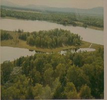 Tea Lake is property we owned and
reached by float plane. I got to name the lake, and have it put on the
map in 1968. We had a run-in with a large bear here one day
as we were flying in. The lake surrounds the island in this picture.
The mountain in the background is the Mt Susitna our cabin and
dog are named for.
Tea Lake is property we owned and
reached by float plane. I got to name the lake, and have it put on the
map in 1968. We had a run-in with a large bear here one day
as we were flying in. The lake surrounds the island in this picture.
The mountain in the background is the Mt Susitna our cabin and
dog are named for.
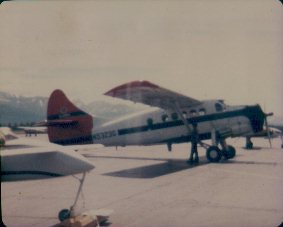 This is the aircraft I flew
most of my Civil Air Patrol missions on. There are some stories
that will be added to the Alaska pages about these flights.
This is the aircraft I flew
most of my Civil Air Patrol missions on. There are some stories
that will be added to the Alaska pages about these flights.
Return to Alaska Page
Return to Alaska Page
This page hosted by  Get your own Free Home Page