|
|
TeamManley |
|
 |
|
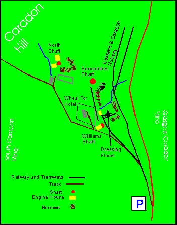 Not to scale. |
The East Caradon
Mine sett occupies the south eastern corner of
Caradon Hill. To its west
lay the rich ground of South Caradon
and the eastern boundary adjoins the Glasgow Caradon Consols. Around its lower section runs the trackbed of the Liskeard and Caradon Railway with a branch running up to near the dressing floors. The tramway running up to Seccombe's shaft was also the route of flat-rods. The remains of three shafts
exist and a fourth 'Footway' is lost in the area east of the Railway (ref
Dines). Within this sett some subsidiary buildings still remain in other
use, the most important of these is the ex-count house now the
Wheal Tor Hotel.
|
|
Information Sources CAU survey on Minions area 1st series OS Map OS 1:25000 119 Exploring Cornish Mines Vol 2:Brown and Acton |