If someone wants to reach the top of Mauna Kea, he or she should better get up early in the morning. So we did on that day in June '96. The nights at Namakani Paio campsite in Hawaii Volcanoes National Park can be quite cold because of the elevation (4000 feet). The night temperature was another reason to be up quickly and hit the road as soon as possible.
Our first stop was in Hilo, the largest metropolis on the Big Island. According to Lonely Planet's guide, the Harper Rentals is the only place on the Big Isle that allows its 4WD vehicles to be driven along the Saddle Road and to the top of Mauna Kea. We were thinking all the time that we could also drive up there with a regular car, but Hertz and all the other rental companies were not allowing that. So we decided to stick to the rules.
 A big Isuzu Trooper has already been waiting there for us.
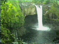
After stopping at the Rainbow Falls (picture!) just above Hilo for a while, we began
to climb up the steep and winding Saddle Road. The road crosses a huge saddle that separates
the two giants, Mauna Kea and Mauna Loa, therefore, it has been named appropriately. It is
50 miles long and there are no gas stations along it; perhaps this is the reason why this
road is banned by rental agencies. Maybe they don't want to constantly tow the careless drivers
that might just run out of gas. The road is paved all the way; in some places, there might be
a few holes but it is surely passable in a regular car.
A big Isuzu Trooper has already been waiting there for us.
After stopping at the Rainbow Falls (picture!) just above Hilo for a while, we began
to climb up the steep and winding Saddle Road. The road crosses a huge saddle that separates
the two giants, Mauna Kea and Mauna Loa, therefore, it has been named appropriately. It is
50 miles long and there are no gas stations along it; perhaps this is the reason why this
road is banned by rental agencies. Maybe they don't want to constantly tow the careless drivers
that might just run out of gas. The road is paved all the way; in some places, there might be
a few holes but it is surely passable in a regular car.  Hilo is at the eastern side of the island where pleasant winds from the ocean are blowing
constantly. But these winds are bringing rain. Hilo is considered to be one of the rainiest
towns in the world. So of course, this morning was also cloudy and rainy. But up along the
Saddle Road, in just a short time we reached above the clouds. Magnificent views of both
peaks have opened to us. Mauna Loa represents about two thirds of the island. It does not
have any steep walls and doesn't look that high at all. But the top is at nearly 14.000 feet
above the sea.That's around 4200 meters. This picture is showing the mighty mountain
reaching above the clouds. Mauna Kea on the north looks a bit steeper and is
not as wide as her southern twin. But it is even higher and its summit is accessible by car.
At the saddle top, we left the Saddle Road behind and turned onto Summit Road. First miles were
going through grassy ranchland, but the vegetation vanished soon. Only the red, brown and black
volcanic rocks and sand remained.
Hilo is at the eastern side of the island where pleasant winds from the ocean are blowing
constantly. But these winds are bringing rain. Hilo is considered to be one of the rainiest
towns in the world. So of course, this morning was also cloudy and rainy. But up along the
Saddle Road, in just a short time we reached above the clouds. Magnificent views of both
peaks have opened to us. Mauna Loa represents about two thirds of the island. It does not
have any steep walls and doesn't look that high at all. But the top is at nearly 14.000 feet
above the sea.That's around 4200 meters. This picture is showing the mighty mountain
reaching above the clouds. Mauna Kea on the north looks a bit steeper and is
not as wide as her southern twin. But it is even higher and its summit is accessible by car.
At the saddle top, we left the Saddle Road behind and turned onto Summit Road. First miles were
going through grassy ranchland, but the vegetation vanished soon. Only the red, brown and black
volcanic rocks and sand remained. After a few bends, we arrived to a Visitor Center. The official name is Onizuka Center for International Astronomy and it was named for Ellison Onizuka. This man was a Big Island native and an astronaut who died in the Challenger explosion back in 1986. The center was closed so we only stopped shortly. But it was impossible to overlook big warnings about the altitude sickness. People can do a trip from the sea level to more than 4000 meters in less than two hours here, with no time for their bodies to adapt to thin air. It is not uncommon to see someone getting real sick. But we were feeling great and continued to do the final part.
 After a while, we reached the top. There was nothing above us but clear blue sky. In fact,
the sky is so clear up here that the summit is full of observatories where scientists gaze
towards the stars every night. There is no pollution up here and no interfering lights from
the towns (the Big Island is not too populated) so this is a perfect spot for astronomers to
do their observations.
After a while, we reached the top. There was nothing above us but clear blue sky. In fact,
the sky is so clear up here that the summit is full of observatories where scientists gaze
towards the stars every night. There is no pollution up here and no interfering lights from
the towns (the Big Island is not too populated) so this is a perfect spot for astronomers to
do their observations. 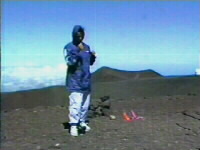 The astronomers work at night, of course. During daylight, the summit is
quite a lonely place. We only met a few workers up there and a soldier who had a day off and
decided to come up here. To our surprise, he knew quite a lot about Slovenia. In such moments,
I always think of many Europeans that I have met and who had no clue about our country.
They didn't
know where it was and what it was, and those who thought they knew a bit, usually had totally
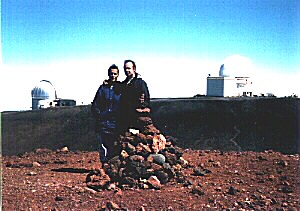
wrong and twisted ideas. But here, on the other side of the world, the man knows it all. This
picture is showing Brigita, not that soldier.
The astronomers work at night, of course. During daylight, the summit is
quite a lonely place. We only met a few workers up there and a soldier who had a day off and
decided to come up here. To our surprise, he knew quite a lot about Slovenia. In such moments,
I always think of many Europeans that I have met and who had no clue about our country.
They didn't
know where it was and what it was, and those who thought they knew a bit, usually had totally
wrong and twisted ideas. But here, on the other side of the world, the man knows it all. This
picture is showing Brigita, not that soldier. 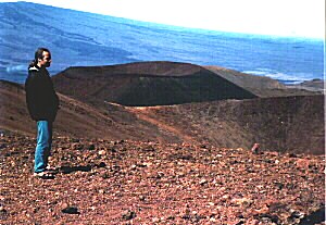 The views up here were magnificent. To the south, there was Mauna Loa. To the north, the
mighty Haleakala was reaching out of the clouds on the distant island of Maui. Towards east,
Hilo was hidden under a thick layer of clouds, and to the west, there was the sunny Kona
coast. And in proximity, a handful of cinder cones made this place look like a moon
landscape. As I have heard, the spacemen indeed were doing test drives with their lunar
vehicles here before actually using them on the moon.
The views up here were magnificent. To the south, there was Mauna Loa. To the north, the
mighty Haleakala was reaching out of the clouds on the distant island of Maui. Towards east,
Hilo was hidden under a thick layer of clouds, and to the west, there was the sunny Kona
coast. And in proximity, a handful of cinder cones made this place look like a moon
landscape. As I have heard, the spacemen indeed were doing test drives with their lunar
vehicles here before actually using them on the moon.  Brigita was driving downhill.
On the way down, it was a beautiful view towards the green grassy pastures along the Saddle
Road, however this picture looks back towards the summit, which is the peak on the right.
After a while, we were there again. But we were not ready to go back to Hilo. Not before
going up Mauna Loa. The road towards the summit was much worse than the one to Mauna Kea and it
didn't take us quite to the top. But it led us accross unusual lava fields and there were good
views towards Mauna Kea as we were climbing higher. After a while, we came to the weather
station and the end of the road. It was time to turn back and this time to go all the way to
Hilo. From weather station, it was about five hours of hiking to the Mauna Loa summit. We
could have done the hike if my foot was OK, but it was impossible with that injury. So we'll
leave this for our next trip to Hawaii.
Brigita was driving downhill.
On the way down, it was a beautiful view towards the green grassy pastures along the Saddle
Road, however this picture looks back towards the summit, which is the peak on the right.
After a while, we were there again. But we were not ready to go back to Hilo. Not before
going up Mauna Loa. The road towards the summit was much worse than the one to Mauna Kea and it
didn't take us quite to the top. But it led us accross unusual lava fields and there were good
views towards Mauna Kea as we were climbing higher. After a while, we came to the weather
station and the end of the road. It was time to turn back and this time to go all the way to
Hilo. From weather station, it was about five hours of hiking to the Mauna Loa summit. We
could have done the hike if my foot was OK, but it was impossible with that injury. So we'll
leave this for our next trip to Hawaii.  After final stop to take another glance to the mountains from the Saddle Road, we headed to Hilo.
We have returned just in time to return the Isuzu and to hit the road towards Captain
Cook where we have spent our final night on the Big Island. We stayed at the Manago Hotel and
next morning brought us a close encounter with Priscilla Presley (who
accidentally had her breakfast at the same hotel), but who cares about this story
anyway?
After final stop to take another glance to the mountains from the Saddle Road, we headed to Hilo.
We have returned just in time to return the Isuzu and to hit the road towards Captain
Cook where we have spent our final night on the Big Island. We stayed at the Manago Hotel and
next morning brought us a close encounter with Priscilla Presley (who
accidentally had her breakfast at the same hotel), but who cares about this story
anyway?