Darchen and the Kora
May 18, 1998
After breakfast, we begin an acclimitization hike from the guest house to Gyantak gompa. The gompa is to the north of Darchen at 16,150 feet. Since Darchen is at 4560m, or 14,960 feet, we must climb nearly 1,300 feet to reach the gompa. The trek is up a river valley, and we take 3.5 hours to arrive. Although it is sunny and almost warm in Darchen, the temperature drops suddenly on the way, and we even have a small hailstorm.
The gompa consists of two buildings. One is quite new, about 10 years old, where all of the resident monks stay. The other is a stone cube emplaced on a rock about 50 feet high; this building is over 800 years old.
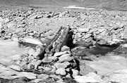
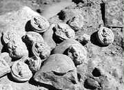 When we arrive all of the monks are busy making 4,000 tsa-tsas. These are small mud or clay objects which are formed in a mold. Once dry and hard, they are placed inside a chorten (the Tibetan word for a stupa) to enhance its religious or spiritual significance. In this case, they commemorate one of the monks who had recently died. They had cast a horoscope, and the horoscope determined that the tsa-tsas should be made. The photo at the right shows some tsa-tsas which were lying loose at Tholing, where they had spilled from a ruined chorten. These are about the size of an egg, and give an idea of what the monks at Gyantak were making.
There is another party of trekkers in at the guest house. These are a group of Swiss who are leaving the following day. They had made it to the top of the Dolma La pass, but they were forced to turn back because the yaks packing their gear could not traverse the snow cover on the opposite side. Although we are three days from arriving at the pass, we are worried that we too will be forced to turn around.
May 19, 1998
The day dawns sunny and warm. We start out from the guest house about 9:00am heading west along a well marked trail that mounts gently toward the first "prostration site". This is the top of a ridge marked by a rock cairn and the typical collection of mani stones and prayer flags. We reach this in about an hour and a half and stop for a rest. Here we are at 4730m or 15,518 feet. At this point the route turns north following the Lha Chu river along the west flank of Kailash. A couple of hours more along a relatively flat river valley floor brings us to Tarboche, a large flagpole that is redecorated with prayer flags during the Saga Dawa festival, to be held in two weeks.
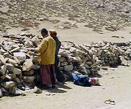
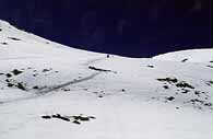
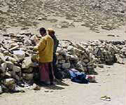 At this point we see two men performing the Kora in prostrations. This means that they prostrate themselves fully on the ground with their arms extended past their heads. Then they rise, walk to the point where their fingertips touched, and repeat the same actions. Generally they say a mantra with each prostration. This activity can take several weeks to complete the entire Kora. Each morning, the pilgrim carries his belonging to the end point of the day's effort, returns to the previous point, and begins again. Once begun, this journey must be completed, and the penitent cannot skip the hard parts of the trail. Thus he may be forced to prostrate in snow, mud, sharp rocks, icy streams, and so forth. Obviously this is not a task for the weak or uncommitted! I had seen them in the distance prostrating, but by the time I had arrived in photo range, they had stopped (for lunch?) and were arranging the stones on the mani wall seen in the photo. Both had a sort of leather apron that covered the front part of their bodies from the neck to the shins, and both had thick leather gloves. Later on, I would realize that this portion of the Kora was the easiest; as I was picking my way through sharp rocks, snow, and boulders in the coming days, I often thought of these two men and the ordeal that they would face later on. Despite meeting many other Tibetans on the Kora trail, I saw no more prostrators. I think it was early in the season for this difficult task.
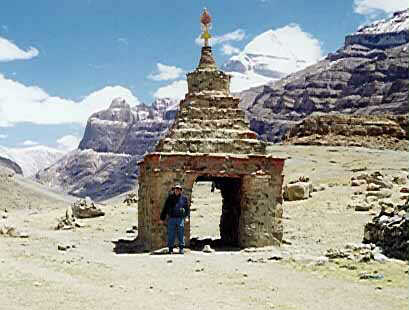
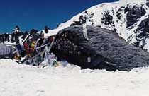
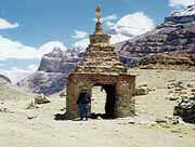 A short distance past Tarboche is the well known Kang-Ni Chorten, which has a passageway through it. It is considered good luck to pass through the opening. The photograph shows me (dimly) posed before the chorten, and the snowy summit of Kailash in the background. I walked through the chorten, not wishing to miss out on any available karma, to discover a half-decomposed goat's head hanging at the rear.
We make camp early, around 3:00pm, just past the chorten along the banks of the river. The reason for an early stop is that this is the last place along the trail that our vehicles can reach. After this, all our gear for the next three days will be carried by humans and yaks. For this reason, we are asked to leave all unnecessary gear with the vehicles. Also, those with individual tents will have to double up during the next two nights.
I take the opportunity to wash out some clothes and rest in my tent for the remainder of the afternoon. I am reading the book Into Thin Air about the disastrous Everest expeditions in 1996. Somehow in comparison our little jaunt doesn't seem so difficult or perilous.
Some of the more energetic in the party climb the cliffs to the east to visit a sky burial site just above the Tarboche flagpole. Those of you who have seen the movie Kundun will know what a sky burial is. Since Tibet is rocky and treeless, burials or cremations are difficult. The traditional method to dispose of the dead is to cut up the bodies and leave the pieces exposed for vultures to eat. At higher altitudes, such as at Kailash, vultures are in short supply, and wild dogs must perform the duty.
May 20, 1998
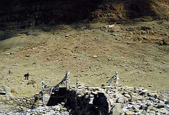
We start out at 10:00am, still following the river valley. A short walk brings us to a stone and log bridge, above which is the Nyanri gompa on the opposite bank.  There is a large pile of packs belonging to pilgrims, who have left them in order to climb to the gompa high above. This bridge is a decision point between two routes for the Kora. if you remain on the east bank, the route is shorter and easier. However, being close to the foot of Kailash there are few views of the mountain. The west bank offers great views of the western and northern faces of the mountain, but also a more difficult walk. While we are at the bridge, we see the pilgrim party descending from the gompa. They are a large group of adults and children, all of who seem happy to be here, smiling and laughing. They are quite shy, and most indicate that they do not wish to have their pictures taken.
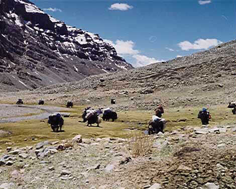
Our route lies to the west, and we cross the bridge. Several of our party decide to climb to the gompa. Since it looks to be about 1000 feet above us, I decide to save my energy for the day's hike, and carry on with two others. The route here is just to follow the riverbank, walking over scree (gravel) and climbing gradually. A couple of hours more brings us to a meadow where the yaks carrying our gear catch up to us. As it turns out, we are to have lunch here, so we sit down and wait for the rest of the party to arrive.
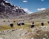 A few words about the porters seem in order. When in Darchen, our guide had stumbled across a family group of pilgrims from eastern Tibet that was here to do the Kora. Knowing that it would be difficult to cross the Dolma La pass through the snow, he had hired them as porters for the Kora. Normally it is almost impossible to hire porters in Darchen, so this was a stroke of luck for us. However, the yak porters in Darchen have a sort of monopoly. If our guide had failed to hire them as well, subsequent treks by Snow Lion would have been black-balled. Thus, we have the yaks carrying our gear only for today, and the human porters for the following two days.
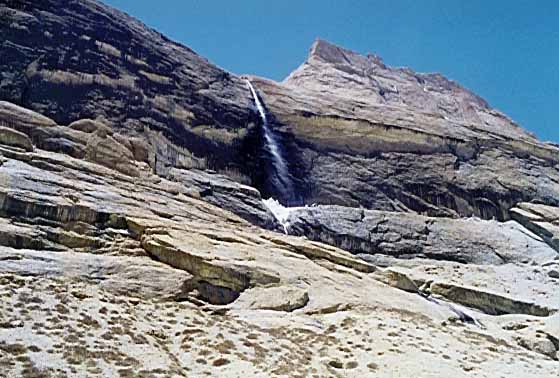
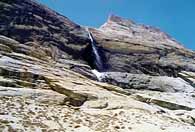 The trail continues on for several hours following the river, which is quite high because of the snowmelt. In some places we are quite high above raging whitewater. I come to the realization that a fall means a fatal meeting with rocks and freezing water; this thought has the effect of concentrating the mind on what I'm about. The valley walls to the west rise high above, and there are several waterfalls that feed into the valley. At one point we see a large herd of wild sheep grazing on what appears to be a sheer rock face. It is along this stretch that I meet our lama; we walk along together in silence for a while, until he picks up the pace and leaves me behind.
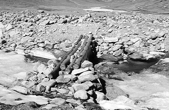
 Late in the afternoon, the valley widens and the river becomes spread out across a wide alluvial bed. The trail passes through fields of rock, and we cross several feeder streams over log bridges. The final stretch of a couple of hours is relatively flat and rocky. We arrive just before dusk at our campsite below the Diraphuk monastery. Our lama is a guest in the monastery itself, and we won't see him again until the end of the Kora. The yak porters have pitched a skin tent just above ours. The Tibetan nomad tents have an opening in the top which serves as a chimney, since they build campfires within. Apparently there is a type of gambling game going on inside, a feature of which is to slam something down making a loud clap. I am invited inside to watch, but the smoke is so thick within that I quickly back out. Some of our guides do participate in the game however.
Across the valley, we see campfires of pilgrims in the distance, shining out against the hillside. These fires flicker on and off regularly. I later see why. Because of the thin air, fires do not burn well. The Tibetans have a type of skin bellows which they use to pump air onto the fire. Each puff of air causes the fires to flame up, and then die down again quickly.
The campsite at Diraphuk yields some of the best views of Kailash's north face. I take some of my better pictures here.
May 21, 1998
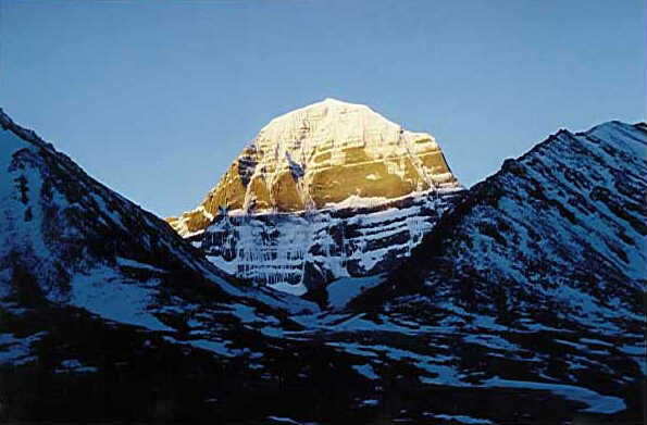
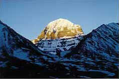 Today we cross the Dolma La pass. Before setting out, I take this photograph of the north face of Kailash at sunrise. Starting out at 7:45, the route crosses the Lha Chu river via a bridge, and immediately climbs a huge steep moraine. Then it turns into a rocky path that mounts less steeply. In the valley below one can see the path for pilgrims who have taken the east bank route. Soon their route merges with ours as we must climb over more boulders. It takes 4 hours to arrive at the base of the pass. Until now, we have had to contend with scattered patches of snow; however the pass itself is completely covered.
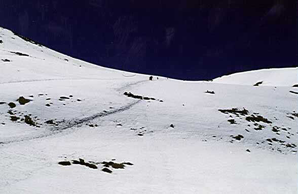
 All of the pilgrims are climbing more or less straight up following the same trench in the snow. Normally one would climb in a zig-zag manner, so this route is shorter but much more steep. I take 90 minutes to make this final ascent, before arriving at the top. The altitude here is 5630m, or 18,471 feet. Here we eat lunch in the snow, breathless and elated at the same time.
 The crest of the pass is marked by an immense prayer flagpole, with several of the supporting ropes connected to a large boulder representing the goddess Dolma. The tradition is to walk around this boulder three times for luck, and then to leave an article of clothing, while taking an article left by another. Many of the pilgrims paste money to the boulder with butter as an act of piety.
Following lunch and a rest, we commence the descent of the far side of the pass. Once over the crest, we can see the location of the Gouri-kund, or Lake of Mercy, one of the highest lakes in the world. Today, however, the lake is frozen and covered with a blanket of snow, so that all appears like a snow bowl. The initial part of the descent is once again over a snow-covered moraine, and we are forced to test each step with our poles. It is evident why yaks cannot make this descent in the snow. One misstep can result in wedging a leg between boulders. Eventually the moraine ends and we are in a relatively flat, snow-covered stretch that appears to be an easy walk. In reality, this stretch is one of the most difficult and exhausting. The snow has softened under the mid-afternoon sun, and I continually sink into the snow up to the hips. Extricating myself each time is hard work. I imagine that I sank at least 50 times!
All ordeals must come to an end, and after an hour or so, we arrive at a rocky portion free of snow, and then follow a steep rocky descent to the floor of the Lham-chhukhir valley. Here we find our porters waiting to set up camp. However, the guides decide to camp further along the river, and we have another kilometer or so of walking before finding the camp at 7:30pm
Despite the difficulties of the day, everyone completes the pass with a feeling of elation and accomplishment. Dick Zody, still sick with dysentery, comes into camp two hours after the rest of us. He too had trouble crossing the snow field. Completing such a day while ill was certainly grounds for congratulations, followed by a welcome night's sleep.
May 22, 1998
 The final day of the Kora is somewhat anti-climactic. The route lies along the right bank of the river, crossing several tributary streams. It then mounts the valley wall somewhat steeply until it reaches a bluff. Here, several long ropes bearing prayer flags are strung completely across the valley.
This fourth day we leave camp at 10:45am and arrive at the rendezvous with our vehicles after 6-1/2 hours on the trail. We are still about an hour's walk from Darchen, and two of our party elect to "officially" complete the Kora by hiking the final stretch along a flat dusty road. I am content to ride. Arriving in Darchen, the occupants of our landcruiser pay a visit to the Darchen tea shop where we try the local buttered tea and some noodles. The tea is quite good (I am told) since the butter is relatively fresh, and the noodles are delicious. The tea shop is a dimly lit single room with a propane stove in one corner and tea served from large thermos bottles. There are three Chinese men inside drinking beer from a single shared glass. I try to take a photo, but even with the flash the picture is very dim.
Having finished our snack, we remount the landcruiser and drive for two hours towards the west, finally making camp beside a rushing stream.
Page 9
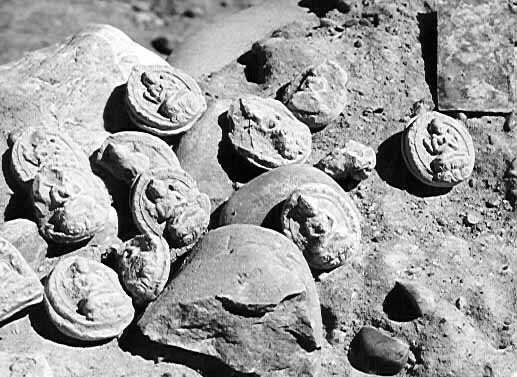 When we arrive all of the monks are busy making 4,000 tsa-tsas. These are small mud or clay objects which are formed in a mold. Once dry and hard, they are placed inside a chorten (the Tibetan word for a stupa) to enhance its religious or spiritual significance. In this case, they commemorate one of the monks who had recently died. They had cast a horoscope, and the horoscope determined that the tsa-tsas should be made. The photo at the right shows some tsa-tsas which were lying loose at Tholing, where they had spilled from a ruined chorten. These are about the size of an egg, and give an idea of what the monks at Gyantak were making.