To the Arctic Circle and beyond on the Dalton Highway

The Dalton Highway is a road that was not built for small cars. To quote a seasoned user of the road upon seeing our car in Prudhoe bay - "That car has no business being on the Dalton Highway". In fact the chances of making it all the way to the end and back without serious bodily harm (or a puncture at least) if driving in a small car are slim to say the least. Our car was the smallest on the road by far, and maybe the oldest too! Nontheless, our little car did a magnificent job of getting us to Prudhoe Bay and back without so much as a puncture.
The Dalton Highway is a well maintained dirt road that follows the pipeline up north to Prudhoe Bay. Along the way it crosses the Yukon River, goes over the the Arctic Circle and traverses the magnificent Brooks Range. It then dives down onto the northern slope, a flat area of northern tundra, and snakes its way north following the Skag River until it reaches Deadhorse and Prudhoe Bay.

The Brooks Range has two distinct sides - the southern side is made up of beautifully mountains with glacially carved rock formations. Each mountain has been scraped and gouged by the now disappeared glaciers that covered the land eons ago. Each peak is magnificent and the sides are covered with oldgrowth pine forests and gurgling rivers with cold, clean water speeding southward.

The northern side of the range is a jumble of splintered, crumbling rocks where little vegetation grows. The cold weather has obviously playing a large role in creating this lunar landscape. The contrast between north and south is stark as you make your way over the northern continental divide.
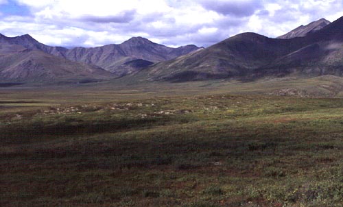
As you leave the mountains behind you the northern slope quickly takes over with its undulating hills of tundra, herds of caribou, brown bears and if you are lucky, a rare sighting of musk ox in distance. In summer many birds breed here in the soggy, spongy tundra. Birds such as Long-tailed and Arctic Jeagers, a host of shorebirds, and even some Asian migrants are found breeding here (such as the Bluethroat).
This page hosted by