I will provide links to reference pages as
well as other interesting sites you should visit to learn weather more
in depth.
CLOUDS:
A cloud is simply condensed water floating in the atmosphere. The water got there by being heated by the sun, vaporizing (called evaporation) and being cooled in the atmosphere, condensing into a cloud. A cloud forms many shapes and sizes, but the basics of a cloud are all similar.
Water comes in three forms as known from chemistry: Solid (ice), Liquid (Water), and Gas (steam or vapor). A puddle, of water on the ground is in its liquid state, and when heated by the sun, it transforms into a gas state: water vapor. As ground is heated, the water is heated, transforming it to vapor and the vapor rises. Once it reaches a certain height in the atmosphere where the air is cooler and can no longer hold the vapor (explained later), it condenses back into a liquid form, but still small enough to remain suspended in the atmosphere. Actually, it's form is more or less still in an in-between stage of liquid and gas as it now becomes able to refract light causing us to be able to see it. This is also why it can block the sun's light. Now the water is considered a cloud.
 (Thanks Allstar, and Matt.)
The level of moisture in the air is dictated by the temperature. Air can hold more vapor when it is warmer. When it cools, the vapor either condenses and forms fog, or a cloud; Or it condenses and forms a cloud, but precipitates the moisture that it can no longer hold. This happens on the ground at night when radiational cooling (the cooling of the earth when the sun goes down at night. This happens more noticeably when there are no clouds in the sky) cools the atmosphere near the ground. Here the air can not quite hold the total amount of moisture in the air, but it isn't high enough to cause rain, but since the ground is cooler (or the grass, cars, etc...) is cooler, moisture condenses on those points causing dew. Fog is similar to a cloud, but happens on the ground.
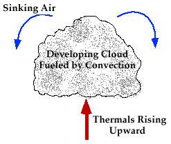
A cloud that forms higher in the atmosphere is created when the water vapor is at a level in the atmosphere where the air is cooled to its condensation point. The type of cloud and the height of the cloud depends on the time of day, the upper level winds (the winds aloft), the time of year, the amount of vapor in the air and the temperature. Several other factors are involved, but for our purposes, we'll keep it simple. As the vapor reached the point of condensation, it condenses and a cloud is formed, and if there is a lot of vapor and the air is cooled quickly, a larger cloud is formed and it then precipitates (rain, snow, sleet, hail).
If there is so much moisture and cooled air that clouds form higher and higher, cumulonimbus clouds are formed. These clouds are the thunder clouds, which can reach as high as 39,000 feet where the temperature can reach below 0 Fahrenheit! In this cloud, a separate atmosphere is created in which updrafts are created which brings more moisture within the cloud-actually feeding itself- making the cloud larger and larger. This phenomenon will be further discussed in the Thunder and Lightning section of this page.
Some of the clouds and there names are:
 CUMULUS: These are the
beautiful, white, puffy, "fair weather" clouds. The are also the start
of what could become a CUMULONIMBUS- or thunderstorm cloud. They are created
in the mid- to lower levels of the cloud producing atmosphere (troposphere
or stratosphere-high level). Often they are the clouds that show up before
a cold front approaches.
CUMULUS: These are the
beautiful, white, puffy, "fair weather" clouds. The are also the start
of what could become a CUMULONIMBUS- or thunderstorm cloud. They are created
in the mid- to lower levels of the cloud producing atmosphere (troposphere
or stratosphere-high level). Often they are the clouds that show up before
a cold front approaches.
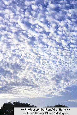 ALTOCUMULUS: Created
in the Troposphere near the Stratosphere, composed mostly of ice crystals
due to the heights at which they are created. At higher levels in the atmosphere,
the temperature drops significantly.
ALTOCUMULUS: Created
in the Troposphere near the Stratosphere, composed mostly of ice crystals
due to the heights at which they are created. At higher levels in the atmosphere,
the temperature drops significantly.
 STRATUS: These clouds are
the dreary day clouds that can create rain, and are most associated with
the fronts that approach. The rainstorms they produce do not produce thunder
and lightning. They are flatter and can reach the mid- to upper levels
of the atmosphere. These may be dreary, but they can create some spectacular
cloud formations as well. Note the wavy look at the picture above.
STRATUS: These clouds are
the dreary day clouds that can create rain, and are most associated with
the fronts that approach. The rainstorms they produce do not produce thunder
and lightning. They are flatter and can reach the mid- to upper levels
of the atmosphere. These may be dreary, but they can create some spectacular
cloud formations as well. Note the wavy look at the picture above.
CUMULONIMBUS: These
are the thunderclouds that produce storms, tornadoes, hail, and high winds.
Note the anvil shape at the top of the storm. That is created when the
cloud tops form in the Stratosphere and the upper level winds push the
cloud along. These clouds can reach heights of 39,000 feet. The storm cloud
actually produces its own winds within the cloud and these are updrafts.
The updrafts can make the water vapor turn to droplets, and then to ice
by forcing the water drop to the upper reaches of the cloud. The ice becomes
to heavy and it drops. If the winds are strong enough, the ice will get
near the bottom of the storm, be picked back up, and similar to building
a snowman, will grow larger as more water droplets adhere to the formation.
At some point, the ice (called HAIL) is too heavy and finally falls to
the ground and can cause substantial damage. The hail is also responsible
for creating the lightning of the storm. (see Thunder and Lightning).
(Picture unavailable)
CIRRUS: These are clouds created at the uppermost atmosphere where the water vapor did not condense at a lower level to produce a water vapor cloud. Instead, the water vapor actually froze creating these clouds. Often these clouds are predecessors of a cold front and thunderstorms.
These are the basic clouds we see most often in the sky. There are more
and you can visit The
University of Illinois weather department to see more and learn more
about clouds and their formation.
Of course another location is The
Weather Channel web site which has a wealth of information about weather
in general.
Intellicast weather
is another source for information.
![]()
Eric Tallberg
Please e-mail me with comments!
