|
This area offers the best horseback
riding trails in the Patapsco State Park.
 | Basic Conditions:
 | Accessible trailer parking on grassy lot
with plenty of turning area and nearby restroom facilities.
|
| Looping trails with river crossings, flat
hardpacked or sandy riverside areas and more challenging hills with some quite rocky
areas.
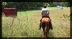 |
| Mike approaches the
parking from the back of the field. The white trailer is facing the entrance area. |
|
| A favorite ride among locals is to cross
the river and follow the trails to the Woodstock Inn which even has a hitching post
outside. The final part of this trip involves climbing a steep hill right beside a
railroad track. We usually stop just short of that phase!
|
|
 |
 |
| Markers include
horseshoe-shaped blazes as well as traditional rectangles. |
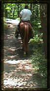
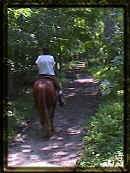
An example of one of
the nice flat riverside trails |
| Potential Hazards:
| Many, many mountain bikers
|
| Hikers unfamiliar with horses
|
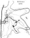
| Steeper hills require attention to
footing, particularly steep areas are found at the north end of the park, leading from the
pavillions behind the trailer parking on the maps below. It is easier to follow the
gravel road out the back of the trailer parking. It leads to the dotted path, a nice route
down to the river trail. We usually turn right when reaching the river trail at the
bottom because there is a large area of slippery granite surface further down. As an
alternative, follow the gravel road out of the lot, but do not take the right fork onto
the dotted path. Instead turn left and look for an unmarked trail to your right and
take it down. it is quite scenic and not as steep as the one from the pavillions.
|
| Some riverside areas have experienced wash
out of the banks. Be alert when you are right along the banks.
|
|
| Rules & Restrictions:
| Use fee of $2.00 per adult applies during
weekends and summer
|
| Remain on marked trails and obey "NO
Horses" signs
|
| No hunting and no dogs permitted.
|
|
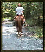 |
An example of one of
the rockier sections. |

Park Map
Map thumbnails appear below. Click
on it to view larger map.
Use your browser's BACK button to return to this page

Pay special attention, directions are
different East versus West due to exit configuration from Route 70
| Directions from the East:
| Take Route Route 70 West To Exit
83 - Marriottsville Road
|
| Bear right at the end of the ramp
onto Marriottsville Road
|
| Proceed through the traffic
signal at Route 99
|
| Cross the railroad tracks and the
river, pass Henryton Road, Marriottsville Road #2 and Ridge Road (all on your left)
|
| Look for the park entrance on
your right.
|
|
| Directions from the West:
| Take Route Route 70 East To Exit
82 - Route 40
|
| At the first traffic signal, turn
LEFT onto Marriottsville Road
|
| Cross route 70 and proceed
through the traffic signal at Route 99
|
| Cross the railroad tracks and the
river, pass Henryton Road, Marriottsville Road #2 and Ridge Road (all on your left)
|
| Look for the park entrance on
your right.
|
|
Please write if you have any questions or
comments: e-mail
 Visitors
since 07/31/2000 Visitors
since 07/31/2000
Last updated 07/31/2000
|