|
 |
|
Difficulty Level
(very easy, easy, medium, slightly tough, tough)
|
Very easy |
|
Duration of the trek
|
1 day
|
|
When to visit
|
Anytime except summar |
|
Nearest City / Location
|
Kalyan (कल्याण),
Murbad (मुरबाड),
Junnar (जुन्नर) |
|
Base Village
|
Vaishakhare (वैशाखरे)
from Kalyan/Mumbai end
Ghatghar (घाटघर) from Pune/Junnar end |
|
|
Naneghat trek is one of the best Monsoon treks.
Naneghat speaks very old history which is hardly clearly known to commons.
This ignored pass once served a vital trade route between Kalyan and Junnar.
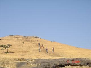
Naneghat trek is simple and enjoyable. Way is
clearly marked and passes through dense teakwood forests. Climbing from the
forest you reach to the base of 'Nanacha Angatha' (नानाचा अंगठा) which is
pinnacle of Naneghat plateau.
From this base, a 2 meter wide pass connects to
the actual plateau. This pass called as 'Naneghatachi NaLi' (नाणेघाटाची नळी)
has been carved and cut in stones by emperors of that time. This 60 meter
long pass takes you to the Naneghat plateau.
NOTE - Naneghat plateau has vehicle
route till its top from Junnar/Pune side. So private vehicles can directly
reach the pleateau and enjoy the monsoon beauty of Naneghat.


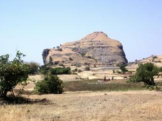
Naneghat plateau (नाणेघाट पठार) |
|

-
Trade Route
(कल्याण जुन्नर व्यापारी मार्ग) - Naneghat was built
around 2000 years ago to serve as the shortest path
between Kalyan and Junnar. While Junnar served as capital
of many dynasties like Chalukya, Saatvaahan, Shilahar
etc., Kalyan continued to remain an international trade
center. These kings built some forts around Naneghat to
keep watch on the trade route.
-
Guarding
Naneghat - Naneghat is guarded by four forts - Jivdhan,
Hadsar, Chawand and Shivneri. Jivdhan fort lies right
beside the Naneghat plateau. Shivneri lies at the back of
Junnar city.
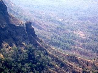
-
JIvdhan fort and Khada
Paarshi Pinnacle
(किल्ले जीवधन आणि खडा पारशी सुळका) - Jivdhan is
considered to be one of the tough forts to climb and the
steep niddle shaped 'Khada Paarshi Pinnacle' beside it is
one of the peak attractions of rock climbers. This fort is
most importantly situated to guard Naneghat plateau.
-
Naneghat
Caves (नाणेघाट गुहा) - After Saatvaahan kings
conquered and started ruling this area, they renovated the
forts and the pass and carved some caves for the stay of
traders. The largest cave of Naneghat bears stone carvings
and some Sanskrit writings in brahmi and devnaagri script.
Sculptures of first Saatvaahan king - Shalivaahan have
also been carved in the cave. This Shalivaahan started the
famous Marathi calendar 1950 years ago called as
Shalivaahan Shak, which is still widely used. The scripts
also mention some yagnya and donations performed by
Saatvaahan queen.
-
Water
cisterns - In and around the caves at the base of
Nanacha Angatha, there are many water
tanks that bear water even in summer. They were created to
facilitate the traders for their stay in the caves.
-
Naneghatachi
Nali
(नाणेघाटाची नळी)
- This 60 meter long and 2 to 4 meter wide pass has been
manually cut through rocks when there were no advanced
cutting tools. The pass and the whole route was built with
stone in such a way that bullock carts and horse carts
could climb and pass through easily.
-
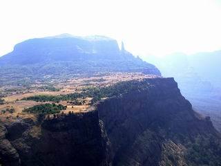
Naneghat
plateau (नाणेघाट पठार) - After you cross the Nali, you
reach a huge plateau on the top. This Naneghat Pathar is
really huge and exceptionally plain giving a good view of
the tough fort Jivdhan.
'Nanacha Angatha, which is peak of Naneghat can
be reached easily from here.
-
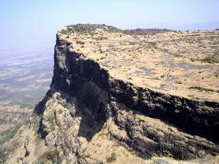
Nanacha Angatha (नानाचा अंगठा)
- This peak of naneghat is thumb shaped, hence the
name. This gives a good view of the valley, fort Jivdhan,
fort Harishchandragad and Naneghat Plateau. You can
not resist clicking snaps for half an hour from here.
-
Stone Pot (दगडी रांजण)
- The famous stone pot called as 'Raanjan (रांजण) of
Naneghat' which is 4 feet in height and 3 feet in
diameter, was used to collect toll from the traders. The
Raanjan used to contain the coins of that age called as 'KaarshapaN'
(कार्षापण). In front of the stone pot lies a Ganesh idol
in a small temple.

Stone Pot (दगडी रांजण)
Naneghat plateau (नाणेघाट पठार)
as seen from Nanacha Angatha
Base of Jivdhan fort
as seen from Nanacha Angatha |
JIvdhan fort and Khada Paarshi Pinnacle
(किल्ले जीवधन आणि खडा पारशी सुळका)

Naneghat Caves (नाणेघाट गुहा) and Water cisterns

Naneghatachi Nali (नाणेघाटाची नळी)
Nanacha Angatha (नानाचा अंगठा)
as seen from Naneghat plateau
Nearby places to visit
-
Shivneri fort and other places around Junnar -
Junnar is just 1 and 1/2 hours from Ghatghar. The fort
shivneri at Junnar is the place where Shivaji Maharaj was
born. An excellent well maintained fort speaking 2000 years
old history. Refer to Shivneri
information for details.
-
Malshej Ghat (माळशेज घाट) - On the current way from
Kalyan to Junnar lies Malshej Ghat where more than 30
waterfalls fall down on the road in Monsoon. One of the
favorite monsoon picnic spots amongst Mumbai-Pune residents.
-
Harishchandragad fort - The glory of trekking - Love
of trekkers. This fort is a bit tough one, but what it has
for display simply ineviting. Taramati mountain - second
highest peak of Maharashtra; 2000 feet deep steep
semicircular concave Konkan Kadaa; 600 feet rock patch
for trekking; 2500 years old Harishchandreshwar temple...
Refer to Harishchandragad
information for details.
-
Jivdhan fort - Base village of the fort is Ghatghar. One of
the really tough treks.
-
Hadsar and Chawand forts

-
To Mumbai - Get down from Naneghatachi Nali to
Vaishakhare and take ST to Kalyan.
-
To Pune - Walk for 5km on Naneghat Plateau to reach
Ghatghar and take an ST to Junnar, from where you can reach
Pune easily.

|
From
Kalyan to Naneghat / Vaishakhare
|
Every half an hour bus to Ale Phata / Nagar
(आळे
फाटा / नगर).
Get down at Naneghat stop.
|
|
First bus |
5.30am from Kalyan |
|
Last bus |
12.15am from Kalyan |
|
From Ghatghar to Junnar
|
3.00pm from Ghatghar
(every two hourly bus till 4.30pm)
|
|


