Jeff and I have
backpacked a good portion of the island.
We’ve see all the campgrounds accessible by two feet excpet for: Malone
Bay, Todd Harbor and Lane Cove.
Although many more are only accessible by kayak/canoe/ferry. Most of the campsites reachable by foot we
have camped in, although some we just passed through or had lunch.
The
information section was taken from Isle Royale’s homepage. This is all written by me, but Jeff has
given me his comments and I’ve added them.
No
campground on Isle Royale is a bad campground.
They are all very beautiful and which is a person’s favorite is very
subjective.
I
like having a nice shelter also. Isle
Royale has many 3 sides shelters with a screen acting as the 4th side. They keep out the bugs, give added
insulation from the wind and rain, and generally make sleeping and backpacking
easier. And all campsites are,
relatively, near a water source.
Costs
The largest lump cost
will be the ferry tickets. They will
cost anywhere from $70-90, depending on where you are leaving from. The prices change, so check the ferries for
their current rates. Next you have the
$4 per day per person User Fee. 2
people on the island for 5 nights would cost $40 total. If you already have your equipment the only
other costs are your food, gas and personal vices. 5 days is going to cost anywhere from $50 to $100. It is an art form, getting your camping
food. On the island you’ll want some
cash. The snack bar is expensive, but
nothing beats an order of greasy fries.
The
grocery sells most camping supplies…
extra batteries, can fooded, some freeze dried food, some fresh food,
cigars, magazines, and other junk.
Their supplies are mostly stuff you shouldn’t buy.. like ramens and
canned food before your journey. The
visitor center sells neat pins, books, posters, maps and dates with the
Rangers. You could pull the trip off
for under $150, but it would be hard, especially if you have to drive far. I usually spend $200-$300 on the trip. And I usually wish I had more money. A few times we barely had enough to pay our bridge
tax coming into the lower pennisula.
The Trails
Most
trails are not for beginners. Either
they are rocky or muddy or you have to balance across logs as not to fall in a
beaver pond. Mud mud mud. Isle Royale is usually very wet when you are
not on the ridges. Expect climbing over
rock faces (nothing really steep), up ridges, down ridges, through wet grass in
the morning and across streams.
Usually
you can expect to travel a little slower than your average pace. 2 miles an hour is probably the Isle Royale
average, although that’s just a guess.
Water
Water
filtering and purification is necessary.
The large moose herd makes inland lakes full of girardia and tapeworms
and well, who knows what else. Lake
Superior probably won’t have the girardia, but it is still best to filter, or
boil (roiling boil for at least 2 minutes.)
Apparently water tablets don’t work on Isle Royale.
The Ridges
Isle
Royale has 3 main ridges and a few smaller ones. The largest is the Greenstone Ridge which is the backbone of the
whole island and runs pretty much from one end to the other. The Minong Ridge is on the northwest half of
the island and runs about halfway across the island. The Minong is probably the roughest and hardest Ridge to
hike. Lastly is the the Feldtmann
Ridge.
The
Feldtmann is much smaller and lies on the southwestern end of the island and is
approximately 13-15 miles long. Each
ridge has its own personality and each afford many spectacular views across the
island.
Distances
are to campground within or near 10 miles.
For a great mileage chart please see the links below. One important note is that each year trails
change. The Park Services moves them to
keep them from getting too beaten down, or to protect wildlife or endangered
plants. So, these distances should be
used as a guide.
The long-term goal of this section
is to include:
Two
pictures of each campground
Flora
fauna
Site
map
Description of points of
interest, mines, lookouts.. ect.
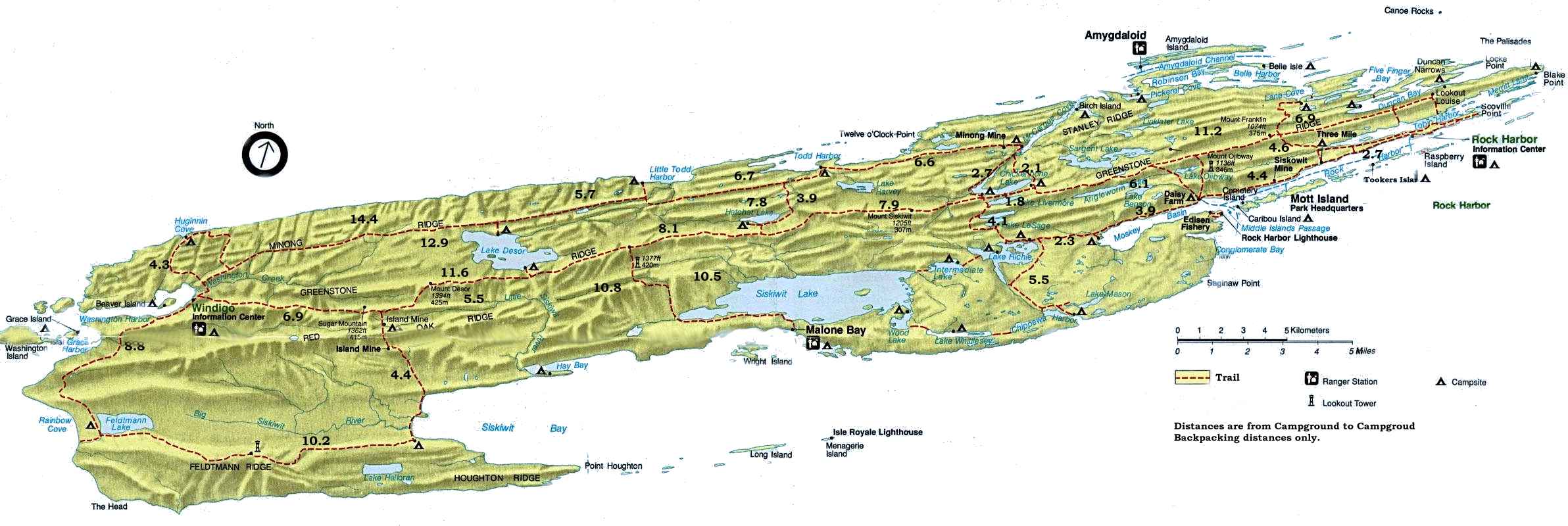
A map of the Island This is the map they hand out at the Ranger Station (188Kb)
What’s
Missing
Todd
Harbor, Malone Bay, and Lane Cove. I’ll
add the information and anything that isn’t subjective as soon as I’m finished
with what I know about the others.
Suggested
Campgrounds
On the western side of the Island I’d
try to hit Feldtmann and Huginnin. On
the eastern end McCargo and Chippewa Harbor are two of the greatest.
Mileage Chart* An amazing milage
chart. And an amazing website.