|
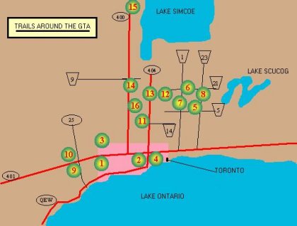
Here's a little map I sketched just to give an approximation of the location of each trail site. At the moment I'm working on getting more detailed maps for each of the site.
|
|
|
Click on Map or Trail List below to see specific trail info
|
|
GTA Bike Trails Listing
|
 Etobicoke Creek
 Don Valley
 Humber - Thackary Park
 Taylor Creek
 Dagmar no longer available
 Durham Forest
 Glen Major Consv.
 Skyloft Ski Resort
|
 Kelso Consv.
 Hilton Falls Consv.
 Jefferson Forest
 York Forest - Porritt Tract
 York Forest - Robinson Tract
 Thorton Bales Consv.
 Hardwood Hills
 Seneca King Campus
|
|
Etobicoke Creek
|
Top 
|
Location: Etobicoke
Length (approx.): 20km
Direction: Located in Centenial Park. From Renforth Drive, go west on Rathburn Road until you past Mill Road and come to a dead end. Trail starts about 30 meter into the woods
Description: This trail stretch from Burhamthorpe Road to Pearson International Airport. Most of the fun parts are on the single-tracks(along the side of the valley) which are divided by the creeks. A double-track trail runs along the bottom of the valley.
|
|
Don Valley
|
Top
|
Location:Toronto
Length (approx.): 7km
Direction: Located on the west side of the Don Valley. There are several entrances to this trail. From Thorncliffe Park OR under Millwood Road Bridge and around the sewage treatment plant OR at the intersection of Bayview Avenue and Pottery Road
Description: Consist of mostly single-track on the side of the valley and can get very technical in some part. Lots of ups and downs and slanted tracks that threatens to throw you into the valley (we ended the season with our buddy injured on this trail) . This trail also connects to other trails that are part of the Don Valley. The trail is also used by many so be alert of others that might be around the bends.
Not Recommended for beginner!
|
|
Humber Valley North - Thackary Park
|
Top
|
Location: North York / Woodbridge
Length (approx.): ??km
Direction: Entrance is at the southwest side of the bridge over the Humber River on Steeles Ave. east of Kipling Ave.
Description: The trails runs north and south of Steeles Ave. The south trails are under-developed and are just short path through the bushes but connects with the pave trail of the Humber Valley which can extend to Lake Ontario. The northern trail (Thackery Park) were created for the Volkswagen/Trek MTB race in 1997 therefore offer decent riding. The Park is an old landfill and you can expect some good hills but nothing too difficult.
|
|
Taylor Creek
|
Top
|
Location: Toronto
Length (approx.): 4km
Direction: Follow Don Mills Rd. until south of Overlea Blvd. and exit on the left side just before the entrance to the DVP. Once on this road, keep right until it ends at a parking lot. The trail begins south of the parking lot.
Description: This trail offers a good ride but is often broken in many places. Some part of the trail might lead to dead ends so ask bikers what's up ahead, unless you like to climb up the side of the valley on foot with your bike upon your shoulder
|
|
Dagmar Ski Resort
|
Top
|
Location: Between Uxbridge(north) and Ajax(south)
Length (approx.): 25km
Direction: From Toronto go east on HW#401 to Harwood Ave then North on Hardwood to HW#2. Head east on HW#2 to Lakeridge Rd.(Rd #23) then North on Lakeridge for about 20km past Durham Rd #5. The entrance should on the (left)west side of the road.
Description: Sorry folks...Dagmar has informed me recently that they no longer offer mountain biking
|
|
Durham Forest
|
Top
|
Location: Between Uxbridge(north) and Ajax(south)
Length (approx.): 25km
Direction: Go East from Toronto on HW #401 to Brock Rd. Proceed north on Brock Rd to Durham road #21 (at Coppin's Corner) then turn east for 5km until Concession road #7. Head south on Conc. Rd #7 for about 1 km and the entrance should on the left side (east) of the road. It is marked with a sign but there might be foliage covering part of the sign...drive slowly.
Description: This is a regular trail site for many local bikers and probably due to the fact that many local MTB races are held here. Durham Forest can boast a wide range of trails for beginner to challenging trails for the advanced bikers. The technical trails are located at the south end of the forest(near the radio tower). Durham Forest is a regeneration project so please stay on the trail.
|
|
Glen Major Conservation Area
|
Top
|
Location: Between Uxbridge(north) and Ajax(south)
Length (approx.): 30km
Direction: Take HW#401 east to Brock Rd. North on Brock Rd about 20km to Durham road #5 at Claremont. Travel east on rd #5 another 6km to Sideline #4(or Concession Rd 7). 3km north on this road should bring you to the site entrance which is marked by 2 boulders on the west side of the road. You will see parked vehicles on the east side of the road, but if you see a white church on the west side then you've gone too far...head back.
Description: There are numerous hills and some very large ones to give you some good climbing. The trail loops are pretty long as well. Personally, this is my favourite trail! This trail is mainly for the advance bikers due to the gruesome hills.
|
|
Skyloft Ski Resort
|
Top
|
Location: Between Uxbridge(north) and Ajax(south)
Length (approx.): ??km
Direction: From Toronto go east on HW#401 to Harwood Ave then North on Hardwood to HW#2. Head east on HW#2 to Lakeridge Rd.(Rd #23) then North on Lakeridge for about 20km past Durham Rd #5 to Chalk Lake Road. Go West on Chalk Lake Road for about 1 km and the entrance is on the north side of the road.
Description: Skyloft opened its MTB centre just recently( 2-3 years ago) so the trails system are not as extensive as other sites. However it is located between Durham Forest, Glen Major, and Dagmar so its landscape is perfect for MTB and they are add more trails. There a entrance fee of $5.
For more info on Skyloft call them at (905) 649-5160
|
|
Kelso Conservation Area
|
Top
|
Location: Milton
Length (approx.): 30km
Direction: Take Hw#401 west from Toronto to HW#25 then north on HW#25 to Rd #9. From Rd 9 go west to Tremaine Rd (rd 22) and turn south until you reach rd 28 and you are at the Kelso conservation area entrance.
Description: Kelso consist of mostly single-track with a few double-track to join them. The trails are on top of the Niagra Escarpment so you will have to climb that 275 ft monster hill to reach the trails. Already sounds fun eh? There are some steep downhills of-course. Trails have lotsa exposed tree roots and rocky(limestone) terrain. The edge of the escarpment have been known to break off. Just be aware of the fact and not take the trail near the edge after heavy rainfalls. The park charges $3.25/person for the scenery.
|
|
Hilton Falls Conservation Area
|
Top
|
Location: Milton
Length (approx.): ??km
Direction: Take Hw#401 west from Toronto to HW#25 then north on HW#25 to Rd #9. Head west along Rd #9 for about 6km and the entrance should be on the north side of the road. If you're unsure of the direction, give them a call (905) 854-0262.
Description: I have not been to this trail site. It's across from Kelso. If anyone has info on this trail then let me know: email me or go to submit a trail.
|
|
Jefferson Forest
|
Top
|
Location: Richmondhill
Length (approx.):6 km
Direction: From Toronto take Bayview Ave north until it end (Bayview continues on the other side of Jefferson Forest) at Stouffville Rd (rd 14). The south entrance is 100 m east of this junction. To get to the north entrance take Younge Street north and past Stouffville Rd. until Sunset Beach Rd. Turn east on Sunset Beach Rd until you reach Bayview Ave. then go south untill it ends at the trail head.
Description: The trails are short because it runs into a few farms. Most of the trails are for beginner and intermediate level. Do not cross into property where you are unwanted. One farmer went so far as to cut down trees preventing bikers from crossing into his property. I've seen bikers cross onto the other side and came back with blown tires. There's a sign somewhere that says 'Keep out - Owner has gun'.
|
|
York Region Forest - Porritt Tract
|
Top
|
Location: Ballantrae
Length (approx.): 2.5km
Direction: Go North on Kenedy Rd until you pass Aurora Rd (rd 5)by 0.5km, the entrance is on the west side.
Description: The trails are mainly fire roads with some single-track that split away and re-join it again. It's easy riding so this is a good spot for beginner to start out.
;
|
|
York Region Forest - Robinson Tract
|
Top
|
Location: Ballantrae
Length (approx.): 2.5km
Direction: Go North on Warden Ave until you pass Aurora Rd (rd 5)by 0.5km, the entrance is on the west side.
Description: Same as the Porritt Tract these trails are like riding through someone's back yard. Not very challenging but give a good feel for beginners.
|
|
Thorton Bales Conservation Area
|
Top
|
Location: New Market
Length (approx.): ??km
Direction: Head north on HW#400 to HW#9 then east on HW#9 to Dufferin St. From there go south on Dufferin to Sideroad 9 then east for about 1km and the entrance is on your left(north side of the road).
Description: ?? Haven't been there...you tell me.
|
|
Hardwood Hills
|
Top
|
Location: Barrie
Length (approx.): 75km
Direction: Take HW#400 north to exit 111 at Dalston(rd 11) and continue east on Dalston pass Edgar for 5 km and the entrance should be on the left(north side of the road). This site is just south of Horseshoe Valley.
Description: Obviously it is a little further than the GTA region but what the heck...this is the Best site in Southern Ontario. It comprises of 75km of trails! Most major MTB races are held here for a reason (including the infamous '24hrs of Adrenaline'). There a wide range of trails and as a bonus, great facilities such as showers, bike shops, cafeteria, and bike wash station. This come with a price of-course, the fee is $7/person.
This site is a must!
|
|
Seneca King Campus
|
Top
|
Location: King
Length (approx.): 15km
Direction: Located north of Seneca College. Go north on HW#404 to Bloomington and then west to Seneca College. OR go north on HW#400 to exit 43(king Rd) then east to Dufferin St. Proceed north on Dufferin to Seneca College.
Description: These trails are maily ski trails north of the campus and can join up with other trails along the Oak Ridges Moraine. The trail west of the campus is closed to bikers and to the east is mainly single-track, continuing along this will lead to Henderson Dr. This road will eventually lead to Henderson Forest where there are a few more single-track but maily it is double-track.
Try to link this trail up with Jefferson Forest to the South-East
|
| |
|
|
|