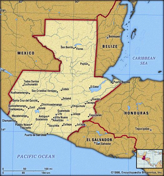
| General Information.
officially REPUBLIC OF GUATEMALA,
Spanish REPÚBLICA DE GUATEMALA, third largest country of Central
America, covering 42,042 square miles (108,889 square km) in the northwestern
corner of the isthmus. It is bordered on the north and west by Mexico;
on the northeast by Belize and the Caribbean Sea (at the Gulf of Honduras);
on the east by Honduras and El Salvador; and on the south, along its 150-mile
(240-kilometre) coastline, by the Pacific Ocean. The population in 1990
was estimated to be 9,197,000.
Demography
Guatemala's most extensive lowland
is the Petén portion of the Yucatán Peninsula and the Caribbean
(Atlantic) littoral in the north. Highlands comprise about half of the
total area and cut across the country's midsection generally southeast
to northwest. A narrow Pacific coastal plain stretches the length of the
country in the south.
Guatemala is located in the tropic zone, but temperate seas and an irregular terrain provide a diversity of climates. At sea level average annual temperatures range between 77 and 86 F (25 and 30 C). At elevations greater than 6,000 feet (1,800 m), temperatures may be as low as 50 F (10 C). There is a marked dry season from November to April. On the Caribbean coast, where the winds that rise from warm offshore waters blow throughout the year, there is hardly any dry season. In the central region the annual rainfall varies from 80 inches (2,000 mm) in the high plateaus to less than 40 inches (1,000 mm) in the arid section of the eastern part and along the middle section of the Motagua River valley. The northern tropical forests of
the Petén are rich in fine woods, rubber, and a variety of palms.
Vegetation is similar in the Caribbean littoral region, and mangroves are
found on the coast. Except for the highest slopes in the volcanic highlands,
stands of pine, fir, willow, and oak have been largely destroyed. Wild
animals such as the deer and monkey are increasingly rare. Guatemala has
deposits of nickel ore, copper, lead, zinc, iron ore, and antimony; petroleum
reserves are located in the northwest of the country near its border with
Mexico.
The population is divided into two
principal groups: American Indians and Ladinos. The Mayan Indians compose
about 55 percent of the population and live primarily in the western highlands.
Ladinos, comprising about 42 percent of the total, are mostly of mixed
Hispanic-Indian origin. There are a few whites and blacks. Slavery was
abolished in 1824, and the freed black slaves soon mixed with the Indian
and Spanish population; called Black Caribs, they mostly live in the Caribbean
lowlands. Guatemala's official language is Spanish, but approximately 20
Indian languages are also spoken. There is no established church, but the
prevailing form of religion is Roman Catholicism. There are a few Protestants
and Jews.
Guatemala belongs culturally to
the Hispanic-American world, but the presence of the Indian has given the
country's culture a distinct accent of its own. Two of the country's greatest
writers, Mario Monteforte Toledo and Nobel Prize winner Miguel Ángel
Asturias, addressed the place of the Indian in national life. Many of Guatemala's
painters and sculptors have been influenced by the Mexican muralist school.
Indian art--in particular, handwoven textiles, pottery, clay, and wood
carvings--is of high quality. Traditional dances, music, religious rites,
and games have survived in the Indian regions.
Copyright 1994-1998 Encyclopaedia
Britannica
|