

LORRAINE PRIMARY SCHOOL / LAERSKOOL LORRAINE, Lorraine, Port Elizabeth (until 1967, Walmer).
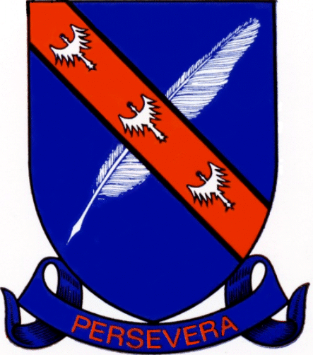
The arms, devised by Cor Pama,[1] may be blazoned:
Arms: Azure, a quill pen in bend sinister proper, over all a bend tenné fimbriated or, charged with three alerions argent.
Motto: Persevera.
About the arms:
The arms were adopted by the school committee and staff in 1973, and Pama sent his final drawing to the school in March 1974. For some reason they were not registered at the time with the Bureau of Heraldry, and arrangements are currently being made to register them.
There is an apparent contravention of the tincture rule in the arms as illustrated, in that the bend and the field are both of tinctures (orange on blue). But for three reasons this is an invalid criticism. Firstly, if the field is regarded as being a composite of blue and the “proper” (or white) of the quill, the colour of the bend is irrelevant in terms of the tincture rule. Secondly, the bend’s colour is one of the three heraldic colours classified as stains, which are in a separate category from tinctures. And thirdly, as the blazon makes it clear, there is supposed to be a gold (or yellow) fimbriation, or fine line of separating colour, on either side of the bend, which is not apparent from the illustration.
Orange, white and blue are the colours of the South African flag in use from 1928 to 1994, so the choice of colours could well have been patriotic. The same colours (although in an entirely different combination) also appear in the arms of the neighbouring Sunridge Primary School.
The quill pen (usually the wing primary of a goose) was for centuries the normal instrument for writing in Western Europe and elsewhere, and appears here as a symbol of learning.
The alerion[2]
is a strange device, having the form of a small eagle but lacking both beak and
legs.
Fox-Davies[3] comments on this charge:
“A curious form of the eagle is found in the alerion, which is represented without beak or legs. It is difficult to conjecture what may have been the origin of the bird in this debased form, unless its first beginnings may be taken as a result of the unthinking perpetuation of some crudely drawn example. Its best-known appearance is, of course, in the arms of Loraine; and, as Planché has pointed out, this is as perfect an example of a canting anagram as can be met with in armory.”
Fox-Davies does not account for the odd spelling of Loraine with one R, without which the anagram would be pointless. Canting or punning devices were highly popular with mediæval lords and their heralds, although anagrammatical ones are less frequently encountered.
The motto was retained from the old school badge. It translates as “persevere”, or more literally “go through hardship”.
Pama recommended dropping the earlier badge in which there was a large amount of lettering in the shield area, and the central emblem was a rather small lighthouse. Since lighthouses are commonly seen in the badges of many schools along the coast, he felt that could easily be dropped.
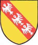
In their current form the arms are
a clear reference to the mediæval and early modern Duchy of Lorraine,[4] which was ruled by a duke theoretically owing his allegiance to the Holy Roman Emperor, but to a large extent a free agent in his dealings with his neighbours, including the King of France.
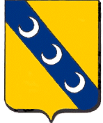
It would seem, however, that Pama might even have derived the colours from an inversion of those in the arms of the city of Lunéville[5] in Lorraine, which are: or, upon a bend azure three crescents argent.
Pama’s Afrikaans blazon specifies that the alerions (in Afrikaans, “geknotte adelaartjies” are aligned to the (diagonal) bend. While this is necessary in Continental heraldry, it is assumed in British heraldry that charges will follow the alignment of a diagonal charge; it would only be necessary to specify if they were, for example, upright.
Duchy of Lorraine:
The simple arms of the dukes of Lorraine were: or, upon a bend gules three alerions argent.[6] (These were borne as part of a far more complex achievement by the later dukes.)
The last member of the House of
Lorraine to reign over the duchy was François-Étienne I (*1708 †1765), who in
1736 succeeded in marrying Maria Theresia of the House of Habsburg, who from
1740 was Queen of Bohemia and Hungary and Archduchess of Austria. However, a
condition of his marriage laid on him by Maria Theresia’s father, the Emperor
Carl VI, was that he cede Lorraine to Stanislaw[7] Leszczynski (previously King Stanislaw I of Poland), a sacrifice required by France in order to end the War of the Polish Succession (ended in 1738).[8]

Duke Stanislaw, father-in-law to
King Louis XV of France, held Lorraine until his death in 1766. The duchy was then incorporated into France as an administrative generalité under an intendant based in the capital, Nancy.
François-Étienne was compensated
with the title Grand Duke of Tuscany, and was eventually elected Emperor, as
Franz I, in 1745. His and Maria Theresia’s descendants (the last Holy Roman
Emperors [until 1806] and the Emperors of Austria [1804-1918]) were known as the House of Habsburg-Lorraine.
The duchy was not a cohesive geographical unit, due to the separation from it of the so-called Trois-Évêchés (Three Bishoprics), three cities which during the High Middle Ages became prince-bishoprics and so were separated from the duchy, leaving the duke’s territory looking like a jigsaw puzzle missing about a fifth of its pieces.
These were Metz (which had been King Lothair’s capital, and which became an imperial free city in the Middle Ages, became Protestant in the 16th century, and was the scene of a major battle in 1944), Toul (which in 1545 placed itself under the French King’s protection) and Verdun (where Charlemagne’s grandsons had agreed to divide the kingdom, and the scene of prolonged battles in 1792, 1870 and the First World War). In 1648 the three cities became part of France under the Peace of Westphalia.
Lorraine lies along the rather
indistinct historical boundary between the Romance- and Germanic-speaking
regions of Western Europe, and a small part of it (slightly less than
one-third, being the home of a slight German-speaking majority, and chiefly territory that had not been part of the Duchy of Lorraine) was annexed by
the German Empire following the Franco-German War of 1870-71, forming with
Upper and Lower Alsace[9] the Reichsland Elsaß-Lothringen.
During the First World War several
major battles were fought in Lorraine. Following this war the Reichsland was
reabsorbed into France.
Lorraine in Walmer:
During the 1930s, the name Lorraine was given by the town of Walmer to an area west of it and Port Elizabeth, being part of the farm Nooitgedacht and newly incorporated into the town. The area was laid out with street names recalling battles fought during the First World War in and near Lorraine, as well as places elsewhere.
The township or suburb lies south of the Baakens or Kabega River (which was the northern boundary of the Walmer municipality), and borders on the narrow-gauge railway line[10] linking Port Elizabeth with the Langkloof. South of the line lies Lorraine Manor, which also has French street names.
One street was named Saar, for the
German territory occupied by France after both world wars, another for Lourdes,
the pilgrimage centre in the far south of France.
People living in and near Lorraine
and Lorraine Manor are often unaware of the French origins of the street names.
While not all the area’s streets have the names of places in or near France, many do, thanks to a directive from the town council requesting names that had some connection with France or with the World Wars. Some of the names belong to rivers, for which district administrations, or départements, have been named. On this list, the links are mostly to web pages that have arms, flags or both of the places or regions:
Aisne Avenue, Alsace Road (arms, flag), Ardennes Road, Arras Road, Arricourt[11] Avenue, Ascain Road, Aube Street, Bayeux Road, Belvédère Road, Besançon Road (arms, flag), Blanc[12] Road, Bordeaux Road, Caen Road, Calais Road (arms, flag), Carentan Road, Cézanne[13] Road, Châlons[14] Road, Chartres Place, Chaumont Road, Cherbourg Street (arms, flag), Clermont[15] Street, Cluny Avenue, Coligny Road, Colmar Road, Courcelles[16] Road, Crozant Street, Debre[17] Street, De Gaulle Crescent, Delville[18] Road, Dijon Road, Épinal Avenue, Flanders[19] Road, Grimaude[20] Street, Jardin[21] Street, Lacroix[22] Road, Le Havre Street, Le Mans Road, Lemorne[23] Street, Lille[24] Road (arms, flag), Longwy Avenue (arms, flag), Lorient Place, Lorraine Street, Lourdes Avenue, Lunéville Road, Lyon Crescent (arms, flag), Mâcon Road, Marne Avenue, Marseilles Avenue (arms, flag), Meuse Avenue, Menton Road, Metz Avenue, Mimes Road, Mirecourt Avenue, Montagne Street, Montmédy Avenue, Moselle Road (arms, flag), Murville Street, Nancy Road, Noire[25] Road, Orléans Street, Orne Road, Pompadour Avenue, Rennes Road, Rhône Place, Rouen Road, Ryn[26] Street, Saar Street, St Lo Street, Sarthe Street, Sedan Avenue, Seine[27] Street, Somme Avenue, Tarbes Street, Tarn Avenue, Thionville Road, Toulon Road (arms, flag), Toulouse Street (arms, flag), Tours Road, Verdun Road, Versailles Road (arms, flag), Vitry[28] Avenue and Vosges Road.
About the school:
The school as it is today is a coeducational parallel-medium primary school (Grades 1 to 7, previously Sub A, Sub B and Stds 1 to 5), occupying premises in Jardin Road facing a square park (diagonal to the street grid) at the intersection of Jardin Road and Meuse Avenue, while the school fields abut onto Dijon Road (which runs along the railway line) and Marne Avenue.
It had its beginnings in the early
1940s, in a petition to the Port Elizabeth School Board[29] signed by about 40
parents living in Lorraine requesting the establishment of a school in their
own area, which was then a largely rural suburb.[30] They were unhappy over the distances their children had to travel to schools in
Newton Park,[31] Fairvew and Walmer.[32]
A two-roomed school catering for English- and Afrikaans-speaking pupils was opened in Vitry Avenue on 11 April
1944. The principal was Mr J G Kilian, previously on the staff of the Laerskool
Excelsior, in Port Elizabeth’s Mount Road area, and his sole staff member was a
Miss Romm.
The opening ceremony was attended
by several parents from both language groups who promised their support and
co-operation – something which has become a marked characteristic of the
school.
By August 1946 there were 54
pupils, of whom 18 were English-speaking. This qualified the school for a third
teacher, a post approved from January 1947 – despite the fact that already in
1946 the teachers had to stand in the doorways of the overcrowded classrooms.
Additional accommodation was provided in the form of prefabricated army huts.
By 1952 pupil numbers had grown to
127, and five more teachers had been appointed. Even with the army huts, it was
necessary to use rooms in private homes as classrooms. Teaching, however, was
satisfactory in the view of inspection reports.
In June 1948 Mr Kilian visited the
Cape Province’s Superintendent-General of Education, Mr W de Vos Malan, in Cape
Town, and the new building was placed at the top of the department’s building programme priority list.
In April 1951 the tender of the
firm Dunn & Lees was accepted for a contract amount of £18 928 7s 7d, and
on 1 May 1952 the new building was ready.
But already accommodation was
insufficient and the staffroom had to be used as a classroom, even though the
staff now stood at seven full-time teachers and a part-time speech therapist.
In 1956 the same building was being used by 10 teachers and 238 pupils. Additional accommodation was completed in 1958.
Lorraine Primary’s first school
committee was appointed in October 1967, under the chairmanship of Mr T F
Roberts. A school committee election held in 1970 was aborted because of the
lack of a quorum, and the Port Elizabeth School Board was obliged to appoint
the new committee. This committee was still in office when founding principal
Mr Kilian retired in March 1973.
Lorraine’s rural character meant
that the installation of a telephone in May 1952, and of electricity in the
school building in the fourth term of that year, were red-letter events.
The school also took up use of an
art room in November of that year, and the first school function in the new
building was held on 12 November.
Municipal water was laid on only in 1961, but sewerage took more than a decade longer. A temporary drainage system was installed in 1974.
Mr Kilian’s successor visited Cape
Town shortly after his appointment and saw the MEC for Education, Mr G Lubbe.
This visit resulted in the calling of tenders for further extensions, including
a school hall, named after Mr Kilian.
Work started in June 1977, and the
opening in November 1979 was performed by Mr Lubbe’s successor, Mr F A Loots.
A history of the school published in the programme for the inauguration of the school hall and extensions in 1979 states that over the previous 35 years the school had never lost a teaching post because of a drop in pupil numbers. Numbers have, in fact, risen by a near-constant 10%. The complement at that stage was 483 pupils, 22 staff and a clerical assistant.
